

n1vek
-
Posts
232 -
Joined
-
Last visited
Content Type
Profiles
Blogs
Forums
American Weather
Media Demo
Store
Gallery
Posts posted by n1vek
-
-
It is shocking how consistent the models are with this storm setup. It makes total sense as I am supposed to fly from DIA to Love Field in Dallas Wednesday early afternoon.
-
3 hours ago, smokeybandit said:
Some wicked fog on the Palmer Divide this morning. Visibility like 200-300 feet, at least from my back deck.
Same up here in Arvada. Pea soup.
-
This is absolute trash.
-
This has been a pretty decent pattern for the front range foothills and mountains. I know we have a long way until the end of "fire season" (in parenthesis because does it really ever end??) - but this has been a low drama summer so far with decent enough precip, periods of very high precipitable water anomalies, and "humidity".
Cheers to landing in mid-October with little drama and a snowstorm in the forecast.

-
1 hour ago, mayjawintastawm said:
Interesting- the thunderstorms last night that dropped about a quarter inch of rain on us served to suppress basically all the rain for the Urban Corridor today. Was supposed to be quite juicy, but no sun=no lift.
I was thinking the same thing. Ended up with just a humid and cloudy day. I guess given the top layer of soil being so saturated, knock on wood, we may have avoided any big flooding issues.
But let's run this rain back again in a week please.-
 1
1
-
-
It really seems like the mountains have been doing quite well with these waves. Great to see and hopefully it keeps the fires at bay. Down here in the urban corridor, it has been a bit more hit and miss. Certainly below average for the season so far. It seems like most days there are chances that fizzle as they drop off the higher terrain (as is typical I suppose?)
-
Fun stuff. Happy to be a part of it.
-
1 hour ago, smokeybandit said:
Doesn't seem to be looking good for much moisture getting into NE CO
Kind of typical for the monsoon. It'll always bias south and west, especially early season? Fingers crossed it creeps up this was as models had been communicating for awhile.
-
Lovely soaking tonight in Arvada. That band out north of the city has been stationary and dumping for awhile now.
-
It's been a nice run for moisture. Hopefully the Tuesday night "event" delivers and we keep this good luck steak running into June.
-
Anyone have a good total precip map for this entire event? Curious how different parts of the metro did.
-
Max depth on my deck was 4” but it was melting the whole way at 5500’ in Arvada. Snapped the crown off a maple in the backyard and have several other large limbs on the ground/roof.
-
Transitioned to snow here in Arvada a bit ago. Light slushy accumulation on the grass and deck so far.
-
55 minutes ago, mayjawintastawm said:
Elevation list of frequent posters in this subforum (feel free to insert yours) from highest to lowest: guessing on order for many based on city. I don't think we have any in the "real" mountains over 9000 feet.
ValpoVike: 7310'
Smokeybandit: 6300'
Mayjawintastawm: 5650'
N1vek: 5500'
Co Scifan:
Chinook:
Raindancewx (Albuquerque):
-
Winter Storm Watch for the urban corridor/foothills signaling 4-10". I'd imagine it will be very elevation dependant.
I want all of the moisture and none of the limb-breaking snow please.
-
1
-
-
19 minutes ago, mayjawintastawm said:
I dunno but the Fri-Sat forecast is getting even juicier. I think this time of year, handling convection throws the models off a lot.
Agreed. Until I see the pros put it in a point and click forecast, it's probably out to lunch.
Either way, the NWS is interpreting the models to still drop a really nice storm on the front range.
-
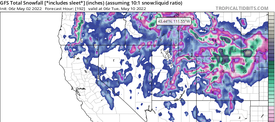
Wtf is the GFS doing right now...
-
Really hoping the models hold together/trend even wetter. I know beggars cant be choosers, but whenever we have a chance at meaningful precipitation in this awful pattern, I get greedy.
-
On 4/24/2022 at 7:43 PM, n1vek said:
Nice to see an overperforming event at least somewhere. A Basin looks to be doing pretty well. Ground is legitimately wet here in Arvada, hopefully we get some luck and this carries on for the evening. Long-range models make it look like this is the last chance for precip until the 2nd week of May.
Aged quite poorly. At least there has now been one example of "models giveth" vs the constant trend of taketh as we creep closer to a forecasted event. The rains the last few days have been quite nice.
-
2 hours ago, smokeybandit said:
God love ya GFS
Euro was showing some pretty cracked outcomes for this rain event we just had a few days ago.
Just need one of these big storms to materialize for the benefit of my lawn.
-
Watching the models constantly pull the rug on precipitation has been frustrating.
-
3 hours ago, ValpoVike said:
A surprisingly good snow event ongoing up here. I didn't expect any accumulations at all today, but close to 3" over the past 1.5 hours. This is really good to see up here in the Larimer County foothills.
Edit- at 6” now this is so good to see
Nice to see an overperforming event at least somewhere. A Basin looks to be doing pretty well. Ground is legitimately wet here in Arvada, hopefully we get some luck and this carries on for the evening. Long-range models make it look like this is the last chance for precip until the 2nd week of May.
-
Euro pulled back on the precip for the front range again with next weeks storm. Makes total sense, go with the trend, etc - getting very worried about fire season and I just don't believe a productive monsoon exists anymore.
-
It is really frustrating. I know it is drier here than where I moved from (Michigan), but it seems like a total thread the needle event to get a good qpf event here.
Mountain West Discussion- cool season '23-24
in Central/Western States
Posted
I am ready for proper fall weather - I have been trying to enjoy the mountain biking season as long as it lasts, but honestly the trails are getting pretty moisture starved. They need the slow/wet season to kick in soon.