
zenmsav6810
-
Posts
972 -
Joined
-
Last visited
Content Type
Profiles
Blogs
Forums
American Weather
Media Demo
Store
Gallery
Posts posted by zenmsav6810
-
-
I had to go into work really early. According to the car thermometer at 4:30am it was 41F in North Coventry I got to Coventryville it was 26F, East Earl it was 36F at 5:25am. Strange fluctuations.
-
Just now, Ralph Wiggum said:
Most of us here weren't surprised....except.for the couple sticklers that wanted to force winter to end.
Not sure how you can rage quit winter... its not even March yet!
-
 5
5
-
-
This one is probably the most difficult forecast of the year. Modeling has this storm to spread out. If anyone is to cash in the gradiet will need to be tighter. Leave it to Fox 29 to pull the rabbit out of the hat to make up for the misses this season.
-
7 minutes ago, mattinpa said:
No I thought Wentz was done here. Part of that could have been the moves Roseman made, but Wentz wasn’t blameless. I don’t think we should give up on Hart yet.
Carson had 4 years to make his case. He's bad news Bears.
-
1
-
-
50 minutes ago, ChasingFlakes said:
I'm 25, born in March 95. I played for the Valley Forge Minutemen, and West Chester Quakers growing up. My dad was my assistant coach my whole life but unfortunately he passed away from a heart attack on the ice at Oaks in 2012. He was only 46, bad genes suck!
My cousins son is a minuteman!
I've always have been a golf fan, Justin Rose and Sean O'hair are some of the hometown favorites around here. Do we have any other golfers on here?
I've always like Philly sports, I'm probably most partial to the Eagles, The Phillies are my NL team and I dont follow the NBA or Hockey very much.
-
Good .2" of icey/sleety crust here in North Coventry this morning... late to work.
-
1 minute ago, Wentzadelphia said:
RIP username
Could switch it to Wentzisaweenie
-
 2
2
-
-
On 2/15/2021 at 4:32 PM, Ralph Wiggum said:
The fact the euro is the southern outlier and given its less than stellar track record AND with the NAM being consistent with the sleet/ice look, we shouldn't write the NAM off nor the warmer solutions. It certainly has some merit in that solution.
Can I have that in writing?... oh wait.
-
1
-
-
8 minutes ago, Albedoman said:
my feelings as well. I am having real good laughs on how panicking is setting in for some of the youngsters. This is a run of the mill overrunning snowstorm event and who ever gets dry slotted also gets the majority of the snizzle. Likely to see heavy banding set up before noon on Thursday with intermittent periods of snizzle adjacent to where downsloping is occurring near the heavier bands.
In my limited experience as a youngster I whole heartedly concur. The NAM tends to score well with these over running events!
-
2
-
-
27 minutes ago, Ralph Wiggum said:
You cant just cherry pick the snowmaps with the hottest pinks to fit an agenda. Like Wentz said, we have time...30 hours....but this didn't just tick the wrong way, we saw some large jumps at 0z so far headed the wrong direction. Less juice, less waa, coastal destroys thermals.
8 minutes ago, Snowcane21 said:We must be looking at something different. All the 0z runs so far have been colder. All still depict a general 4-8” snowfall over most of the region. In fact the 0z Nam was its coldest run yet...
Just now, RedSky said:My 0z take is Ralph is go MECS or go home hehe
Weenie jump in our hour of triumph? Dare, say are the words of a man sick of snow!
-
 1
1
-
-
2 hours ago, KamuSnow said:
Is this the map? Looks like more of a Virginia feature, which they don't really need since they are still recovering from ice this past weekend:
Sorry Folks, I was away at a meeting. Thats the one I am refering too Kamu. I should have copied it in.
-
DT has a map out.... first one of his this season that I think will verify. He Thinks the ice storm risk is significant. Makes sense the last interior ice storm hit almost this time of year was that 13-14?
-
DT just asked for a divorce from the Euro and UKMET...
-
"December to remember" or "February to remember where 'ye!...."
-
51 minutes ago, Ralph Wiggum said:
It is a flat ridge, but its there. It was supposed to be raging with the Nina. But we luckily have had the -NAM state working for us to counter it. If the ridge was non-existent we would be congratulating NC/SC. But as we've seen countless times recently, there is a battle going on between the -NAO and that SER reflection. And subsequently every system has come N. I personally don't buy the squashed look on the Euro. Not suggesting every wave comes N and flush hits us....but I am anxious to see the battle that ensues in the atmosphere over the next 10 days between those features I mentioned.
This -NAO and that SER reflection is a bit like standing on one foot. Not super stable but it can still stay like that for awhile np at least until something pushes it over. The forecast looks snowy. I wonder why the Euro is having problems with this.
-
Big old fat Ole flakes here in chester County pottstown. Perhaps the biggest of the season. Rebecca's northeast weather has the upside covered for this storm
-
Everything covered im glad church was canceled!
-
13 minutes ago, Kevin Reilly said:
Last minute cover in case snow rates are light and snow melts where it counts on paved surfaces
and here i'm calling Cecily the lawyer... unbelievable thats an amateur forecasting tactic if I ever heard one.
-
17 minutes ago, chrisl said:
Somehow the SREF has a better chance of 12+ across south Jersey than 8+. I mean I'll take it I guess
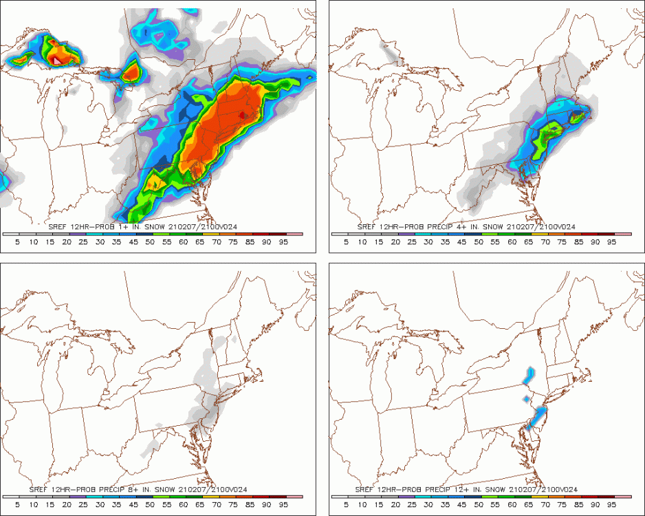
That seems to be almost a fallacy or bug.... wouldn't the probability of 8"+ be included in the mathematical intersection of 12"+ ....if it was the probability of 8-12" then it would make sense as the probability of 8-12" would be part of the complement of the probability of 12"+


Of course weenie rule #119 is never look modeled snow in the mouth!
-
1
-
-
40 minutes ago, MGorse said:
That was basically to match up with Lancaster County in NWS State Colleges area.
That makes me feel better actually! Thanks!
-
1
-
-
2 minutes ago, Moderately Unstable said:
I mean, as I said last night in reply to Ralph's post asking if anyone thought there was room to bust...I'll repeat, there is. That said, for a modest event like this, really the absolute lowest snow amount that qualifies for a WSW (5"): https://www.weather.gov/phi/WinterWx
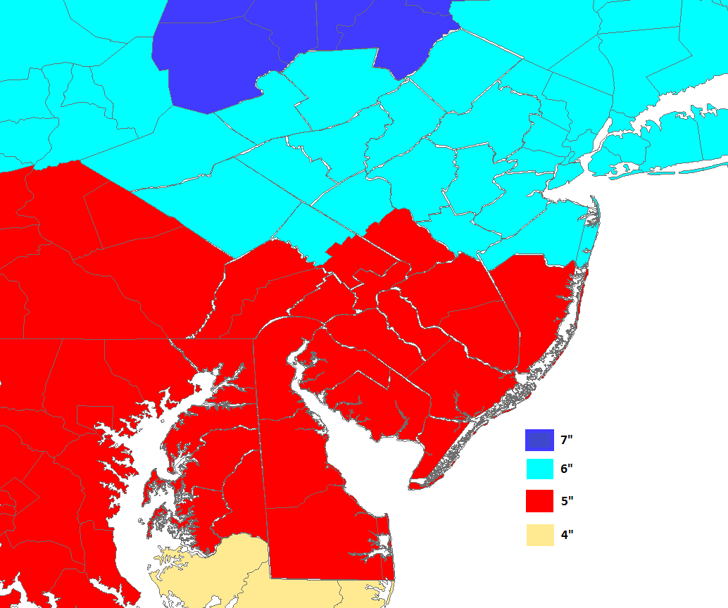
(Note-- above map is for a *12* hour event)...your low end estimate is going to be low somewhat often. It's unlikely the region on the whole sees <1". It is quite possible we end up with more spots getting advisory level snow totals though than warning. This will be a dynamics battle: cooling from the strong fgen, versus marginal bl temps and an eh airmass. Round 1, ding ding.
It triggers me that nw chester isn't in light blue. It's like they should continue the border from berks count to the east west median in Chester. We are used to getting snow in French creek, elverson, pheonixville, Bucktown, malvern, pottstown, Coventryville, Nantahala, chestersprings....we can handle it.
-
Just now, Birds~69 said:
That's the gambling odds ( KC -3.5) for the Superbowl, already took KC to cover for $100. So 4"+ in my neck of the woods is a lock...
Money comes to snow or a fool and his flakes soon parted?
-
1 minute ago, Prairie Dog said:
Sorry, I have little respect for her forecasting skills. We all know the reason she is there, and also Brittney Shipp is the chief met at NBC10. I will take Glen, DT, and the NWS over those two any day of the week, seven days a week. For the folks that have WFMZ, Allentown, their mets are pretty good as well
This thread isn't to debate vendor mets but I find that the WFMZ forecasters are pretty good, I think they get the broadcast/scientist mix correct. Personally I think Cecily has a broad appeal, however I notice she has a tendency to "lawyer" her forecasts to protect against the downside.
10 minutes ago, Kevin Reilly said:Canadian agrees
From what I've come to understand is that the Candian is a bit of an after thought for many forecasters. I notice it does best in our area with ice events where there is a lot of bombogensis going on.
-
38 minutes ago, Animal said:
Not sure yesterday... weak people were upset with me regarding my bust thread.
Easy does it-- lets just keep the forum rules in mind. This is intended to be a somewhat professional foum. Professional forecasters (and high level ametuers) tend to get upset with people that get overly emotional with forecast/outcome. If we want those valued contributers to continue to grace our presence here we should keep their user experience in mind. We have the added responsibility here that we are self moderated in this forum.
21 minutes ago, RedSky said:If there is an elephant in the room here the air mass in place is tepid cold so it's a close call
For that reason I think the quicker the storm the better. I'm hoping for a regular old blitz blizzard. So quick it never has a chance to warm up.... Earlier probably helps us out too with the precip type. I think these kinds of setups work out well for us NW of 95. They are almost like mini-miller A's. The frontgensis aspect of this storm might be getting over amped by the NAM especially the hi-res. I have a feeling the Euro has a good final answer to this storm despite being 1000 miles off course 36ish hours ago! Never under estimate having snow on the ground for helping with temperatures. Snow comes to snow like money comes to money!
-
1
-
 1
1
-
E PA/NJ/DE Spring 2021 OBS Thread
in Philadelphia Region
Posted
Daffodils are starting to poke up through the ground/snow, pansies are out for sale at the green houses in Amish country! Rare Snow Rollers reported by WFMZ: https://www.wfmz.com/news/feature-belt/snow-rolls-spotted-in-the-lehigh-valley-berks-county/article_ef6cb8d8-7988-11eb-bf00-2b72931471e5.html
For those unfamiliar: https://en.wikipedia.org/wiki/Snow_roller