

zenmsav6810
-
Posts
1,003 -
Joined
-
Last visited
Content Type
Profiles
Blogs
Forums
American Weather
Media Demo
Store
Gallery
Posts posted by zenmsav6810
-
-
24 minutes ago, Kevin Reilly said:
Same dam stuff maybe we are setting up by mid March to early April at this point.
Thats okay- by that point we'll need the rain.
-
 1
1
-
-
Nobody start the threads until its over the Carolinas.
-
15 minutes ago, JTA66 said:
Same. After the first week of March, I just don't care anymore. If something pops up, I'll track it. But failure doesn't bother me, say after 3/5, the way it does in Dec, Jan or Feb. But that's me. Every weenie is different.
Beings I'm a ski instructor my tracking habits shift northward. Vermont can be very nice in Late March plus the extra daylight!
-
10 minutes ago, Kevin Reilly said:
Interesting that the Mertztown and Huff's Church totals are so low when New Hanover, Alburtis and Fleetwood totals are high. Also Emmaus- two different measurements.
-
1 hour ago, jwilson said:
I measured about 3.1" - which is technically a bust on the revised forecast, but the first NWS forecast was a winner. Those last minute short-range revisions were fool's gold, in hindsight.
That all fell in about 3-4 hours, too. From onset of snow around 11 AM to say 4 PM, we only had maybe 0.5" of accumulation here.
Better safe than sorry? Higher totals seemed to hold serve in the NW interior. Perhaps it seemed to necessary to hedge bets with Philly due to risk?
2 minutes ago, MGorse said:I am glad this storm is over.
These frontal systems must be the ones that make you guys nuts!
-
The Canadian always seems to do okay when there's been a lot of cold air around. Nam has been scoring well and tends to model frontogenesis well. How does cold air damming work into the mix?
-
14 hours ago, Albedoman said:
funny you said this. I lived less than .5 mile from the ongoing Hurst fire location back in the 1970's. My parents old house was in the voluntary evac last week in Newhall/Santa Clarita Valley. Many times when I was in high school, I had to water down the roof while helicopters were dumping water on our property and with red fire retardant. Had a huge firewall/break in my backyard. Believe me a can write a book about my life's weather experiences from the climate/weather patterns from Ca to the mid west to the east coast. From tornadoes and 1.5 inch ice storms in Memphis Tn, blizzards and extreme cold in Wisconsin -25 degrees , to dust/fire storms in California and Mojave Death Valley temps in the 120's, to hurricanes in Mississippi, earthquakes and finally all the weather here in eastern PA since the 80's
I would get up in the morning in Newhall, shivering from low 40's and in the same afternoon I would then be swimming in my neighbor's pool at 85 to 95 degrees with 50 mph Santa Ana winds blowing and humidities down to 9%. I have experienced rain at the Newhall house and then driving up that afternoon to Gorman/Tejon Pass (less than 25 miles) and getting my car stuck in 4-6 ft snows (not drifts) with snow blowers(not Plows) clearing I-5. I actually have B/W photos of this experience I could post.
red fire retardant... that explains everything!
-
flurries! (here at work in Caln Twp.)
-
 1
1
-
-
30 minutes ago, dizzy9479 said:
In New Jersey, students are not permitted to have virtual snow days in public schools. During the pandemic, a law was passed that the only circumstances under which a school can go virtual is for health reasons.
Well isn't that just great for New Jersey! ....Didn't know that, thanks for the info.
-
4 minutes ago, kickingupastorm said:
Can’t believe schools closed for this nonsense. Kids these days have it easy. I’m 37.
Except there's no such thing as a snow day- rather the kids have to telecommute for their flexible instruction day like mini-adults on their laptops! Communicable illness and the fact their is more fast moving traffic on the roads today also weighs more heavily on the decision making these days.
-
Fat flakes in Caln Twp. here at work. Peaceful snow but the roads were pretty bad even with just 1/4" this morning.
-
Wiggum Rule holding serve
-
 1
1
-
-
9 hours ago, zenmsav6810 said:
Some very loud and powerful thunder just rolled through here about 10 minutes ago. It's been a long time since I've been frightened by thunder like that probably some of the loudest I've ever heard.
I guess this was probably caused by the inversion layer last night. Some reading that I did said thunder can reflect off the warm layer.
-
Some very loud and powerful thunder just rolled through here about 10 minutes ago. It's been a long time since I've been frightened by thunder like that probably some of the loudest I've ever heard.
-
1
-
-
On 11/19/2024 at 6:08 PM, Ralph Wiggum said:
Remember when Eagles fans wanted to tank the season and fire Siriani after week 4?
Weenies being weenies.
-
23 minutes ago, JTA66 said:
The NFL should ban dome stadiums.
No No No please don't do this! My company sold the material that made SoFi stadiums roof!
-
2 hours ago, RedSky said:
I thought Philadelphians tap water was Schuylkill punch?
Must be an old wives tale..
This body of water empties into the Perkiomen which in turn empties into the Schuylkill.
-
Trace of Fog today... Skies were slightly gray yesterday afternoon.
-
 2
2
-
-
16 hours ago, Albedoman said:
I have been calling for this severe drought since June. No longer a laughing matter right guys? Once the limestone streams go dry, all hell will break loose with PADEP. I awaiting PA Fish Commission to be discussing the fish loss in uppper reaches of the main trout streams real soon in the media. Just about every municipality in the LV has declared a burn ban and the LV is even in listed in the fire watch areas for the entire nation. I promise you that tons of landscapers and residents will be watering later this week when the temps are in the 80's agin, sucking down those groundwater levels big time and drying up base flows in the smaller streams. Tons of landscaping trees, bushes and new lawns are being established right now only by irrigation. Golf courses are being watered big time too since the sunny warm weather is giving them tons of customers. Car wash businesses are booming after a brief sprinkle in the past week as the cars are so dirty from the pollen and dust that has turned to concrete on the cars surface from the sprinkles.
I still believe the extreme drought pattern will break by mid November and we should get some moderate rainfall events. I do expect a nice winter storm around Thanksgiving of a few inches of snow as this is typical of this weather pattern.
By the way, the first rainfall event of over .25 in with even a moderate breeze will bring down the leaves all at one time. The leaf piles will be huge this year.
By the way, at 3 pm today, the dewpoint was 20 degrees- just unreal how dry the air is and how the forest floors are literally at tinderbox right now.
You've been calling for a drought since you joined the forum- but yes it is a serious condition at this point. You were bound to be right sooner or later. We also enjoy busting your stones for it.
-
1
-
-
5 hours ago, TheClimateChanger said:
DEP says things are in good shape statewide.
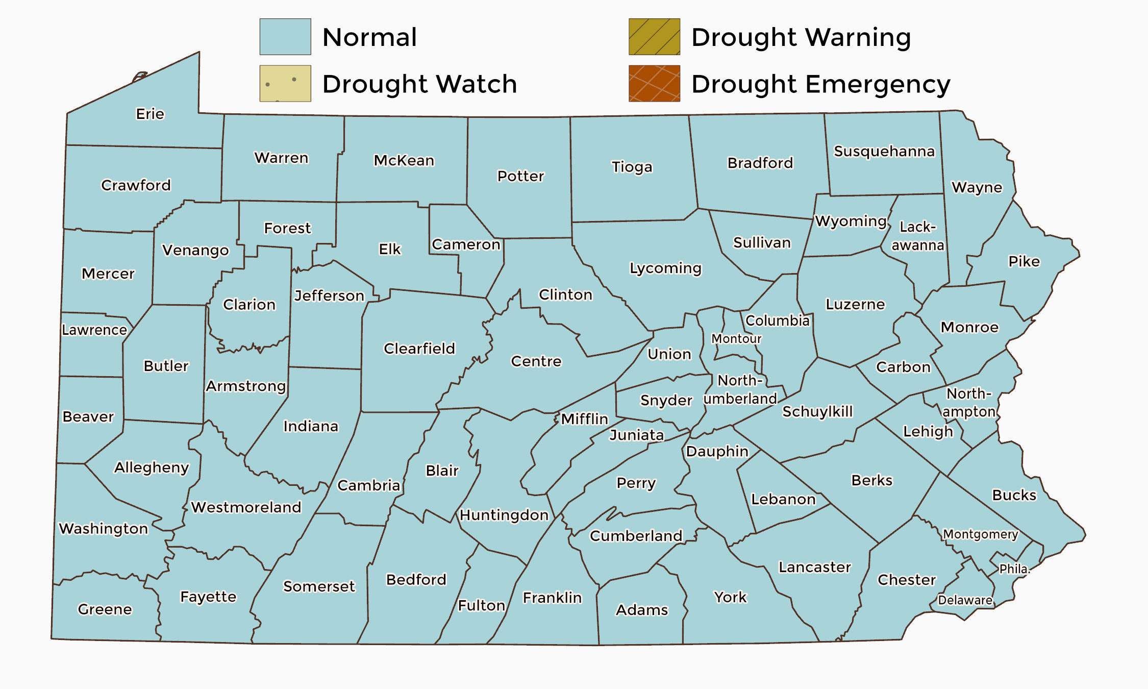
This map is not well thought out. Chester county has enacted a burn ban. Forest fire sign at French creek was moved to moderate last Tuesday or Thursday. We have to get some rain soon otherwise the drought will likely be protracted over the winter.
-
22 hours ago, LVblizzard said:
Clear skies for days and suddenly we get clouds on a night when the aurora is visible. Unreal how that always seems to happen.
weenie rule #1 .... what can go wrong will go wrong
-
1
-
-
On 7/27/2024 at 2:10 PM, Birds~69 said:
Mowed lawn, 87F/DP 55F/ Sunny
Hearing crickets during the day means Fall is approaching...
starting to feel like we are on the downslope for sure : /
-
1
-
-
8 hours ago, ChescoWx said:
Do you think there is a problem with the KRDG Thermometer? Further north in Berks County - higher elevation yet now consistently warmer than the lowest and warmest somewhat urban location in Chester County - Phoenixville. At this rate KRDG might approach KPHL levels soon.

I would say not. Reading is surrounded by tall hills which probably amplifies the heat island effect which is something Philly does not contend with. Could the steel mill and power plants in Reading be interfering too? Its also a much more compact layout than Philly. Plus I would think the heat capacity of the old brick buildings in Reading is greater than modern steel, concrete and asphalt structurers in Philly. Philly rivers and waterfrontage (and likely forested and park areas) are much larger too when compared to Reading.
-
On 7/13/2024 at 11:06 AM, ChescoWx said:
Hey guys thanks to Charlie (Chubbs) I was just able to figure out how to find detailed NCEI adjustments for individual stations in Chester County. I am starting with the original Coatesville 1SW station . Below is an analysis of the actual/raw average annual temperature data vs. the NCEI altered data for Coatesville 1SW from 1894 thru 1982. As discussed before NCEI has multiple reasons stated to support these adjustments. (Time of observation/ station moves/ equipment or siting issues etc.) But of interest the chilling adjustments were consistently applied to the first 71 years (1894 thru 1971) The greatest chilling adjustments were applied to the oldest data with at least 2 degrees F adjustments made from 1897 thru 1922 along with 1931-35 and 1941-45. The end result with the altered data (red) flips what the raw data (blue) clearly shows as cooling trend during those years....to now a clear warming trend. The greatest overall chilling adjustments were made to the October thru December months. But 100% of all months for all years were chilled for April through October. February had the least number of months chilled with 75 of the 89 months while January and March both saw chilling adjustments to 78 of the 89 months on record.

It would be interesting to see this data correlated with forest cover data too. It could help describe some of the discrepancies as most of the area was clear cut.

E PA/NJ/DE Winter 2024/25 Obs/Discussion
in Philadelphia Region
Posted
I concur- we are in weather purgatory right now.