
NorEastermass128
-
Posts
8,922 -
Joined
-
Last visited
Content Type
Profiles
Blogs
Forums
American Weather
Media Demo
Store
Gallery
Posts posted by NorEastermass128
-
-
Since this forum runs on an "AEMATT" theme and since E MA is out of the game through the end of November, I thought I'd kick off the December discussion.
It looks like we have a few cutters and/or huggers to start off the first couple weeks of the first winter month. Rumors of one-eyed piglets sightings near AK too. NAO rising, PNA dropping, AO solidly negative but rising......
What will December bring? Joy or dismay?
-
Winter starts closer to Jan 1 on the coast. Maybe we get a rogue event that melts two days later.
-
2 minutes ago, weathafella said:
Read up. The weeklies are forecasting it.
I saw...hoping that it's off or at least transient.
It's a Nino, so hopefully it doesn't become a permanent resident IF it does develop.
-
 1
1
-
-
As long as we avoid the one-eyed cyclops in AK, I'm good. Here on the coast, I can't get to excited until post 12/20 anyway.
-
7 minutes ago, moneypitmike said:
I vote for posting anything that shows snow.
")
I need an interpretation of this one: AEMATT.
All eastern MAINE all the time

-
Dendrite jackpot again?
Winners ‘gonna win.
-
Norluns are typically interim solutions. I fully expect this to morph into a full blown cutter or Miller B. If the latter, hopefully it develops in time for eastern areas.
-
1
-
-
The 6z GFS is loads of potential.
-
1
-
-
I'd take a 3 day stretch of sun and 50s/60s right about now.
I'm sure we'll get that around Christmas...probably minus the sun of course though.
-
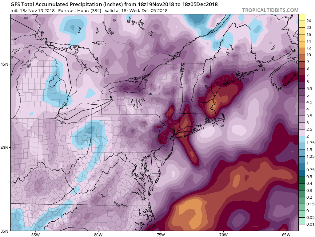
15 minutes ago, Go Kart Mozart said:
18z gfs a tad moist over the next two weeks:

Geez
-
Good shot at several inches near and along the MA/NH border northward tomorrow and no storm disco thread? Are we that spoiled already? Some years flurries in January gets its own 40 page thread.
-
3 minutes ago, HIPPYVALLEY said:
Shut em’ down up in ski country.
Shut em down for 48-72 hrs next week before we turn to a powder keg pattern. Dec may rock.
-
4 minutes ago, mahk_webstah said:
early next week system trending warmer wetter it seems even up here.
Rains to Maine.
-
I have never read so much or learned so much about the great city of Methuen before!
-
 1
1
-
-
1 minute ago, kdxken said:
Rain upon rain . I had an Irish customer this morning threatening to move back to Ireland because the weather sucks around here .
It’s been brutal. So many cloudy rainy days.
-
1
-
-
12z GFS looks a smidge colder?
-
On the phone, but looks like 0z GFS held serve. 850 0C line straddling the Pike.
-
I’m just happy we’re stormy and chilly. Even when it “warms up” we’re only talking average. Winter’s personality starting to show itself.
-
2 minutes ago, CoastalWx said:
For which one? The first one is north of pike and very minor. Second one would be more encompassing and probably nice near 128. Coast would flip to snow.
Thanks. And yeah, I was talking about part 2.
It does look like a 128 special on the 6z GFS.
-
I’m guessing the BL for the immediate coast is cooked again. Midlevels torch for the SE MA coast later on in the event.
-
22 minutes ago, jbenedet said:
I think Tuesday has the look of a (surprise) significant snow potential. Flow is slow—looks Miller B-esque. Cyclogenesis begin south of LI —just need to see more blocking on guidance which looks easily attainable given -NAO/-AO.
Got to slow down the Wed kicker too coming in fast behind it.
-
7 minutes ago, dendrite said:
It's 11/16. Climo is a thaw. Especially in NYC.
Yup. The average high in Boston doesn’t drop below 50F until next Friday.
-
1 minute ago, Baroclinic Zone said:
You talking about this putrid looking thing?
I said potentially.....snow in the air, coating for elevations?
-
1
-
-
Looks like a potentially snowy Monday AM commute on the 12z GFS.
November discussion
in New England
Posted
Not a storm thread, but here's the December discussion thread.
https://www.americanwx.com/bb/topic/51756-december-discussion/
The AEMATT crowd doesn't care about a few moose and skiers getting some paste tonight/tomorrow.")