

usedtobe
-
Posts
8,793 -
Joined
-
Last visited
Content Type
Profiles
Blogs
Forums
American Weather
Media Demo
Store
Gallery
Posts posted by usedtobe
-
-
This is probably already somewhere in the thread but I had saved it and early in the week looked at it. Fun memories from eastern
http://www.easternuswx.com/bb/index.php?/topic/221595-widespread-20-inch-plus-amounts-verified/
-
seems like a split flow happens in almost every big storm....
Pretty much for us, I think new england can get a big one without it.
-
This may be a little nit-picky, but instead of calling it the 850mb line, I would call it the 850mb zero degree isotherm/line. For someone that is truly new to weather map reading that may make a bit more sense since there is more than one isotherm on an 850mb temperature map.

Plus newbies need to know that the 850 temp is at around 5000 ft so the surface temps can often be above freezing when the 850 temps would indicate snow. Also, a warm layer during sleet events often develops above 850mb.
-
Thanks. I wouldn't expect willy nilly changes to the models, so once a year isn't much of a surprise. Plus I'd imagine you need an extended amount of feedback to best change the model. I can just see the predictable anomalies in the models really frustrating for those who maintain the models.
As DTK noted what really makes it tough are two things, one the physics of the atmosphere is very non linear so if you change something like the convective or cloud algorithms/parameterization schemes you don't always know how that might impact other things as condensation within clouds releases and changes the stability, less clouds impacts the amounts of radiation hitting the ground which can change the surface temperature and because they have many different kins of users they can't just make a change without consulting and notifying them of the change and what impact it might have on subsequent forecasts. While HPC the guys that work on the models were really responsive if the forecasters thought they saw something that looked to be a problem. They also have to do a lot of testing of any change before it is implemented. It can be a thankless task when people run down the model that you are working to improve.
-
Great memories, Wes. You certainly were all over that threat. It's funny, though, reading through that tread how the usual fears----suppression vs change-over were popping up 5-6 days prior to a prolific all snow event.
MDstorm
But by 9:00 Am Feb 2nd the models were getting pretty adament except for a rogue run or two of the nam. On the second I wrote.
"I talked to my friend Rich Grumm and he noted that the ensembles were showing an 90% chance of a foot of snow over my house" Ensemble systems often do not have enough spread but from that point on the ens system was emphatic about getting a major snowstorm. That's really rare.
-
I love going back and reading the old Eastern threads. It lacks something with all of the hotlinked images missing, but the raw excitement is fantastic.
I have some of the images from then though I think I've blown some of them away. It is fun reading the threads. I looked for the Dec 19th thread but couldn't find it. That was an exciting period when we all got along well because optimism and weenism ruled.
-
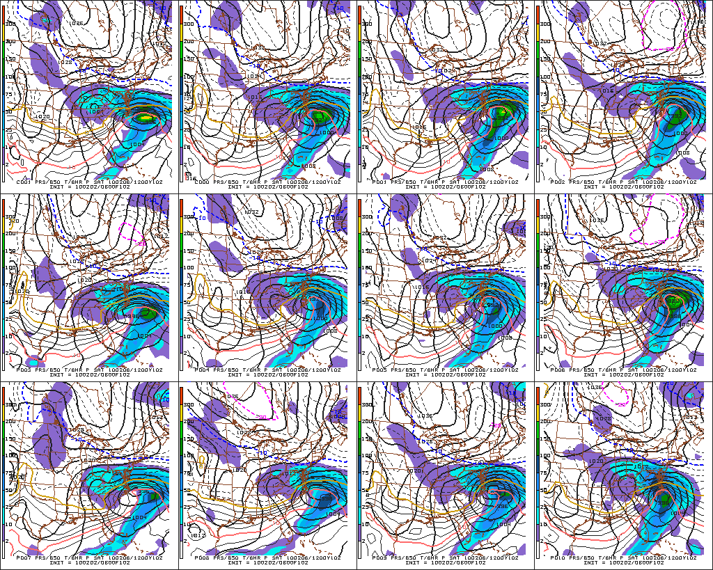
Absolutely excellent read and a great memory. Did you do the same thing over there for 09-10 Feb?
I think so but I wasn't as optimistic for dc for that storm since it was a miller b evolution. I don't think I saved that thread, only the dec and feb 5-6 ones.
-
Here's my eastern tread leading up to the storm. I doubt we'll ever see another stretch comparable to Jan 31 thru Feb 11
-
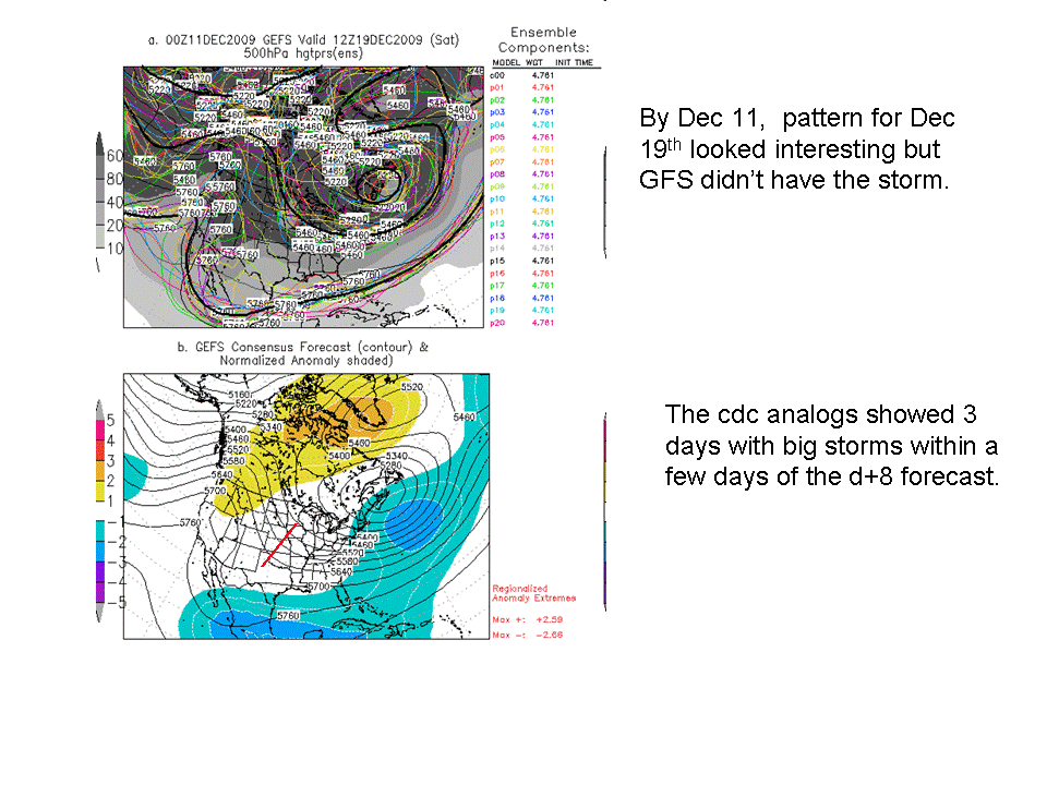
I remember really being stoked by pattern and talking quite awhile about the potential for a KU storm since the pattern was looking so favorable. By the 11th, The D+8 CPC analogs identified 3 KU storms within several days of the centered mean.
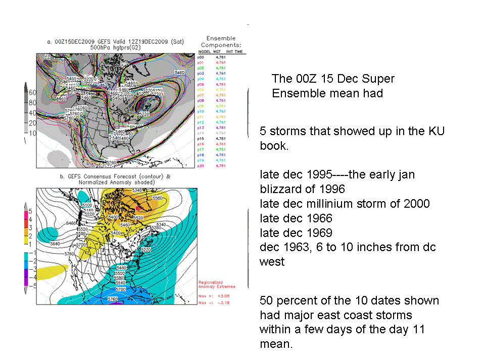
By the 14 or 15 the number had jumped up to 5 inclduing some really famous events.
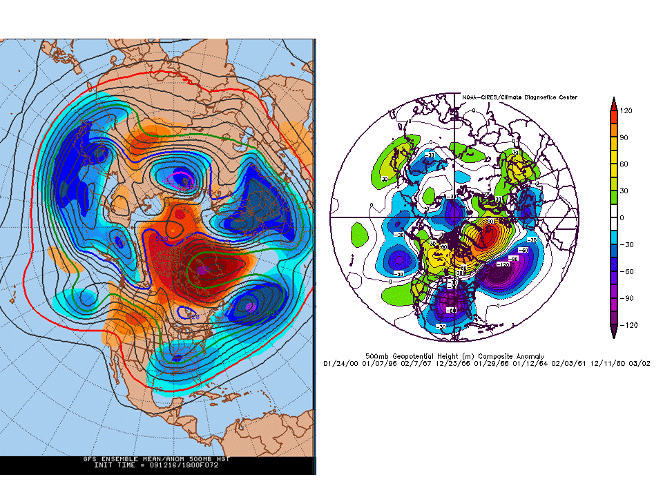
By 72 the esnemble mean pattern was almost identical to KU storms that produced over 8 inches at DCA.
It was actually a storm I was bullish about despite having a non-bullish rep.
-
the euros might disagree

Yes as would the ukmet guys as their model scores better than the GFS. Most offices I think have journeyman and interns so there is a place to learn forecasting. Plus, I think the training of the NWS is better on average than in the private sector. There are training modules and the Weather Event Simulator (http://www.wdtb.noaa.gov/tools/wes/index.htm) where they can work on canned forecast problems.
-
Yes, that was the reason that they changed the program but, I would say that the new program is even better for student interns. I'm currently in the SCEP program but will be converted to this new internship program sometime in 2012.
http://www.gpo.gov/f.../2011-19623.pdf
From the link above...
"The Internship Program is for current students. It will consolidate provisions of the Student Educational Employment Program (SEEP) into a new student internship program designed to provide high school, vocational and technical, undergraduate, and graduate students opportunities to be exposed to the work of Government through Federal internships. This program is designed to attract the interest of students enrolled in a wide variety of educational institutions, with paid opportunities to work in agencies and explore Federal careers while still in school. Agencies may convert Interns who successfully complete program and academic requirements to any competitive service position for which the Intern is qualified, but they are not required to do so. It is expected that, even if an agency does not convert an Intern, service in the Internship Program will increase the likelihood that the Intern will consider applying for a Federal position at some point in the future, based upon the exposure to employment in the Pathways Program."
To complete this program the interns must work 320(8 weeks) hours if the job is related to your career field or 640(16 weeks) hours if it is not related. They will also have to obtain a degree. After that it will be up to the employer whether or not to non-competitively convert them to a position. Before STEP interns were not allowed to be transferred into civil service but now with this program any intern can get a job in the civil service. The other difference is veterans will get there preference points for applying to student positions as long as they are students. Another difference is in the recent graduate program(Use to be FCIP). Regular students can get jobs under the recent graduate program no later then 2 years after completing college. While the Veterans will have up to 6 years after college to get into the recent graduate program.
So, for anyone that doesn't think that this program is better then the SCEP/STEP/FCIP I would have to majorly disagree. It also gives student veterans a bigger advantage over regular student interns. While still giving regular students a chance to get in the government.
Good for you, do you still live in Calvert County?
-
WVclimo saved this from the thread I had written about the event. It was fun rereading it.
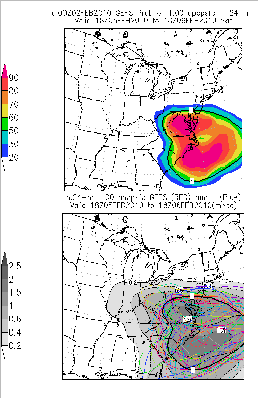
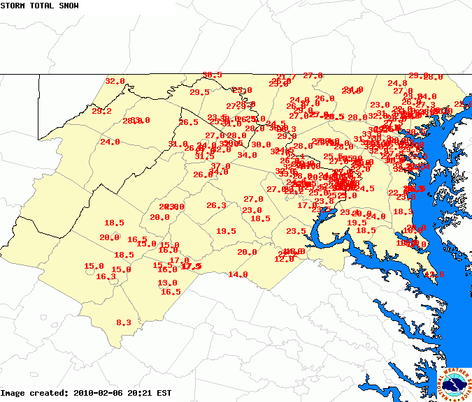
This will be a truly historic storm and has very good shot at breaking the dca snowstorm total for reagan national airport. Why am I so giddy. Well, I talked to another old time met and he was saying he thought the warm advection between HAT and DCA was the same as during the 1979 event which is the current reagan national record. Also, the 06Z nam and 06 gfs both have more than 2.75 inches over dc. Normally I might discount them, I suspect the nam's 3 inches is too high but do think that over 2.5" inches is likely. the storm with that type of moisture was the feb 2003 event except this one will be all snow over dc, that one mixed. Why am I so sure this will be snow, it's teh confluence, this one's confluence is much stronger than that one. That storm produced a large area of 20 plus inches of snow across the dc area into parts of delmarva, this one should too! That storm produced pockets of ovr 30 inches, this one probably will too. The one difference is this one will probably have the 20 inch plus amounts across PG county and at least the northern half of calvert.
This is going to be a truly disruptive storm. I've filled one of my bathtubs with water and am putting lots of perishables in a cooler that I'm going to put in the snow so I don't have to open the freezing or fridge if we lose power. I think that's a possibility.
Phl still looks to get heavy snow, JamieO is still in the tight gradient. Nothing has changed from last night except the models are even wetter.
-
NAM archives: http://beta.wxcaster...odelArchive.cgi
GFS archives: http://beta.wxcaster...odelArchive.cgi
RUC archives: http://beta.wxcaster...odelArchive.cgi
I think those only go back to april. This site goes back anc catches both the Dec and Feb storms.
http://charlie.wxcaster.com/cgi-bin/namModelArchive.cgi
http://charlie.wxcaster.com/cgi-bin/GFSModelArchive.cgi
I had already posted them once but no one reads through threads.
-
By 138 hours all but one GEFS member was forecasting a major storm.
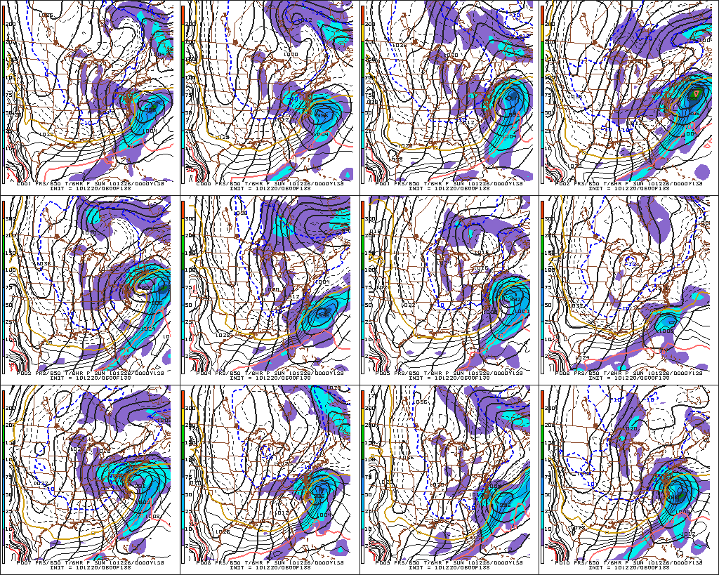
By 102 hours every member had a major snowstorm
90% of the GEFS ensemble members started showing double digit snows.
BY 120 hrs the eruo had brought a 500 low just to our south and made it a big storm.
By 72 hr the nam looked great and kept getting wetter each run. I have some of those maps but there are too many to show. I wish I had my thread from eastern on it as the day before it started as I changed the headline to read widespread 20 inch amounts likely. I sounded like JB. I got downright giddy.
I also remember that the D+8 superensembles kept spitting out 5 6 inch or greater storms most being KU storms and at 48 hrs the CIPS analogs picked 1983 as its top one.
It was one of the best forecast storms I can ever remember. Maybe the best.
If you are real geeky. Her's a location where NAm forecasts are archived. You can look at its forecasts for the event. Basically pretty darn good.
http://charlie.wxcaster.com/cgi-bin/namModelArchive.cgi
you can also get the gfs
http://charlie.wxcaster.com/cgi-bin/gfsModelArchive.cgi
]
-
I remember posting about it and Jason quoting me on the Capital Weather Gang site and my neighbor telling me that he had seen me quoted. I think I said something like we hadn't seen a storm like this one before in dec for the dc area. Beyond that, I remember being excited that my part of Calvert county stayed all snow.
Remembering Snowpocalypse -- 12/18-12/19, 2009
in Mid Atlantic
Posted
I thought i interesting that the CIPPS analogs identified 1983 as the top analog for the dec 2009 storm and the feb 6th 2010 one. The 2010 storm would have had the dec event as a top analogs but it was not yet int he data base.