-
Posts
8,793 -
Joined
-
Last visited
Content Type
Profiles
Blogs
Forums
American Weather
Media Demo
Store
Gallery
Posts posted by usedtobe
-
-
1 minute ago, MN Transplant said:
HRRR at range and 3km NAM are bone dry
This system always has had a tough road to travel. The upper trough is too round and the low is too strung out to so it was always hard to believe the 18Z NAM and the earlier GFS models. Still there was enough uncertainty to not completely gainsay it. I'll be satisfied with mood flakes like the 00Z model has.
-
 14
14
-
-
0.52 yesterday. I was in a severe thunderstorm warning but didn't have much wind.
-
0.19" here in northern Calvert. That will teach me not to give the hurricane model radar forecasts much credence at our latitude.
-
 4
4
-
-
11 minutes ago, CAPE said:
HRRR has my yard on the NW edge. It could be right, I suppose.
The HRRR gives me nada as the Virginia convection lifts north and the convection closer to the storm stays east. The high res models are certainly different. the 12z HIRES nam misses me to the south and east. I guess radar will let us know which model grouping is correct. I don't have much of a feel for the system as I don't trust the HRRR. I do find the hires NAM discouraging however.
-
 2
2
-
-
It will be interesting to see what the euro does. On average, I think it has generally been west of the GFS with the storm. Not sure whether that's a bias or it being better as I can't remember what it did last summer with tropical systems.
-
 7
7
-
-
Measured around 1.5" of sleet at multiple points on my sidewalk. The most sleet I've had since 1994.

-
 18
18
-
 2
2
-
-
Rain at 7AM turned to snow by 7:15. The mulch and grass have caved with my temp at 34.3.
-
 6
6
-
-
-
2 hours ago, leesburg 04 said:
So is the euro all by itself showing a massive storm? Doesn't Ji have a peer reviewed theory on that?
I think the 00Z UKMET if extended would be good. It has the primary low in Kentucky and the secondary forming in eastern NC with you under a pretty good wedge.
-
 12
12
-
 2
2
-
-
Just now, IUsedToHateCold said:
If it's raining in Winchester I assume the mid levels are too warm. I would also assume that since it's rain (not sleet) that they are pretty warm indeed. Can rates really overcome that?
I really just don't want to get my hopes up for snow if this is just going to be freezing rain.
Rates alone can't but if the atmosphere above is dry, as the snow melts and evaporates the column can cool and help turn the rain to snow. That's what the models have been advertising.
-
 8
8
-
-
21 hours ago, stormtracker said:
This is the post i was waiting for. It’s gonna snow y’all.
Don't we wish. The Euro slid back but not as far as the UKMET. The 06Z Euro ensembles only give us a 10 to 20 percent chance of 3 inches. The 06Z GEFS loves us. Why do I think it better to be with the UKMET and Euro? Still too early to give up. I still write for the post so that limits me from saying too much until we post our article.
-
 3
3
-
-
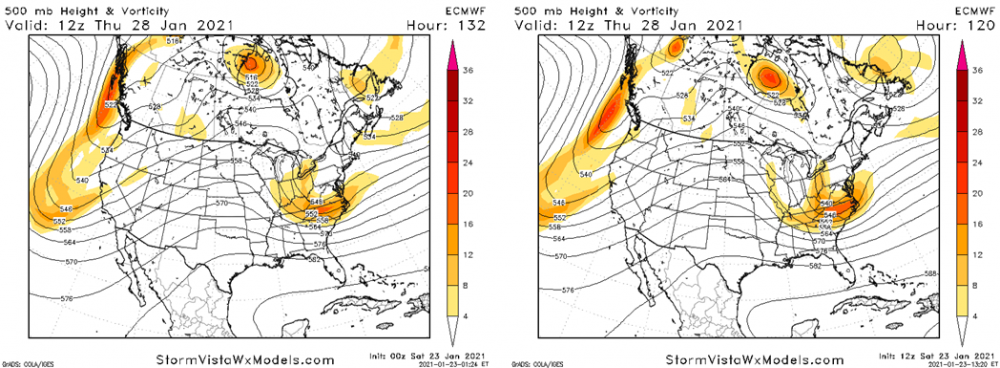
 It is pretty good step towards the GFS. Below is a comparison of 00Z 500h and the 12Z. Note how much more ridging takes place ahead of the vort and associated trof and what has happened over Maine. The latter has relaxed allowing more room for our approaching trough. If it relaxes a tad more we might get development a little farther west and more precipitation. There is that pesky impulse ahead of the trof, if it were to minor out quicker that would also help.
-
 19
19
-
 8
8
-
-
The 18Z GFS sure is encouraging. It's not back to yesterday's Euro, but gives me 11".
-
 14
14
-
 1
1
-
 2
2
-
-
4 minutes ago, DCAlexandria said:
UsedTube is back! Love it.
Well occasionally. Unfortunately, the Euro ensemble mean for the 28th looks pretty bad. I haven't given up on the 28th but would feel better if the Euro and UKMET were on my side than the Canadian and GFS.
-
 3
3
-
 1
1
-
-
9 minutes ago, psuhoffman said:
It was an improvement from 0z. The track of the upper feature is perfect. It dies but follow the precip associated with that and it’s headed right for us. Problem is it was too weak. But that’s not some huge change. It needs to be slightly more amplified with that exact track. The surface low is a response to arhat upper low do don’t worry about that. If that upper feature was stronger you get a stronger more tucked surface low and that precip coming from the west doesn’t die. There is a critical mass type level of amplitude the wave has to reach and this run was just a bit under it.
One of the problems that is just as important as the weaker ridge behind it is the upper pattern over New England won't allow enough room for a shortwave ridge to form ahead of the trough which keeps it from strengthening and in a sense shears it a bit while also reducing the upper level divergence in advance of the trough compared to what would happen with more room and a better shortwave ridge. That prevents our surface low from getting very far north. At least that's my take. Weaken or shove the troughiness over the northeast a little farther east and we'd be OK. At least I think we'd be OK. Slow the eastward movement of the trof would help do the same thing.
-
 10
10
-
 4
4
-
-
1 hour ago, chris21 said:
I thought the GFS looked somewhat different than the Canadian for the first storm. Am I missing something here?
It does differ but still offers no snow, looks like freezing rain. It does have another possible weird looking snow event later in the month but the surface looks really strange. The euro does offer some front end snow but with the surface track and development its got, I'm not sure I buy but hope it's right.
-
 2
2
-
 4
4
-
-
25 minutes ago, stormtracker said:
Yup suppressed...which isn't what I was expecting. Guess it's better than norther warmer rainer. Let's see if the GFS it's back to being on it's own or is it sniffing something out.
Unfortunately the Canadian also is onboard the GFS express. It looks much different over Canada at 500h but not enough. I'm supposed to be a Winter weather Expert and the last two years, there has been no storms to write about.
-
 2
2
-
-
Jason and I will have a post on it coming up. Right now we're playing the probabilities for various accumulations lower than suggested by the eps POPS or GFS as there were lots of different evolutions shown on the ensemble stamps. Plus, we're 4 days out and we live around DC.
-
 13
13
-
 3
3
-
-
13 minutes ago, high risk said:
The parallel GFS had statistically significant synoptic range improvement over the ops GFS in the medium range over the full course of the retrospective runs. But that certainly doesn't preclude it doing worse on any single event. I wish we were able to run it more than once per day right now.....
That's what I thought I remembered from yesterday's Sterling winter weather workshop.
-
 1
1
-
-
4 minutes ago, high risk said:
They do run tend to a bit low (especially when the ground is relatively "warm", but they're so much better than 10:1 maps in any event in marginal thermodynamic environment.
I honestly don't blame WB or TT. The problem is that NCEP doesn't generate true snow accumulation output for any models except RAP and HRRR, so it's up to the user to assign and apply an SLR. This is going to be addressed going forward.
Geoff, How does the Parallel GFS do compared to the current version. I noticed the 00Z parallel from last night had much lower pressure over the Great Lakes than the 00Z operational so it forecast all rain across the area. It was quite a bit farther west with the secondary. Despite the overly rosey Eruo ensemble snow probabilities, the lows were all over the place, lots of spread.
-
 2
2
-
 1
1
-
-
7 hours ago, psuhoffman said:
boom
Ji will be happy...
naw who we kidding
IF I counted right the 06Z Euro ensembles have 12 of 50 members showing snow in the 14th/15th time slot.
-
 18
18
-
 1
1
-
-
0.48" yesterday evening.
-
 1
1
-
-
Got my tomatoes in last week. Will I need to cover them this weekend? Going to be closer than I'd like. Right now I'm glad I live east of the city.
-
 2
2
-
-
13 hours ago, Baltimorewx said:
I think you’re a fraud. You’re literally expecting a computer to model a chaotic global atmosphere perfectly. Can you just stop, Jesus. If you don’t want to discuss long range weather and the models, then don’t come on the forum. Some of the best snowstorms were sniffed out more than 5 days out.
Yep, 90% of the ensemble members gave us 1.00" liquid as snow 5 days in advance of the the FEB 5, 2010 BLIZZARD. Also, the models keep improving. A 60-84 hour forecast of 0.50" precipitation amounts are now better than 12-36 hour(day 1 forecast) from the 1990s. You're right about chaos, makes forecasting tough but also suggests some patterns are more predictable than others.
-
 9
9
-
 2
2
-


January 28-29 2022 Miller abcdefu Storm Obs/Discussion
in Mid Atlantic
Posted
My snow today, 4 inches on my brick wall at the back of our driveway. Very pretty!