

usedtobe
-
Posts
8,793 -
Joined
-
Last visited
Content Type
Profiles
Blogs
Forums
American Weather
Media Demo
Store
Gallery
Posts posted by usedtobe
-
-
A coating on the driveway but barely,
-
The high res NAM is a bummer for folks around DC. delays the precip long enough that the low levels warm. It's out of its range but that is a scenario that I could see happening as I've seen it happen occasionally in the past.
-
2 minutes ago, PhineasC said:
I just got NAM'ed.
So did I now everyting is north and west of me.
-
 2
2
-
-
18 minutes ago, MN Transplant said:
Cough.
My fitbit heart rate was elevated for the entire 4th Q and OT.
I thought the Viking's play calling in the 4th quarter was pretty bad. They kept running the runs mostly were going no where. Cousin's success during the year and in throwing the perfect pass at the end of the game illustrates how poor Allen was at evaluating talent. I never understood why they frnachised him twice instead of ponying up at the end of his original contract.
-
1 hour ago, WinterWxLuvr said:
I wonder which is more likely. Might have to wait to see how the radar develops. My gut says precip from that direction tends to arrive a bit earlier than is forecast. We shall see
I think that's true on average.
-
7 minutes ago, WinterWxLuvr said:
The GFS is really fast. It has precip on my doorstep by 9 am, about 2 hours faster than the NAM. Let’s hope the gfs is right on start time and the NAM is right on end time.
at least they both have a thump, hope that is right
-
5 minutes ago, Cobalt said:
GFS Kuchera cuts totals in half for most, but still rather optimistic numbers
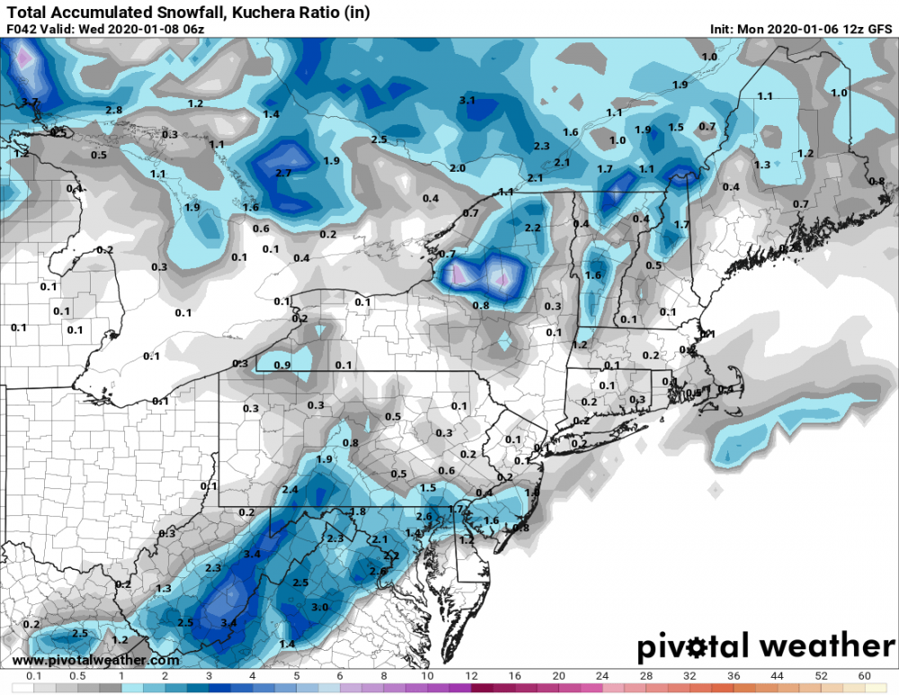
Look at the pivotal weather snow depth product, it usually provides a more realistic forecast with marginal temps.
-
 3
3
-
 1
1
-
-
11 minutes ago, high risk said:
NAM actually takes most of the area up to 40 tomorrow ahead of the precip (low to mid 40s in southern MD) but has strong cooling as the precip arrives to bring most areas down into the lower 30s.
I think the dewpoints tomorrow at 12Z are forecast to be in the upper teens west of the city and around 20 in the city so the cooling looks real especially if we get close to 09.25 " in 3 hours or so. That's a pretty good thump. Still, I'd only go with a coating to an inch aroudn the city and maybe 1 to 2 out west even though the models are showing the most precip south of us.
-
3
-
1
-
-
-
28 minutes ago, Ralph Wiggum said:
If you loop the ens means that central Pac ridge looks like the storm on Jupiter. It never moves.
And that's the big problem with the pattern, the ridge position and the location of the max positive anomaly within it. It's not favorable for moving the trough in the west. Of course, the ensemble mean still could be wrong way out there in fantasy land but if it is mostly right and we don't get a hit in the cold window earlier in the month, we probably are screwed through mid January.
-
2
-
-
4 minutes ago, frd said:
From Ventrice regarding the high amplitude ridge set to build over the North Pac into the Aleutians.
Keep in mid this development, and the progression from there is way out in time.
Looks to me like there is one window around the 7th or 8th with the cold and then troughiness approaching the east coast. I'd call it partially ajar, far from a perfect pattern but one that could give us something with luck despite the ;latest GFS run taking it away. Still it's probably a long shot but at least its a shot. If that window closes, we may have to wait until the second half of January as the Pac ridge is too far west to supply anything but a negative anomaly in the west. The EPS does build the ridge into ak but towards the end of the run starts pulling it back again. That's so far outside of the skillful range who really cares. This pattern suck if you are a winter wx expert that focuses on DC.
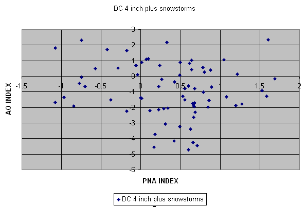
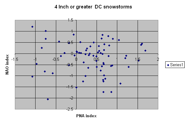
I looked for the AO/4 inch snowstorm graph hoping I had it on a thumb drive but it's not. I have it on my old PC so I'll look for it down the road. I need to get all my old excell files on the new PC.
-
6
-
-
31 minutes ago, psuhoffman said:
It’s not the bouncing around. It’s that it starts to intensify and consolidate. Opposite of what we want.
Goes from this...

to this....

Yep a positive AO/NAO and EPO, not a very inviting look for snow around DC.
-
1
-
-
14 minutes ago, psuhoffman said:
Of course he is...
It bears some small resemblance to the pattern a couple weeks before as it was just developing, not right before. And saying that is irresponsible because all people will hear is “big snow coming” when even if that’s right the pattern might not progress the same as January 2010 did and in reality we could get that type of block and probably wouldn’t get that outcome again. It would likely snow but I bet if we got that pattern 100 times only a few went that well. That was a combo of epic pattern AND crazy stupid luck.
Plus, the spaghetti plots are all over the place so there is probably no skill at that time range even for the ensemble mean. My guess is there will be more amplitude somewhere but where makes a huge difference and some ensemble members like the operational, others are much different from it.
-
17
-
1
-
-
Whitened the top pf the car and some leaves. Sounds like i was minned compared even to Prince Frederick
-
3
-
-
On 7/29/2019 at 11:06 AM, yoda said:
Didn't @usedtobe work there? I think he is retired now though... his name is Wes btw
I did work there but retired in 2004 though I worked for several years part time as a contractor til around 2009. I know some of the forecasters but no longer know the bosses. I don't even know the office phone number. I'm not sure how hiring works anymore.
-
.67" in the gauge at 9:30. Last night at around 2:30 or so there was a velocity couplet in Clavert county but i don't see any reports of a possible tornado. I did lose power for about an hour.
-
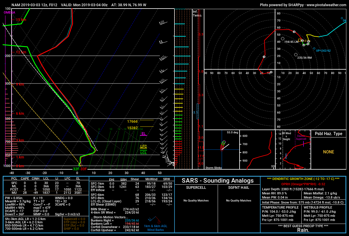
Here's the sounding from the NAM at DC at 00Z. Is it sleet or rain? it's right at that threshold and the sounding suggests folks just to the north and west will probably be getting sleet courtesy of PivotalWx.

-
3
-
1
-
-
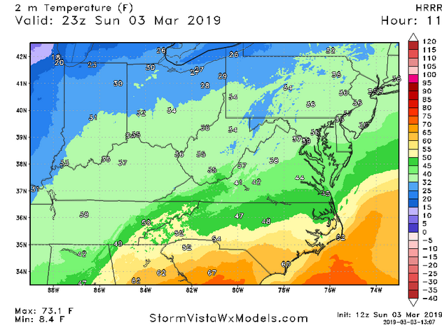
The 06Z Euro has the 2m temp at 34 at 00Z at DCA, The 11Z HRRR has it at 39. I've not been a big fan of the HRRR. My question to my friends at EMC, are there any verification of the HRRR 2m temps and is there a high bias? oops I showed teh 23Z but the 00Z has the same temp.
-
41 minutes ago, leesburg 04 said:
CWG just cancelled the event...just conversational sleet/snow changing to rain.
Not for you, probably go with 1-3 for you and 2-4 in Winchester. I'm certainly not impressed for DC.
-
1
-
-
3 minutes ago, LP08 said:
Gfs has flurries/sprinkles. Not much excitement in this threat at the time
You need to root for mesoscale banding like the NAM has.
-
Just looked at the SREF. I know most here think it useless but you can use it's own wet bias to look at possibilities. Only one member has more than 1" of snow. The mean of all members is less than 0.10" liquid thru 18Z Friday and that includes one that gives almost 0.40".
-
3
-
-
Just now, stormtracker said:
Wes, it sounds like you don't believe the NAM. I could be wrong though.
If the Euro comes back wet, then I'd buy give it more credence. Without the 0.30" liquid, I doubt the temps would be that cold.
-
14 minutes ago, high risk said:
NAM has some very good 850 mb speed convergence with a modest southerly jet. The previous wetter runs of the GFS had the similar jet structure, but overnight runs have shown a weaker and more veered low level jet.
Good point. I still have a hard time buying it. I could see 0.10" liquid but 0.30" is hard to believe. It could be right, but I'd bet against it.
-
1
-
-
Just now, LP08 said:
I am certainly not someone in the know but it seems to max some frontogenesis over the area for a few hours. It’s probably wrong as you stated with the main forcing well south.
Always good to to see you pop in Wes

Least that explains it.


January Discobs 2020
in Mid Atlantic
Posted
got to 19.4 last night,