

Cashtown_Coop
-
Posts
3,380 -
Joined
-
Last visited
Content Type
Profiles
Blogs
Forums
American Weather
Media Demo
Store
Gallery
Posts posted by Cashtown_Coop
-
-
Day 2 from SPC

-
 1
1
-
 1
1
-
-
36 minutes ago, canderson said:
No sun? There is barely a cloud in the sky here. Some really light whispy stuff, but very minimal.
No sun here yet. It’s been a real low ceiling with a high of 72 so far
-
31 minutes ago, Bubbler86 said:
Between the rain and no sun, today is a good day for yards.
And golf courses
-
 2
2
-
-
5 minutes ago, Bubbler86 said:
I did not hear anything. LOL (Sleeping)
Quite a lightning show. I received 0.65” of rain and a gust to 25. Nothing that exciting except the vivid Lightning.
-
1
-
-
@bubbler86 incoming !!!!
-
45 minutes ago, Bubbler86 said:
18Z HRRR and 3K are very well aligned in direction and location of "the low" tomorrow AM. Less MCS like on both though the HRRR has a long period of rain. Both are limited qpf wise for the LSV. NAM12K has conceded west but is more MCS like.
Best case scenario for me would be a period of steady rain.
-
31 minutes ago, Bubbler86 said:
18Z a tad south and west.
GFS 18z

-
1
-
-
14 minutes ago, CarlislePaWx said:
I don't think I've ever seen a low pressure (in June!) that looks like a clipper come down from the northwest and slice through PA while central pressures drop to the low 990's. It looks so weird.
Another thing I haven't seen (though I'm sure it's happened before) are such widespread temps over 100 in so many states. It looks like all of Georgia is over 100 degrees at 2:00pm Tuesday. Absolutely crazy...lol.
BTW, I've had a trace of rain here since midnight. Over the last 3 days I've only had just under 0.25". Low this morning was 56, currently 65 with the sun trying hard to make an appearance, yet still overcast.
Nam shifted way west from last run. Some big rain numbers showing up

-
1 hour ago, Bubbler86 said:
This is the big boy threat for flooding rains but it keeps moving ever so slightly North in it's trajectory. The LSV was too far east a couple days ago...now borderline too far west.

A true nowcast event. Looked like euro was well west. Time will tell
-
1
-
-
1 hour ago, Bubbler86 said:
The GFS is a rain fest Today-Tue. Not a forecast just observation. Ends with a Clipper soaker and the GFS keeps the ultra cold look for later this month.


I watched weather world 12 days trends and it showed no big heat
-
11 minutes ago, Bubbler86 said:
I think the message was mixed a bit and the model runs that dried today out were frustrating. I think most of the D word was said in jest. It has been dry though. Twice a day waterings required.
If you’re watering twice a day, you’re not putting enough water out the first time. Radar does look good for us
-
21 minutes ago, Bubbler86 said:
A wet Saturday morning just getting under way. Radar looks juiced. Have not check modeled direction yet. Hopefully a slow soaker.
Edit-Nam has about one half inch getting into Harrisburg with more south. Rgem has the rain riding the M/D. Others in between with much of the lsv getting something. Hrrr has up to ..05 inch lsv up to Harrisburg area A few lollipops higher. Wet most of the day.
All I herd this week in here was drought incoming dry weekend lol. Someone ends up with 1”+ next 48 hours in lsv
-
6 minutes ago, Bubbler86 said:
#plushyardsforfranklinandadams
Plushgolfcoursesadamsyork
-
1
-
-
1 hour ago, Bubbler86 said:
12Z's got a lot more rainy for the weekend.
Some over 1" totals
Let’s do it
-
40 minutes ago, mahantango#1 said:
1.28 rain overnight.
Dang. Wish I had that at the course. Only 0.05
-
1 hour ago, Itstrainingtime said:
I got far less rain than a lot on here - .21" was my total. Areas under trees remained mainly dry.
0.61 for me
golf course only managed 0.21
-
6 minutes ago, Bubbler86 said:
Wow, we are still over .2 here.
Training time for the win. VP2 now reading 0.61”. I’ll get official number in morn but that was a lot more than I excepted

-
Closing in on .40”. A well welcomed rain
-
1
-
-
1 minute ago, Itstrainingtime said:
That band of showers in western Adams and Franklin counties might deliver something here in an hour or so...
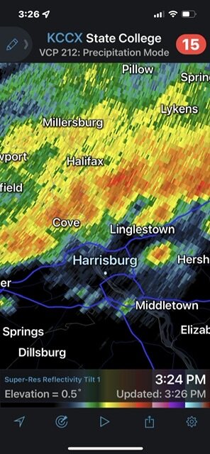
Radar returns are light but it’s putting it down
-
1
-
-
2 hours ago, Bubbler86 said:
We just had a gust to 34. Out of the SE.
only 69 at 12:00. My wind is staying below tropical storm force. Gust to 14 so far today
-
PA state climatologist recognized Capitol City Airport with 97 degrees for highest temp in May. Crazy

-
6 minutes ago, Bubbler86 said:
Yea, I blamed the people who deserved blame, LOL. MU Heat Wave wise (3 day heat wave) here are the people who made it and did not for the stations I could find somewhat near by.
Made It: MDT, LNS, CXY,
Did not: HGR, MUI, MTN, OQN, MQS
I hit 90 for like 5 min the one day but mostly upper 80s.
-
6 minutes ago, Bubbler86 said:
I am still on .1 from this AM.
Slipped north of you. Good hit here. Course received a little drink as well.
-
12 minutes ago, canderson said:
Story of the spring. It’s dry here. Really need rain. Likely won’t happen. Again.
I wouldn’t give up hope yet. Plenty of time for line to sag south. I believe the best chance for me is the line back in Pittsburgh going off Trajectory


Central PA Summer 2022
in Upstate New York/Pennsylvania
Posted
The only thing I root for is rain. Wind just means more cleanup