

Chicago WX
-
Posts
18,285 -
Joined
Content Type
Profiles
Blogs
Forums
American Weather
Media Demo
Store
Gallery
Posts posted by Chicago WX
-
-
1 hour ago, Hoosier said:
Figuring out the exact placement of these screw zones is a bit challenging. Assuming they are real. Still some time to get a more filled in look I suppose but it's running out.
Hi. Models have been very consistent in the sucker hole. IKK just happens to be pretty much locked in it. That’s why I think a Watch for here is kinda silly. It’ll be an advisory at best for the LOT CWA portions, south of I-80. North of there, different story.

-
Total mess here this morning. Had freezing drizzle that has now turned to light snow. Everything a sheet of ice. Going to be an awesome day at work.

-
6z RGEM is lol. Rains to LAF. HIRES models are being ridiculous.
FGEN plus LES will make for a nice storm for Chicago. Have to have some perspective. Alas, there will be a screw zone of sorts that gets stuck in the middle. Unfortunately I'm sitting dead center in it right now.
But, I'm hoping to squeeze out 2-4", which would be a nice refresher.
-
 1
1
-
-
28 minutes ago, michsnowfreak said:
I would not call anything consensus right now. There was more of a consensus several days ago, I get a kick out of how the models can be consistent with each other far out, then as you get closer to the event they go haywire and in different directions. 6ZGFS as already corrected North from 00z as well as GEFS. Todays runs should be...interesting.
Consensus is in the eye of the beholder I guess. For MBY anyways, pretty clear move in the models..and not for the better.
And IMO, the ensembles have been almost useless. Especially the EPS. Consistently too far north up until this point, but they are lower skill. Alas, storm hasn’t happened yet. We watch and wait...
-
1
-
-
Hard to ignore pretty good consensus now. Not that there can't be more changes, good or bad. Regardless, looks like a pretty good storm for the OV crew.
Just hoping for a couple inches up here, a refresher of sort.

-
1
-
-
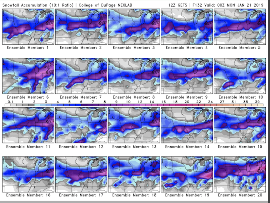
12z GEFS individual member total snowfall thru 0z Monday (10:1 ratio). Purple shading starts the 6" and up totals.
-
 1
1
-
-
7 minutes ago, AppsRunner said:
When should I post the JMA and NAVGEM? I should probably dig up my old links to the Brazilian and KMA too.
Checking my weenie model folder...and the FIM is not running due to the shutdown.

-
lol, I guess I was wrong with FV3. Does some weird jumping around with the slp between 96 and 114 hours...almost looks like it jumps the slp with convection from 102-108...but still manages to drive a 999mb storm into SE Ohio. I'm punting that solution verbatim. End result would probably be more favorable for N IL, IMO.
-
1
-
-
Way too early to freak out for sure.
i can only see it thru 96, but the 12z FV3 certainly doesn’t look south as alluded to earlier. But maybe it goes to crap after...
-
29 minutes ago, RCNYILWX said:
The 12z GFS has the longest duration single snow event I've ever seen modeled here next week.
Sent from my SM-G965U using Tapatalk
27 minutes ago, Chicago Storm said:That system on the GFS next week has snow in Chicago for 2 3/4 days. 15-20” that run.
Would put back to back big dogs in play.
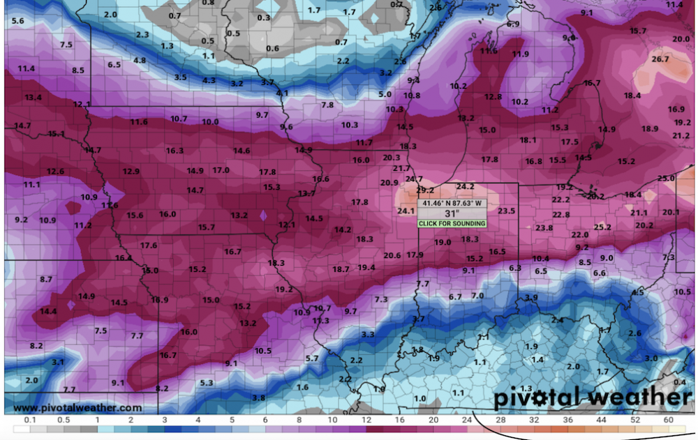
.Just for fun, 12z GFS 10 day total snowfall (kuchera). Congrats Hoosier...
-
1
-
-
-
Lots of fun cherry picking individual EPS runs. I'm partial to #2.


-
1
-
1
-
 1
1
-
 1
1
-
-
Some pretty tasty 12z EPS members. Few clunkers. Really like this one for the sub at this point.
Also looking ahead to the storm following this one. I think that one has potential for something really neat. But first things first.
-
3
-
-
12z Uncle. Yes please.
-
3
-
-
25 minutes ago, Hoosier said:
Different setup but locally this reminds me of that January 2009 storm in LAF in which you painstakingly crawl your way toward a semi-respectable total.
Enjoy the snow.

The one where IND got like 12.5”? I remember that one.
And I’m enjoying. Out working out in it!
-
Coming down in buckets here right now. Flake size is pretty good too!


-
2
-
-
Pounding. I smell an overachiever, relative to my expectations anyways.
-
2
-
-
LSX (St Louis) CWA
0520 AM     SNOW             WILLIAMSBURG            38.92N 91.70W
01/12/2019  M13.5 INCH       CALLAWAY           MO   TRAINED SPOTTER
-
11 minutes ago, cyclone77 said:
Looks like we're closing in on an inch here. HRRR/RAP show over 1/2" of precip, so we look to make a run at 6". Always nice to see things trend in the good direction in the final 12hrs instead of the opposite lol.
You debbed your way to 6". Congrats!
")
Radar returns crawling north around here...snow literally knocking on the back door, lol...but we are getting some flakes with whatever moves overhead. Still like somewhere in the 3-5" range for IKK...
-
1
-
-
12z RGEM brought the 0.50” line north of IKK. That’s nice.
-
1
-
-
12 minutes ago, ams30721us said:
Yea, looks more like the FV-3. Brings heavier totals 3-5"+ totals right to I-80 corridor.
Painfully close for here. Alas, I’ll take 3 and change.
Not a perfect match, but snowfall distribution with this one looks similar to the March 24-25, 2013 storm. SPI probably isn’t getting 18” and LAF close to a foot, but fairly similar.
-
1
-
-
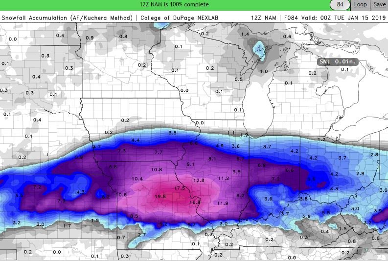
12z NAM improved for quite a few. Brought higher totals northward for central IL, the QC,...and farther east for the IN and OH crews. Jackpot is just west/northwest of STL.
-
1
-
-
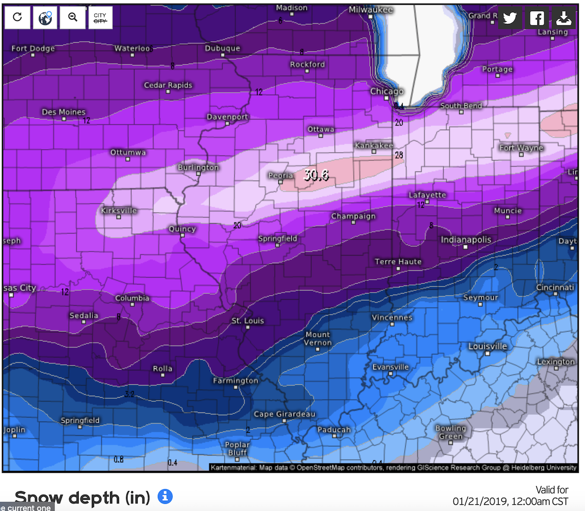
3-5" seems like a good call for IKK. Wouldn't take too much of a nudge north to realize slightly higher totals...wouldn't take too much of a nudge south to get slightly lower totals. All in all though, looks to be a decent event.
-
 [/IMG
[/IMG
Taken from here: http://www.greatlakes.salsite.com
-
2
-

Winter Storm? Jan 18-19th, 2019
in Lakes/Ohio Valley
Posted
Yeah, we are kinda screwed sitting in the middle. At least it shouldn’t be a shut out. Some snow is better than no snow.