

Amped
-
Posts
14,586 -
Joined
-
Last visited
Content Type
Profiles
Blogs
Forums
American Weather
Media Demo
Store
Gallery
Posts posted by Amped
-
-
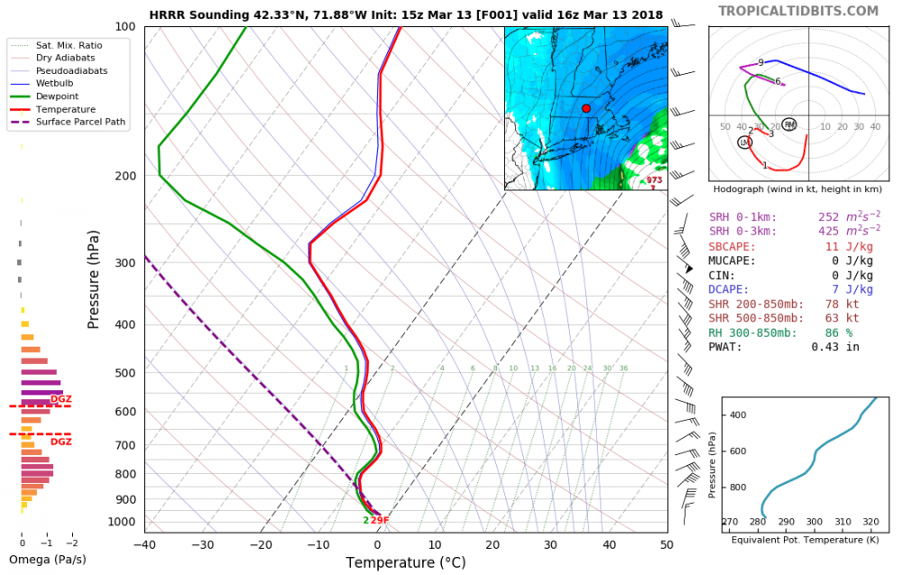
1 minute ago, CoastalWx said:
I would say fronto plots did have that. H7 forcing was just east and with sloped ascent, boom. Seems like it is slowly ticking east.
Yeah kind of an odd sounding there's lift above and below H7
-
So a deathband forms over ORH even if no model has one there.
-
GFS and ECMWF D9-10 showing a possible Philippines storm.
Storms don't often form below 10N, but when they do, there isn't much shear, and SSTS stay high year round in these areas.

-
 1
1
-
-
12 minutes ago, cmasty1978 said:
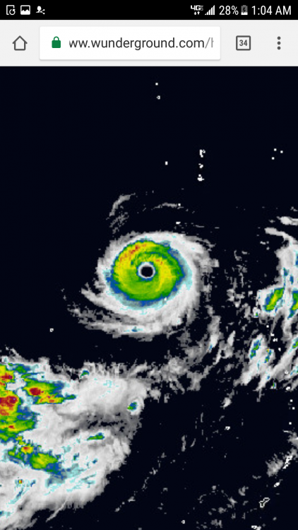
This is 100kts?
Sandy definitely looked worse. If they had satellite in 1938 it probably wouldn't have looked much better. Transitioning storms aren't going to look as good on satellite.
-
Probably down to a tame 100kts with a 10 foot storm surge over the worlds most populated area. No big deal.
-
Taken a big jog west of the forecast track the past few hours. Moving due north as far as I can tell.
-
You can see it's fighting off shear and dry and maintaining intensity. It will hit cooler SSTs after 00UTC but still above 26C until close to landfall. Also models show landfall between 15 and 18utc, this track looks a tad slow.
-
TransatedQuote
Typhoon 21 "eyes" enter by plane and direct observation successful
October 21 19:13
In order to investigate the very large and very strong typhoon 21, a research group centered on Nagoya University, for the first time as a Japanese researcher, entered the "eye" which is the center of the typhoon by airplane for the first time, We made observations. A huge cumulonimbus cloud developed around "eye" which is the center of the typhoon, it was observed that a violent wind was blowing in the periphery, and the expert who went for observation said, "In a typhoon-specific state that developed rapidly, In the future too, we need strict watchfulness against the raging rain and wind in a wide range. "
We conducted observations with research groups from typhoon experts such as Nagoya University and the University of the Ryukyus.
On the 21st, we took off Kagoshima Airport at noon, rose to an altitude of about 13 kilometers, and succeeded in entering the "eye" of the typhoon center from the west side of Typhoon No. 21 which developed into a very large and extremely powerful force did.
As I entered my eyes, the blue sky suddenly expanded, and the developed cumulonimbus called "wall cloud" appeared like a wall, and there was a place where the sea level could be seen near the center.
The research group swiveled around the center of the typhoon and dropped 21 pieces of observation equipment of about 30 cm in length called "drop sonde". Drop sonde records data such as wind speed, pressure, and humidity every minute every time while falling in clouds.
According to the observation on 21st, near the center of the typhoon, the pressure near the ground is around 925 hectopascals, the wind speed is 80 m/s at the point of 1 kilometer from the ground, 70 m/s near the ground, the violent wind is blowing That means that we could confirm.
According to the group, this is the first time for Japanese researchers to observe directly around the center of the typhoon by plane.
Professor Kazuhisa Tsuboki, a representative of the research group, said, "We were able to directly confirm the situation unique to the rapidly developing typhoon.In the vicinity of the wall clouds a violent wind was blowing, We need stern guard against fierce rain and wind. "
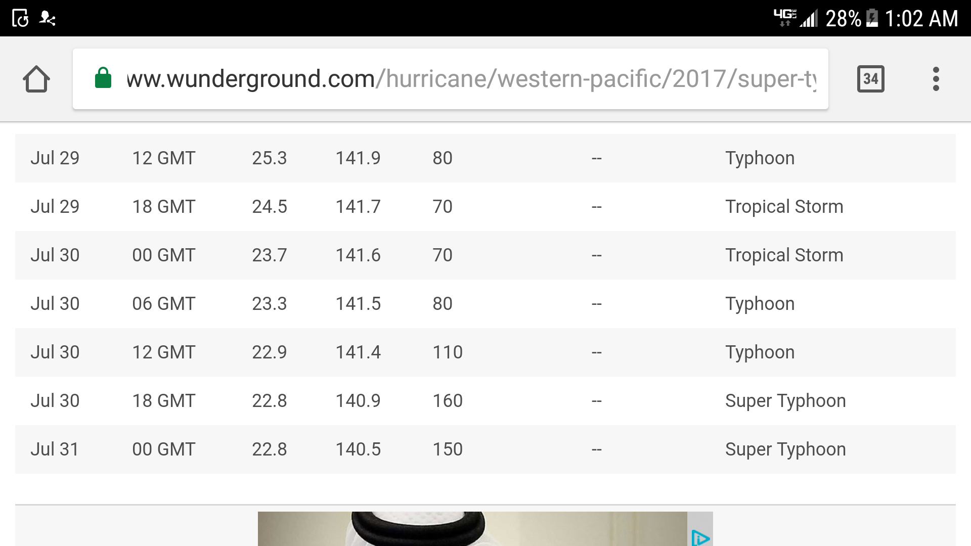
Related · Featured word70 m/s= 157mph . Also yesterdays 12z Euro 24hrs had 926mb. Todays 12z was initialized to 956mb. Euro track goes right up Tokyo bay, GFS is west of it.
-
2
-
-
11 minutes ago, Windspeed said:
I agree this has the potential to be a big hit for Japan. Though Lan won't hold this intensity, the fast movement will mitigate rapid weakening. This very well could be an upper end Cat 3 landfall for populated areas.

EPS mean is almost right over Tokyo. Going to get a huge surge up the bay with that track. This thing probably has a lot more integrated kinnetic energy than Isabel or Sandy.
-
This is going to get pretty ugly for Tokyo and a lot of Japan, hopefully they are well prepared.
-
1 hour ago, Amped said:
Not sure how -75.9, +19.5 is only a T6.3.
So it was a bit underdone here.
-
2
-
-
Not sure how -75.9, +19.5 is only a T6.3.
-
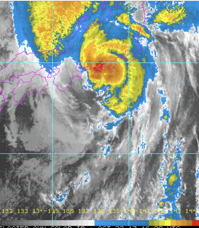
27 minutes ago, Windspeed said:
Not too shabby...

Looks like Lan finally got it's bandwidth upgraded.
-
2 hours ago, Windspeed said:2 hours ago, Amped said:I really don't know whats killing convection on the north side, there doesn't seem to be enough shear or dry air to account for that look. Maybe the storms just too damn big.
A 200mb right entrance region should start aiding it in about 24hrs, so pressure falls can resume despite the crappy structure.
You nailed it. That has been the issue. Lam developed as multiple surface circulations formed within a large surface trough. Over the past week, surface vorts have been competing within the large gyre. When you have that scenario, deep convection within one vort can suppress convection or create subsidence that affects parts of the overall core structure. However, it looks like a deep band is getting established and a dominate vortex will take over. The SSTs are plenty warm up to southern Japan. It may not reach Super Typhoon status, but I think it will definitly be a Cat 3/4 before the the typhoon nears Japan. Perhaps holds intensity enough to landfall as a 3.
Latest microwave pass says big but healthy. HWRF shows a decent 36hrs ahead.

Edit: Also you can see a second band on Himawari 8 rapidly making the core symmetric. Probably bombs away for real this time.
-
2
-
-
5 hours ago, cmasty1978 said:
this is a classic case of the euro's tendency to overdeepen storms in the WPAC at that latitude. it did the same thing with NORU earlier this season and LIONROCK last year. it's late october, nothing that strong and that tropical is hitting that far N into japan.
I really don't know whats killing convection on the north side, there doesn't seem to be enough shear or dry air to account for that look. Maybe the storms just too damn big.
A 200mb right entrance region should start aiding it in about 24hrs, so pressure falls can resume despite the crappy structure.
-
1
-
-
44 minutes ago, Chinook said:
Hi!
In the mid-range, this storm could be near Tokyo (see the JTWC forecast.) In the long range, this powerful storm now looks to recurve more east of Japan, rather than heading more north towards the mid-Bering Sea.

More convection on the NW side now. Should start to intensify rapidly. Euro would be a major hit for nearly all of Japan.
-
Microcane? Nah to make up for the missing storms we'll just have one thats as big as all of them combined.

-
Just when I thought this was the Irene of the WPAC, somehow it has made a comeback while skimming the coast. Very nice looking for a CAT1
-
12z Gfs and Euro went west and stronger. Going to be a good chase for josh. Possible sub 930 landfall.
-
8 hours ago, Rjay said:
Noru rapidly intensified before leveling off. Nice small annular storm that's taken an interesting track thus far.

Not supposed to stay small. Ecmwf and Gfs now make landfall next Monday/Tuesday.
-
12 hours ago, Bostonseminole said:
Will be in Tokyo next week, wonder if I get a nice visit from Noru towards the end of the week!
Certainly possible, Going to be nuts in the west pac, even if it doesn't make landfall.
-
1 hour ago, North Balti Zen said:
a south and east winter...lol.
Maybe up to 3" in the NE MD crush zone!!!
-
DCA doing better than Frederick. I have about 1.0-1.2
-
Nice pinhole eye trying to reform. Forecast has it a CAT 1 close to Manilla early on the 26th.


March 12/13/14 Blizzard/Winter Storm/WWA etc
in New England
Posted
Poor Tolland, they got fringed.