

Solak
-
Posts
6,434 -
Joined
-
Last visited
Content Type
Profiles
Blogs
Forums
American Weather
Media Demo
Store
Gallery
Posts posted by Solak
-
-
Who’s ready for an ice storm ? It’s showing up in the European model run today. Temps in the 20s and between 1.25 to 1.50 inches of freezing rain. This would be a week from tomorrow. I HIGHLY suggest you stay tuned and begin getting prepared. This COULD be a major ice event.


-
Well, everyone always says you need a good snowpack to sustain the cold air... Top GIF is the more recent.
-
 1
1
-
-
Waiting on photos!

-
0.56" on Sunday, 1.05" total for the weekend.
-
-
It's pretty wet out there for a "mainly after 4PM" forecast.
-
Just a trace sprinkle this morning, with nothing after they upped the chance to 60%.
Didn't have any of the breezy to windy conditions mentioned in the discussions, either.
A pleasant 64 out this evening at 8:23PM
-
Just a sprinkle over this way.
Looking at radar, I don't see this happening, though.
Rain likely, mainly between 1pm and 4pm.New precipitation amounts between a tenth and quarter of an inch possible. -
0.87" on Saturday.
-
48 and rain.
We've picked up 0.30" since the 12PM update added "New precipitation amounts of less than a tenth of an inch possible" to the afternoon grid.
-
Let's see how this weekend plays out.
-
0.28" yesterday.
-
Precip-wise, this was a pretty bad bust based on the forecast.
-
Only 0.18" yesterday, with no rain overnight.
Already have had gusts to 30mph this morning.
-
10 minutes ago, HKY_WX said:
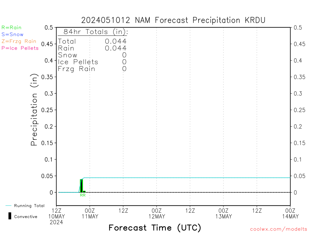
ANyone noticing the CAD/ice showing up on the NAM for tomorrow?
It's certainly there in the 12z run... bigtime. It is the NAM, though.
-
Going to be a rough weekend on the coast...
A powerful storm system will take shape off the Carolina Coast this weekend, bringing a variety of significant coastal impacts, including major coastal flooding, beach erosion, and strong winds.
https://www.weather.gov/media/mhx/LatestBriefing.pdf
-
1
-
-
-
It must be REALLY cold out there... What will they do when winter gets here?
Durham Public Schools canceled all after-school extracurricular activities Tuesday due to the cold weather.
-
 1
1
-
-
-
Watching the sunrise and waiting on the "mainly after 4AM" rain.
Then, the eyes will be squinting this evening, just in case...
I have some concerns that we`ll see a short
period of sufficiently high precip rates to switch us over to mostly
snow and sleet for a brief time, although likely no more than an
hour. While the ground should be warm enough to prevent accumulation
there (NC State Climate Office agnet stations confirm this), heavy
enough rates may produce a light coating on elevated surfaces.
Confidence in this scenario is not high enough to warrant any
mention of accumulation at this time. But this is certainly
something to be watched closely this morning.
-
Made it up to 70 this afternoon. Dropped down to 46 after dark, and has warmed back up to 57 at 10:00PM
-
RAH - For Thur/Fri
In terms of p-type Thursday night into
Friday...right now it looks like there's simply not enough cold air
involved with this system to warrant concern for anything other than
rain, esp given that the coldest air and northern stream is detached
and located well to our north while the aforementioned closed low is
moving across the Carolinas.  However and as always...we'll continue
to closely monitor trends in the guidance.
-
RAH --- model problems and forecasting for NC.
That Arctic front, analyzed at 20Z this afternoon from cntl WI swwd
to srn IA, then wnwwd across srn and wrn NE and cntl WY, will be
preceded by an increasingly closely-spaced but separate front
analyzed from nern OH swwd across cntl IN/IL/MO, sern KS, and the OK
and TX panhandles. A distinction between the two is critical for two
related reasons regarding how quickly cold, particularly Arctic air,
arrives in cntl NC: 1) the models tend to depict hypergradients
about such closely-spaced fronts as one and 2) how the models (fail
to accurately) resolve the Appalachian mountains yields a premature
Arctic air surge in the lee of the mountains. Consider the past two
early season Arctic frontal passages in cntl NC, for example, from
Halloween night and last Thu/Nov 7. In both cases the models rushed
the cold air east of the Appalachians prematurely relative to
reality.

These model failures are one of the chief reasons that a pattern
such as the one described above, with "cold air chasing the
moisture", fails to produce wintry precipitation in cntl NC.
Nevermind that it's still Nov. And it provides an opportunity for
failure of even the best of NWP ensemble systems that depict
accumulating snow in cntl NC, and for a human to add forecast skill
and value. With that in mind, a band of anafrontal rain, driven by
the right entrance region of a strong (125-150 kt) swly upr jet
streak from the cntl Appalachians to the Labrador Sea, behind the
lead front described above, will edge ewd across cntl NC late Mon
night and (particularly early) Tue - in a pattern very similar to
the band of anafrontal rain that occurred last Thu/Nov 7. The Arctic
boundary will then sweep sewd across cntl NC through early-mid
afternoon Tue, with following much below average temperatures,
including teens to low-mid 20s Wed morning, and highs only in the
upr 30s to low-mid 40s on Wed.
-
Already down to 32. Forecast calling for 31 for the low.


Mid to Long Term Discussion 2019
in Southeastern States
Posted
This is a pretty good read.