

BullCityWx
-
Posts
8,892 -
Joined
-
Last visited
Content Type
Profiles
Blogs
Forums
American Weather
Media Demo
Store
Gallery
Posts posted by BullCityWx
-
-
IF the RGEM is right about surface temps and we dont have to battle off a warm layer at the surface to start, then it's obviously off to the races with how significant this event could be.
-
The 12z RGEM is a whopping seven degrees colder at the surface than the NAM at 48.
-
 4
4
-
-
33 minutes ago, msuwx said:
GEFS went way up on snow totals in the NW half of NC on the 6z run, compared to 0z.
SREF went up last run too.
-
1
-
-
2 minutes ago, JoshM said:
Weenie Run

I don’t know I can remember a trail of snow accumulation from Brownsville to the Jersey Shore.
-
6 minutes ago, oconeexman said:
Gfs sticking to its guns..seems to steadily squash the energy. So far its by itself with the lack of moisture
I think this is probably where we talk about how god awful the GFS has been.
-
4 minutes ago, Met1985 said:
Congrats gulf coast on this run.
Man, imagine you live somewhere like Rockport, TX. It got wiped off the map, practically, and this run almost brings snow to the Texas shore.
-
1 minute ago, wncsnow said:
Looks like its getting going later, timing is very different
I'd agree with that.
-
I think it's going to be a good run through 57.
-
1
-
-
1 minute ago, shahroz98 said:
When was the last time flakes flew in early December ?
The last significant snow before, say, mid month here would have been back in 2002.
-
1
-
-
1 minute ago, griteater said:
GSP Discussion...
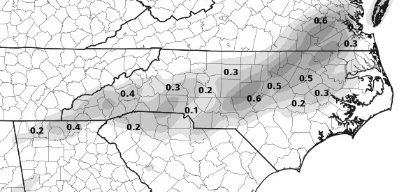
In response to encroaching positive tilt l/wv trough and developing upper jet dynamics, pcpn shield is progged to expand and develop back northward into the cwfa Thursday night. 05/12z SuperBlend and WPC guidance limits the increase to just chance pops thru the piedmont by daybreak Friday. Deeper forcing should increase into Friday with favorable upper jet positioning. Based on this, have increased precip chances to mid-chance with the best response slated to be atop the piedmont. Critical 85-70h thickness values should hover along the southeast fringe of the cwfa through Friday...a rough estimate of the rain/snow line for the bulk of the event. However, warm blyr temperatures makes it questionable on just how much snow would accumulate SE of I-85 where the liquid equiv QPF is the greatest. At this point, best combination of QPF and favorable temperatures looks to be North and NW of CLT where if any heavier bands are able to form would produce an inch of snow accumulation.
Might need to make the trip to McAdenville on Friday.
-
1
-
-
34 minutes ago, griteater said:
In cases like this where the only warm layer is right at the surface, this is what I've used/observed in the past...
If surface wet-bulb temperature is...
32: Snow
33-34: Snow or Rain/Snow Mix
35: Rain/Snow mix
36-37: Rain or Rain/Snow mix
I've been wondering how 11/19/2000 works out as an analog to this. I need to look into it.

-
-
5 minutes ago, Cold Rain said:
Lol no way
That's a concern, in my opinion, for RDU if they lose nucleation.
-
The sounding for the RDU airport at 84 is concerning because it isnt necessarily above freezing, you dont reach -15C until you get above the 500MB layer. It's hard to grow snowflakes like that.
-
We're safely isothermal in our sounding here but my biggest concern is the snow growth zone isnt saturated quite as deep as I'd like.
-
Just now, Lookout said:
an old one but good one....one of the first ones to offer point and click soundings. You are right though they are slower to update.
I cant complain about a free resource but its almost 10:30 and we're still on 75.
-
Just now, FallsLake said:
Even with the NAM look, it would be a slush fest. Still I would consider this a win:
total accumulation for hour 84:
I think it probably snows most of the day on Friday but whatever moisture is left from Friday Night into Saturday has a good shot at sticking.
-
7 minutes ago, snowlover91 said:
I use this site for soundings. They are a little slow to update but the soundings are solid. Just click on the map for the sounding and then adjust the position of it, it even gives a text output option which is very useful.
Thanks! I usually use plymouth because of the immediacy but again, they only go out to 60.
-
Just now, snowlover91 said:
Soundings are your best friend
") Nam is great for sniffing out warm noses but can be overamped at extended ranges of 60+ hours so I wouldn't put too much stock in this solution for now... but it is useful for seeing where a warm nose might set up.
Nam is great for sniffing out warm noses but can be overamped at extended ranges of 60+ hours so I wouldn't put too much stock in this solution for now... but it is useful for seeing where a warm nose might set up.
My usual site that I get soundings from, it wouldnt even be in range until tomorrow evening.
-
Just now, Cold Rain said:
Good deal. Thanks!
There is definitely some sort of warm nose, I just dont know how thick it is.
-
RDU does get to 0.7 at 850. 925's are below freezing though so I am not sure how deep that above freezing level would be.
-
1
-
-
Just now, Cold Rain said:
Yeah, that looks good, assuming there's no warm nose aloft.
925s look okay.
-
2
-
-
Just now, FallsLake said:
I think it would flip back to snow with the heaver rates. Dew points continue to show a colder look (...storm creating it's own cold):

There's also some decent lift showing up over the Pee Dee of SC and Coastal Plain of NC.
-
4 minutes ago, griteater said:
CMC looks a little quicker with the storm this run...has some light snow in north GA to upstate to parts of central, then western NC....not a lot of precip thrown back west into the cold air
Almost like a middle ground between the GFS and NAM.


The December to Remember 7th-8th blue turd winter threat thread.
in Southeastern States
Posted
Yeah, GSP has noted that several times.