

BullCityWx
-
Posts
8,892 -
Joined
-
Last visited
Content Type
Profiles
Blogs
Forums
American Weather
Media Demo
Store
Gallery
Posts posted by BullCityWx
-
-
4 minutes ago, SnowGoose69 said:
I know last year that ATL got their first ever severe freezing rain event without a wedge so anything can happen
I can name numerous similar events here to what’s depicted tomorrow. Now, it does mean all three slots in the slot machine line up but it can happen.
-
6 minutes ago, SN_Lover said:
Let me tell you the tale of a snowstorm with no parent high. It was the eve of a storm system, all the weenies gleaming at the models sudden "trend". Weenies wake up and all is cold, then when rain arrives all is toasty. Weenies disappoint and vent on Americanwx.
And yet they still knew how to use the banter thread
-
 2
2
-
-
RGEM has a 6” stripe from basically lake norman through the triad and up into lower VA.
-
Just now, Wow said:
18z GEFS getting serious.
")

Beginning to wonder if some of the modeling is catching on to the boundary layer not being as warm as expected?
-
1
-
-
2 minutes ago, JoshM said:
I think we're in good shape atm, but that 540 line is scaring me.
That mean just surprised me. It went up 3”.
-
1 minute ago, DixieBlizzard said:
Hey, @WXinCanton, check this out my friend. I have been in Ellijay for a year now. This looks good for our areas!
Good luck to y’all.
-
1
-
-
I’ve been busy this afternoon so I’m catching up on some 12z and later runs. EPS jumped me up to a 4” mean in Davidson. Huh.
-
1
-
-
Not only is there no warm nose at all on the RAP, we’re safely isothermal in my back yard.
-
1
-
-
There is some strong lift showing up which could indicate banding which means some places could really score and some places get rain, just because of rates.
-
1 minute ago, rdwhynot said:
Wow, this looks nice on the Meteogram Generator for KBHM, but who knows if it will materialize?
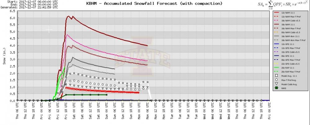
Most of those use ratios that won’t be possible this week.
-
Dont just throw out the RAP with the ptypes. I cant tell you how many times I've seen that model sniff out a warm layer when every other model is good to go. It's showing some very strong lift along 85 from ATL-CLT. We'll see.
-
1
-
-
1 minute ago, tramadoc said:
Is the CMC running late? I don't see any usual sites with it up.
It stopped running around hour 13.
-
30 minutes ago, Wow said:
The 0.75" QPF line runs along I-85 this run. Quite a jump. Just how well the low level cold air works in will be the big question.
Looking at soundings, the warm layer that is on the NAM isnt on the GFS. We're fighting the surface on the GFS.
-
12 minutes ago, DopplerWx said:
brutal warm nose on the hi-res nam. upstate sc looks like snow initially with the heavier rates but quickly goes back to rain. clt east looks like all rain.
It looks like, locally speaking, the rain/snow line runs roughly from Lincolnton to Mooresville.
-
The german model, which did really well last year, has this event as mostly snow.
-
1
-
-
27 minutes ago, griteater said:
Here are the Charlotte surface observations from the Nov 2000 storm. It probably won't be this cold, but similar setup relying on precip to cool the lowest warm layer in the atmosphere


That has been one of my favorite analogs this week. Hell, we even played the Vikings that weekend too.
-
1
-
-
RGEM looks maybe a bit lighter this run. Not much difference.
-
A few other EPS means:
Davidson: 2.6"
Lexington: 3"
Asheboro: 3.7"
Raleigh: 2.5"
CLT: 2.8"
-
3
-
-
The mean on the EPS doubled for me this run to get me to 2.6”
-
1
-
-
1 minute ago, griteater said:
If you mean snow with a lakes low, no high to the north, and no cold air damming, Jan 1987 is one


If I'm remembering correctly, that was forecasted as just a mix.
-
1
-
-
6 minutes ago, NC_hailstorm said:
Ukie has a 1001 low right on Myrtle Beach at 72.Just from experience,that's a classic track for the I-85 corrider in western NC usually.
We'll see.
That is the wheelhouse for you, me, grit and wow.
-
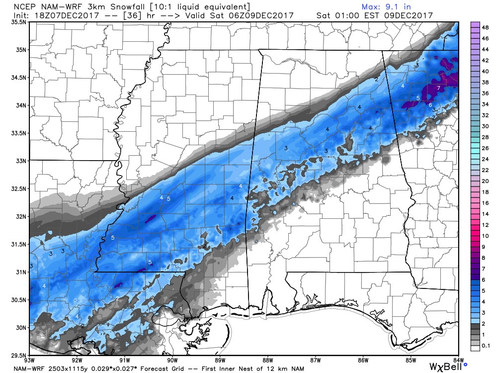
Can anyone vouch for the accuracy of this tool on pivotal?

-
3 minutes ago, TellicoWx said:
I can loan you guys some of the cold air in exchange for some moisture. Hard watching moisture come up out of the gulf and be right on the edge here along the mountains in east TN lol.
Imagine you live in Birmingham and you see Montgomery get the snow the models are showing while Birmingham gets nothing.
-
1 minute ago, packbacker said:
ColdRain and I can smell the snow on the CMC...we got that going for us. And this isn't even close to being done yet...

Pack, it snows in MBY for 30 hours. Kinda blows my mind.
-
1
-
The December to Remember 7th-8th blue turd winter threat thread.
in Southeastern States
Posted
FWIW, the NAM initialized with a DP that was two degrees too high. Every degree matters tonight.