Ace
-
Posts
198 -
Joined
-
Last visited
Content Type
Profiles
Blogs
Forums
American Weather
Media Demo
Store
Gallery
Everything posted by Ace
-
Great job!
-
Allagash white is a top tier beer
-
July 2020 General Discussions & Observations Thread
Ace replied to Rtd208's topic in New York City Metro
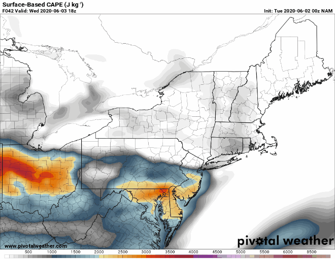
Upton is very bullish. Although the focus of the long term remains Isaias, there is the potential for a round of significant severe weather on Sunday. A warm front is progged to be lifting thru the area on Sun. The 12Z NAM builds SBCAPE to over 3000 J/kg. Sufficient shear puts the BRN firmly in the supercell range. In addition, A high EHI embedded in this regime will add a tor threat. It is still too far out to have high confidence in the details and timing, but the data suggests the ingredients are potentially there for a svr wx outbreak. Future forecasts and SPC outlooks will refine this threat over the weekend. Pops were limited to 50 percent based on the uncertainty, although the NBM suggests categorical across the interior. -
July 2020 General Discussions & Observations Thread
Ace replied to Rtd208's topic in New York City Metro
All eyes on Isaias, but Sunday could be a big time severe weather day. Probably more so for upstate NY/PA, but we'll see. -
July 2020 General Discussions & Observations Thread
Ace replied to Rtd208's topic in New York City Metro
Going to be a disgusting day with high dew points (mid to upper 70's!) and high PWAT's. Instability values will be impressive and we may benefit from good timing (afternoon start time). Hopefully we don't get any morning activity to screw us over. -
Great discussion. The area you highlighted (N PA/extreme S NY/perhaps Northern NJ) certainly seems to have the best chance at the moment as it appears to be at the intersection of good shear and decent instability. Kinda sucks lapse rates aren't impressive. The 12z NAM shifts the morning activity north of us (but we still get some debris for a few hours) and keeps us dry in the afternoon too. Parameters still look decent though. In addition, some of the other CAM's get some good activity going in our area in the afternoon. We'll see what happens, but if we are able to dodge most of the morning debris, I certainly wouldn't mind an early band coming through (early afternoon)
-
June 2020 General Discussions & Observations Thread
Ace replied to Rtd208's topic in New York City Metro
Heads up NYC metro. We may have some storms to deal tonight. Mesoscale Discussion 0802 NWS Storm Prediction Center Norman OK 0558 PM CDT Wed Jun 03 2020 Areas affected...eastern PA...northern NJ...and southern NY Concerning...Severe potential...Watch unlikely Valid 032258Z - 040030Z Probability of Watch Issuance...20 percent SUMMARY...An organized cluster of thunderstorms across eastern PA is likely to pose at least a marginal threat for strong winds this evening. Limited buoyancy in the wake of previous convection will likely support only limited coverage of storms, and a watch is not anticipated. DISCUSSION...A cluster of thunderstorms over eastern PA has increased in convective intensity over the last hour. These storms are ongoing ahead of a shortwave trough over Quebec and the eastern US. Warm surface temperatures in the upper 70s and and low 80s with dewpoints in the mid 60s F ahead of these storms are supporting MLCAPE of 500-1000 J/kg. A 50-60 kt mid-level jet ahead of the shortwave trough is supportive of favorable deep-layer shear profiles with 40-50 kt of effective shear. The combination of instability and shear should support continued organization of the ongoing storm cluster for a few more hours across portions of New York and New Jersey. Damaging winds will be the primary threat given the linear nature of the ongoing storms and extended but straight line hodographs. Limited spatial coverage and the lack of greater instability due to previous convection will likely limit the threat. No watch is planned at this time.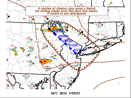
-
June 2020 General Discussions & Observations Thread
Ace replied to Rtd208's topic in New York City Metro
The SPC's forecast last night has the main threat for tomorrow to our Southeast (SE PA, S NJ). However, the NAM over the last 2 runs has trended further north with its instability values coinciding with the passing vort being further north. I would sell these high instability numbers that its showing for the 12z run, but could be an active day in the area.