

Allsnow
-
Posts
26,403 -
Joined
-
Last visited
Content Type
Profiles
Blogs
Forums
American Weather
Media Demo
Store
Gallery
Posts posted by Allsnow
-
-
1 hour ago, CoastalWx said:
Over 1.2” SW CT. Seymour ftw.
-
 1
1
-
-
Just now, Allsnow said:
-
Why the concern about this busting?
-
.30 already and radar looks good for at least a inch
-
1
-
-
1 hour ago, snowman19 said:
So are we are going to see benchmark storms with 50 degrees and rain?
-
 2
2
-
-
Msp with 9.5
-
 1
1
-
-
Msp 9.5 total!
-
-
27 minutes ago, snowman19 said:
After what the abysmal GFS just pulled for this weekend, it could tell me the sky is blue and I wouldn’t believe it
-
12z gfs looks ugly for next week now
-
58 minutes ago, A-L-E-K said:
bullseyed that narrow weenie band, very nice score
The euro was $ for this event
-
2
-
-
21 minutes ago, CoastalWx said:
Not sure how it plays out, but it certainly will get more active. Like Ray said, you knew that would happen.
-nao coming to end the sandbar fun
-
-
1
-
1
-
-
MSP might end up close to 10
-
3
-
-
Msp getting crushed
-
6 minutes ago, LibertyBell said:
looks very warm for the 12th at least.
EPS doesn’t break 60 now
-
-
3 minutes ago, Allsnow said:
EPS cooled off for next week haha
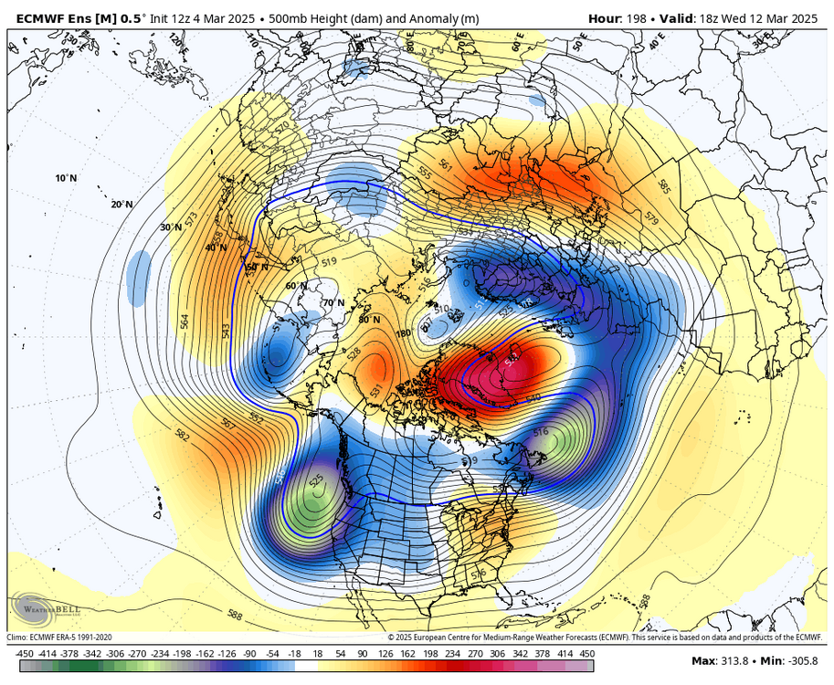
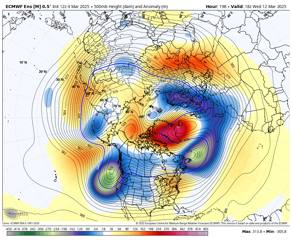
Negative nao trending stronger for next week
-
EPS cooled off for next week haha
-
1
-
-
1 minute ago, Stormlover74 said:
Omaha finally getting theirs. Not a lot of snow but it's 58 right now so this will be kinda crazy tonight
...BLIZZARD WARNING REMAINS IN EFFECT FROM 8 PM THIS EVENING TO 3 AM CST WEDNESDAY...
* WHAT...Blizzard conditions expected. Total snow accumulations of one to three inches expected, as much as five inches possible. Winds gusting as high as 65 mph. Flash freeze expected.
Msp as well
-
2
-
-
4 minutes ago, EastonSN+ said:
Also the NE forum had a great point, non-benchmark tracks are approx 85% of our normal storm track. So even taking the fast pac out it's hard to get a heavy snow event here.
Yeah, 85% of the other storm tracks happen more…
Amazing stuff haha
-
 1
1
-
 1
1
-
-
7 minutes ago, CoastalWx said:
Follow it? They’ve all been sober except for the GFS.
If the euro AI doesn’t have it, we don’t do it
-
1
-
-
1 hour ago, bluewave said:
Good to see the GFS joining the Euro on 70° potential next week for the warm spots as everyone is ready for spring at this point.

The -nao is going to screw us after one day near 70
-
1
-
-
No reason to use any other model other then the AI

March DISCO/OBS: Please End It
in New England
Posted
No stein