

CNY_WX
-
Posts
2,717 -
Joined
-
Last visited
Content Type
Profiles
Blogs
Forums
American Weather
Media Demo
Store
Gallery
Posts posted by CNY_WX
-
-
7 minutes ago, sferic said:
Think positive ! I'll gladly take 7 inches but it more than doubled on the probabilistic from 1am to 7am; but we'll see
I’ve been burned by too many lake effect snow events which has made me a pessimist. I hope I’m wrong and we get a foot plus.
-
 3
3
-
-
4 minutes ago, sferic said:
Wow, looking at the probalistice forecase for N Onondaga, wow; 14",? I'll gladly take it
Can actual these exceed these amounts in my part? We'll see, but geared up with food, salt and will be up for next 24 hours which i guess is par for the course
I’d gladly take the 16 inches. Am I counting on it - no. I expect the heaviest snow to be just north of me and we’ll be lucky to get a couple of inches with the Arctic fropa.
-
1
-
 1
1
-
-
...WINTER WEATHER ADVISORY IN EFFECT FROM 6 AM TO 7 PM EST
SUNDAY...
...LAKE EFFECT SNOW WARNING IN EFFECT FROM 7 PM SUNDAY TO 1 AM
EST TUESDAY...

* WHAT...For the Lake Effect Snow Warning, heavy lake effect snow
  expected. Total snow accumulations of around 2 feet in the most
  persistent lake snows. Winds gusting as high as 35 mph will
  produce blowing and drifting snow. For the Winter Weather
  Advisory, mixed precipitation expected. Total snow accumulations
  of 1 to 3 inches and ice accumulations of around one tenth of
  an inch.

* WHERE...Oswego and Lewis counties. Heaviest lake effect snow
  will focus across northern Oswego and far southwest Lewis
  counties.

* WHEN...For the Lake Effect Snow Warning, from 7 PM Sunday to 1
  AM EST Tuesday. For the Winter Weather Advisory, from 6 AM to
  7 PM EST Sunday.
-
 1
1
-
-
1 minute ago, sferic said:
Just got a delivery ( 3 large desks for my computer work area) from Fed Ex
Young lady driving said she's from Central Square where there's a foot of snow OTG, wow got to take a drive up there
I believe it since that’s where the band of heavy snow set up for much of the afternoon. I’m 5 miles south and was right on the southern edge, in and out of light snow and sunshine. When the band did move south later in the afternoon it snowed heavily here for over an hour. That’s when I got the majority of my 5.3 inches.
-
2
-
-
1 hour ago, wolfie09 said:
I think they fell just below zero but not enough to make it a -1 lol
The official low between hourly readings at Syracuse was -2, the coldest in 2 years. Watertown got down to-26, the coldest reading in the nation.
-
2
-
2
-
-
I posted this in the lake effect thread, too.
My measurements from this morning: 5.3 inches of snow, 0.16 inch of liquid, ratio = 33:1. Also, the low here this morning was -7F, the lowest so far this season.
-
3
-
-
My measurements from this morning: 5.3 inches of snow, 0.16 inch of liquid, ratio = 33:1. Also, the low here this morning was -7F, the lowest so far this season.
-
1
-
-
3 minutes ago, Ottawa Blizzard said:
I well remember the winter of 1994! Record cold across eastern North America. It was the coldest January in Toronto since 1920, and I believe Ottawa's coldest of the 20th century.
You’re right. It was a couple of weeks after this storm that some of the coldest weather hit the northeast US and adjacent Canada. I was living in an older house in Little Falls in the Mohawk Valley and I stayed up one night listening to the furnace run. I believe it ran for 50 minutes and only shut down for 10 minutes in an hour.
-

I’ve been meaning to post this. It’s the front page of the Syracuse Post Standard from January 5, 1994. The previous day a coastal storm dropped 17.5 inches of snow on Syracuse. Although this might not seem like a lot by lake effect standards, 9.5 inches of this fell between noon and 2 PM causing chaos on the roads as businesses dismissed their employees early and cars became stuck as plows could not make their way through the parking lots major highways had become. This resulted in new dismissal plans for future snowstorms. I also wanted to illustrate that Syracuse can get blasted by nor’easters. This storm was triggered by a negatively tilted H500 trough which transported waves of snow off the Atlantic Ocean into central New York. It seems that during the 90s we had a lot of these types of storms. Hopefully we will see storms like this in the future.
-
1
-
4
-
-
24 minutes ago, Blue Moon said:
What do you figure the ratios are right now? It's been in the 20s in Oswego today, and it's currently 21. If 15:1 is reasonable then it's safe to say our QPF for the past 24 hours is around 0.07 in.
I’ll let you know the LE and ratio in the morning when I take my measurement.
-
1
-
-
9 minutes ago, Syrmax said:
It's over me also. Easily 1"/hr stuff. Probably more.
It does appear to be slowly sinking south so we’ll see how long we can stay in it.
-
2
-
-
5 minutes ago, wolfie09 said:
We have had steady snow the last couple hours or so with the occasional heavier burst..Wind has been fierce lol

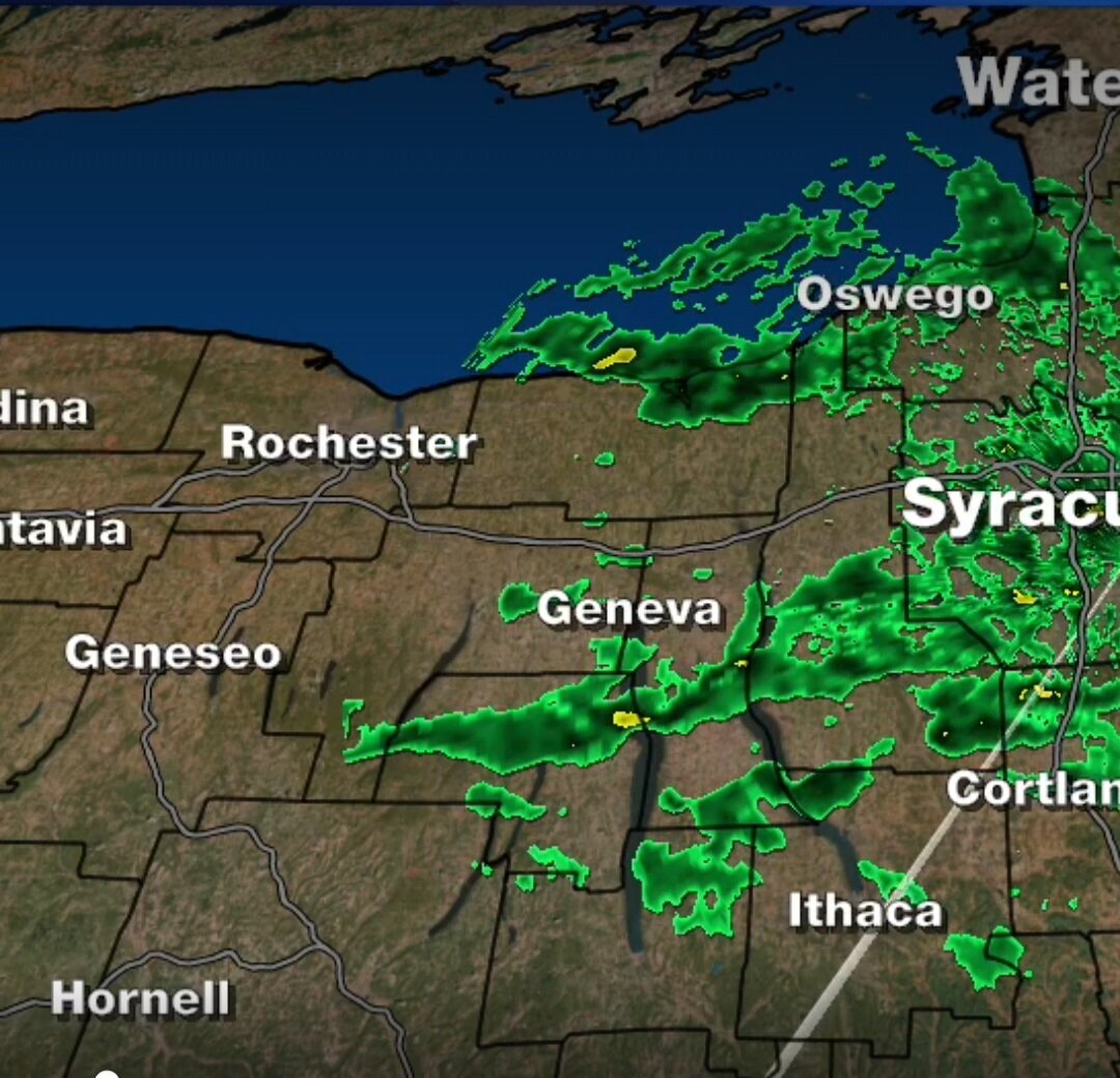
That dark green band at the southern edge of the returns is right over me.
-
2
-
-
Channel 9 is calling for 1-3 inches this event in the most persistent bands. I’ll have the 3 inches in an hour if this keeps up.
Edit: Should read 1-3 this evening.
-
3
-
-
Temperature has dropped to 18.
-
6 minutes ago, Syrmax said:
SN+ has slipped back in here. With wind.
Same here.
-
The heaviest snow has set up literally 5 miles north of me. I’m on the southern edge of the band so I’m going between light snow and periods where the sun is shining.
-
1
-
-
It’s snowing heavily here again. That band off the lake made it here and I’m in the middle of a heavy squall now. Unfortunately for you, Sferic, there’s a pretty sharp cut off to the south.
-
A new band has formed over the lake. Hopefully it’s trajectory will send it towards me.

-
4 minutes ago, vortmax said:
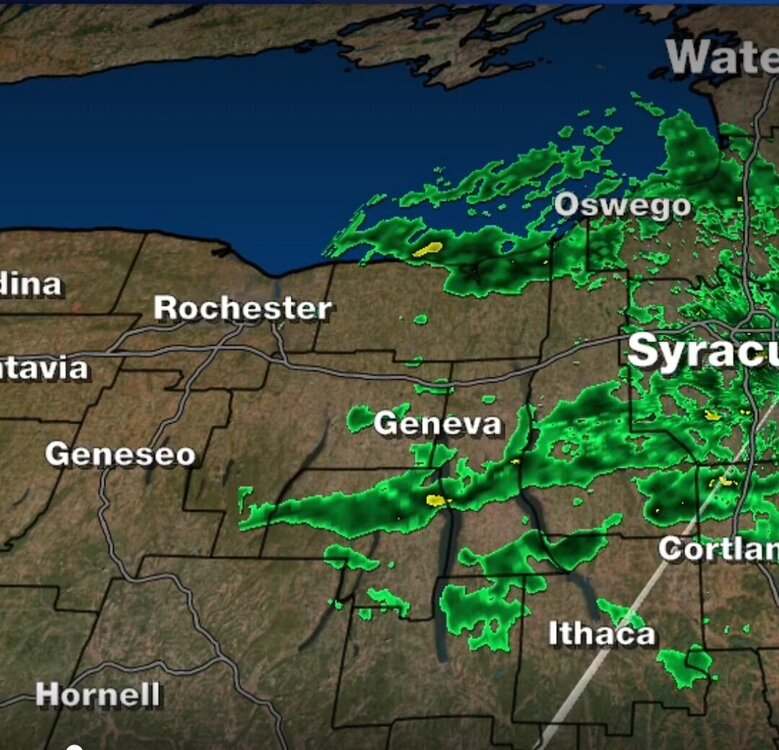 Setting up just east of me over Sodus. Sunny here. Ugh!
Hopefully that is heading towards me.
-
1
-
-
Only 1.5 inches here since 8:30 this morning. Picked up half an inch overnight so about 2 inches total.
-

Finally snowing heavily here.
-
3
-
-
Snow’s picked up here but still light.
-
15 minutes ago, TugHillMatt said:
I don't know. It's looking pretty good for our weenie zone of Northern Onondaga county.

Looks like it’s made it as far as you. I’m still in that snow hole and waiting for the squalls to fall apart before they make it here.-
 1
1
-
-
13 minutes ago, TugHillMatt said:
That area near Fair Haven is giving this a little push.

I’m waiting for it to make a right hand turn.


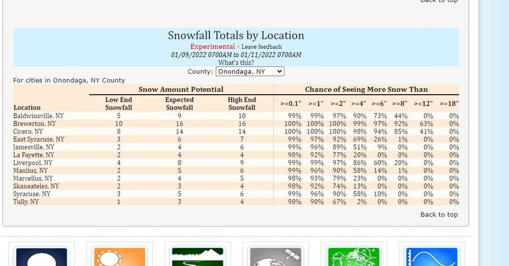
Upstate/Eastern New York- Jan 9-11 Lake Effect Snow Event
in Upstate New York/Pennsylvania
Posted
So what’s the over/under on how much we’ll get by Tuesday morning in northern Onondaga? I’m thinking 6 inches