

96blizz
-
Posts
2,530 -
Joined
-
Last visited
Content Type
Profiles
Blogs
Forums
American Weather
Media Demo
Store
Gallery
Everything posted by 96blizz
-
Feb 2-4th Snowstorm- Observation Thread
96blizz replied to BuffaloWeather's topic in Upstate New York/Pennsylvania
The only redeeming quality of us ramming that point home was they were ALL at the same time - meaning we are really ridiclous. -
Feb 2-4th Snowstorm- Observation Thread
96blizz replied to BuffaloWeather's topic in Upstate New York/Pennsylvania
For sure that razor thin line will have maximas - but not far to the North and West of that - ratios will be a bit better - likely making things a bit more uniform than it looks. -
Feb 2-4th Snowstorm- Observation Thread
96blizz replied to BuffaloWeather's topic in Upstate New York/Pennsylvania
Is...is...is...is this a positive post?!?!?!?!? -
Feb 2-4th Snowstorm- Observation Thread
96blizz replied to BuffaloWeather's topic in Upstate New York/Pennsylvania
Starting to pick up in Skan now. Getting closer to game time. -
Feb 2-4th Snowstorm- Observation Thread
96blizz replied to BuffaloWeather's topic in Upstate New York/Pennsylvania
What's with the 10:1 nonsense? Kuchera that dawg up! -
Feb 2-4th Snowstorm- Observation Thread
96blizz replied to BuffaloWeather's topic in Upstate New York/Pennsylvania
Peter Hall is such a weenie. Great guy - love it!! -
Feb 2-4th Snowstorm- Observation Thread
96blizz replied to BuffaloWeather's topic in Upstate New York/Pennsylvania
Syracuse weenies unite! -
Feb 2-4th Snowstorm- Observation Thread
96blizz replied to BuffaloWeather's topic in Upstate New York/Pennsylvania
This is something you don’t see often! -
Feb 2-4th Snowstorm- Observation Thread
96blizz replied to BuffaloWeather's topic in Upstate New York/Pennsylvania
I Love Canada!!!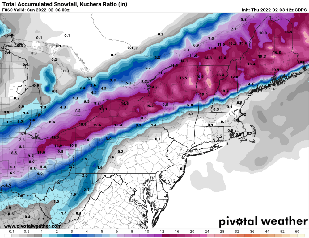
-
Feb 2-4th Snowstorm- Observation Thread
96blizz replied to BuffaloWeather's topic in Upstate New York/Pennsylvania
Makes sense if you look at the finger lakes. Elevation drop from South to North is dramatic. Will take some good rates to overcome that. It’s coming. -
Feb 2-4th Snowstorm- Observation Thread
96blizz replied to BuffaloWeather's topic in Upstate New York/Pennsylvania
Lol @TugHillMatt -
Feb 2-4th Snowstorm- Observation Thread
96blizz replied to BuffaloWeather's topic in Upstate New York/Pennsylvania
Exactly this. I come from NJ and feel the same. We just shrug our shoulders and maybe grab some extra junk food for fun. That and there a LOT less people. Thank God. -
Feb 2-4th Snowstorm- Observation Thread
96blizz replied to BuffaloWeather's topic in Upstate New York/Pennsylvania
Depending on your drop down you won't see light lake enhanced snows. -
Feb 2-4th Snowstorm- Observation Thread
96blizz replied to BuffaloWeather's topic in Upstate New York/Pennsylvania
One more WEENIE MAP! Hey yo Vermont! -
Feb 2-4th Snowstorm- Observation Thread
96blizz replied to BuffaloWeather's topic in Upstate New York/Pennsylvania
Latest GFS snows all day tomorrow into the night. -
Feb 2-4th Snowstorm- Observation Thread
96blizz replied to BuffaloWeather's topic in Upstate New York/Pennsylvania
No model has much at all here till later today. Here's the most recent HRRR for 4 hours from start. -
Feb 2-4th Snowstorm- Observation Thread
96blizz replied to BuffaloWeather's topic in Upstate New York/Pennsylvania
Here comes the lull for many of us. This is where the layperson starts to laugh at Meteorologists and then gets stuck this evening. -
Feb 2-4th Snowstorm- Observation Thread
96blizz replied to BuffaloWeather's topic in Upstate New York/Pennsylvania
Lovely. LET’S GO!!!!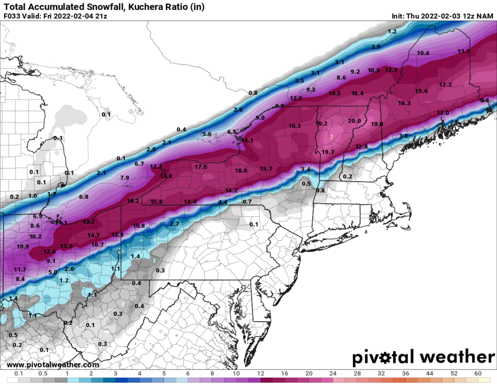
-
Feb 2-4th Snowstorm- Observation Thread
96blizz replied to BuffaloWeather's topic in Upstate New York/Pennsylvania
The NAM will probably spit 15” for some at 10:1. -
Feb 2-4th Snowstorm- Observation Thread
96blizz replied to BuffaloWeather's topic in Upstate New York/Pennsylvania
GFS struggled the most for S and E of here. Wasn’t all bad here - but got a lot of hopes up closer to the major cities. -
Feb 2-4th Snowstorm- Observation Thread
96blizz replied to BuffaloWeather's topic in Upstate New York/Pennsylvania
This NAM run is so awesome. I live for this. -
Feb 2-4th Snowstorm- Observation Thread
96blizz replied to BuffaloWeather's topic in Upstate New York/Pennsylvania
The schools here could be in a bit of a quagmire. They just left but it could get hairy later… -
Feb 2-4th Snowstorm- Observation Thread
96blizz replied to BuffaloWeather's topic in Upstate New York/Pennsylvania
Remarkably the GGEM and NAM IMO. They never bit on anything SE and were consistent with the big time second wave. -
Feb 2-4th Snowstorm- Observation Thread
96blizz replied to BuffaloWeather's topic in Upstate New York/Pennsylvania
I know it’s too late for models but the NAM looks exquisite. I’m so pumped. -
Feb 2-4th Snowstorm- Observation Thread
96blizz replied to BuffaloWeather's topic in Upstate New York/Pennsylvania
Starting to get better flakes here. The NAM also is looking a bit more robust with the first wave.


