

Cfa
-
Posts
4,400 -
Joined
-
Last visited
Content Type
Profiles
Blogs
Forums
American Weather
Media Demo
Store
Gallery
Posts posted by Cfa
-
-
High of 92 today, 89.4 yesterday, the literal worst almost-90 in existence. I have to tally up my 90’s.
-
 1
1
-
-
Radar is definitely more impressive than reality, rate is 0.12” per hour at my PWS. There’s a nice breeze with inconsistent, but loud, thunder though, almost sounds like an elevated subway overhead at times.
-
I don’t rely on weather app forecasts but I’ve never seen triple digits advertised this far in advance.
-
1
-
-
Pouring with sunshine in Sayville.
-
1
-
-
Non-accumulating raindrops, line completely DOA here.
-
0.00” here. 79/73 with some sun now.
-
Pouring in East Northport.
-
1
-
-
This batch is barely missing me to the east. It’s kind of a good thing as they largely missed out on the earlier batch.
-
1
-
-
79/79 with some sunshine poking through. 5.05” total so far, first calendar day to clear 5” in my PWS’s 5 year history (6th summer).
-
A few tenths of an inch under 5.00” here, which isn’t far off from my May, June, and July (before today) totals put together. Crazy how dry it’s been.
Also likely the wettest day on record for my PWS.
-
1
-
-
Just cleared 4” here.
-
I know it won’t be as bad but this is reminding me of the August 2014 event that dropped 13” at ISP.
Everyone’s phones just started buzzing for the Flash Flood Warning.
-
1
-
-
1.17” with nearly 2” per hour rates.
Edit: 1.47” with 3” per hour rates just 3 minutes later.
Edit again: 1.90” with 5” per hour rates. Possibly a record for my PWS.
-
1
-
-
Tornado Watch just issued.
URGENT - IMMEDIATE BROADCAST REQUESTED
Tornado Watch Number 497
NWS Storm Prediction Center Norman OK
820 AM EDT Sun Jul 16 2023The NWS Storm Prediction Center has issued a
* Tornado Watch for portions of
Connecticut
Massachusetts
Southern Maine
New Hampshire
Southern New York
Rhode Island
Coastal Waters* Effective this Sunday morning and afternoon from 820 AM until
300 PM EDT.* Primary threats include...
A couple tornadoes possible
Scattered damaging wind gusts to 60 mph possibleSUMMARY...A very moist environment and relatively strong
low/mid-level atmospheric winds will support the potential for
rotating storms capable of tornadoes and localized wind damage this
morning into afternoon.The tornado watch area is approximately along and 55 statute miles
east and west of a line from 10 miles east southeast of Islip NY to
30 miles north northeast of Laconia NH. For a complete depiction of
the watch see the associated watch outline update (WOUS64 KWNS
WOU7).PRECAUTIONARY/PREPAREDNESS ACTIONS...
REMEMBER...A Tornado Watch means conditions are favorable for
tornadoes and severe thunderstorms in and close to the watch
area. Persons in these areas should be on the lookout for
threatening weather conditions and listen for later statements
and possible warnings.&&
AVIATION...Tornadoes and a few severe thunderstorms with hail
surface and aloft to 0.5 inches. Extreme turbulence and surface wind
gusts to 50 knots. A few cumulonimbi with maximum tops to 500. Mean
storm motion vector 22030....Guyer
-
Just started pouring here, already up to .20”, an inch+ with this batch should be possible as it’s aimed directly at me.
78 degree low getting destroyed though.
-
79/78. High was 88, low was 74. DP hit 80.
Rain missed me to the northeast earlier.
-
18 minutes ago, Rmine1 said:
Talk about splitting the uprights! Pouring 2 miles to my west and southeast. Nothing here
That little split was heading this way and it filled in at the last minute.
-
Sky looks 8:30 PM in Bohemia.
-
0.29”, heaviest downpour in ages, wish it lasted longer.
Inside the newly issued Special Weather Statement box but I doubt I’ll see anything more, everything looks just to the north.
-
Finally scoring, heaviest rain in months here. CG strike about 30 feet away too, instant thunder, phone notification 10 seconds later.
-
1
-
-
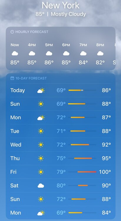
Is the heat wave criteria of three consecutive days of 90 local to our region? Or is it a general rule? I’m on my second heat wave in a week (and this year), 90’s barely even stand out anymore they almost feel average. Maybe 4 or 5 consecutive days or a threshold higher than 90 would be more fitting.
88 now, down from 90. Clouding up in Garden City, PWS still showing full sun in Suffolk.
-
High of 96 here, highest of the year, currently 87.
-
94, humidity slowly creeping back up.
-
92 here too.
-
1
-
July 2023
in New York City Metro
Posted
91/79/110 on my Kestrel in Huntington.
87/80/102 at my PWS. High of 92 so far there.