

cny rider
-
Posts
964 -
Joined
-
Last visited
Content Type
Profiles
Blogs
Forums
American Weather
Media Demo
Store
Gallery
Posts posted by cny rider
-
-
33 minutes ago, Typhoon Tip said:
For the hawks nests maybe.
I don't diminish the cold profile at this late in the year, but that's the eastern region of the Tug Hill, which has an elevation around 2,000 ... than again S Greens and up there near the Presidential Range in NH.
Those are the Adirondack high peaks. Tug Hill is west of there, off the eastern end of Lake Ontario.
-
 4
4
-
-
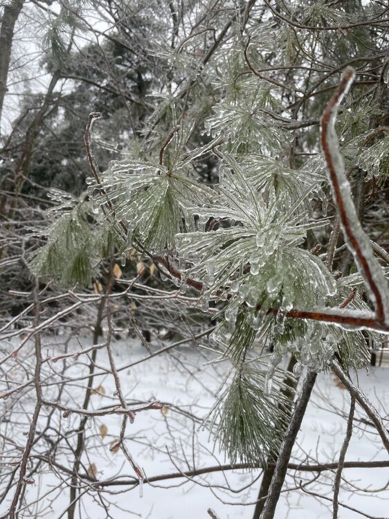
West of Albany, just south of Cooperstown and just south of the snow line.
We had sleet and freezing rain most of the morning and now sleet and snow.
Trees limbs and power lines getting saggy.
-
6
-
-
Would be great to have.
-
That was a nice line that went through last evening.
I saw there was a TOR warning south of Oneonta. Did anything get confirmed?
-
Grim discussion in the long range from Binghamton:
Our region continues to see a lack arctic high pressure systems
overall. These high pressure systems would have the potential to
shift the storm track further south, more favorably for snow.
The MJO looks to move into phases 2 and 3 which promote warmer
temperatures in mid to late January and storm tracks from the
southwest into the Great Lakes similar to this upcoming week. So
the possibility of the least snowiest January on record at
Binghamton (current snow 0.4 and the record 6.8 inches in 1973)
continues to be very real.
-
6 hours ago, CoolMikeWx said:
I'm wondering if we can bring this thread back this season as it was a ton of fun last season between the Buff /cuse / ADK / Albany people. And then a couple of us down starters and maybe a PA or two.. who love upstate weather.
If not, delete my post.
Sent from my SM-S908U using Tapatalk
That would be great.
Fire up a new one for 2023.
-
1
-
-
6 hours ago, BuffaloWeather said:
Canadian went nuts in last few runs. GFS has it too but a little further south and lower totals.

I don't want to go too far out on a limb here but thinking that 54 inches on Tug may not verify.
-
 1
1
-
-
2 hours ago, Flying MXZ said:
35° this morning with frozen dew on my windshield.
39 here.
Kids asking when the pellet stove goes on.
I told them at least another 2 weeks!
-
1
-
-
9 hours ago, BuffaloWeather said:


A little above normal temps in September is delightful. October as well.
-
1
-
-
17 hours ago, Flying MXZ said:
41° this morning was great!
You got me beat by several degrees, but this is another summer morning as it ought to be up here:
-
1
-
-
1 hour ago, brentrich said:
Funny thing is I'm there in discord with you guys. Now you see why this group is bunch of lying trolls.
I can almost always find the good in people.
With you though, not so much.
-
3
-
-
5 hours ago, wolfie09 said:
Damn that lake is a furnace..lol This is 2am Thursday into Friday...N/NW winds obviously..

I’m sitting sweltering in our non air conditioned living room and that 49F printed right on top of our house can’t come soon enough!
-
2
-
-
2 hours ago, TugHillMatt said:
Average highs in December are also still mild enough that "above average temps" more commonly can lead to rain... Whereas "above average" in January can still bring good chances of snow. Though, the above average Januarys of late haven't done so well in leading to snowy conditions. Below average temps in December can really work with those warmer lake temps to produce the good snows too.
Average highs for December 24/25 are around 55F in recent memory.
Usually with a touch of drizzle thrown in.
-
2
-
 1
1
-
-
3 hours ago, vortmax said:
IMO, it's been the best Spring/Summer we've had in a long time.
Right on.
-
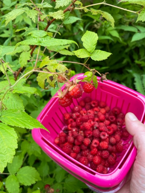
3 hours ago, Flying MXZ said:
0.4 out this way. Pretty dry summer for a change out this way.
Same amount here.
I feel like this summer is just right. We are getting enough rain for everything to grow and flourish but still having many beautiful summer days.
The wild raspberry crop is the best we have ever had:
-
4
-
-
1 hour ago, BuffaloWeather said:
CPC seasonal released. I think most here would lock that in quick
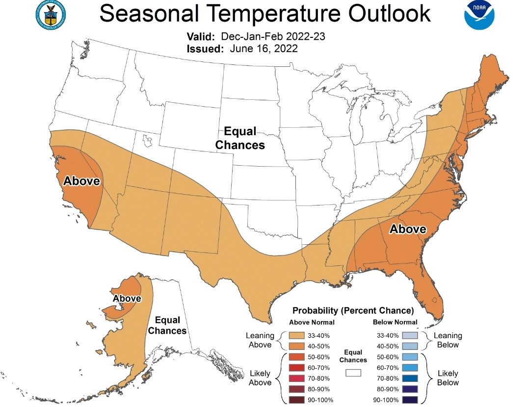
Great Lakes storm track?
-
1
-
-
A crisp 49F when I woke this morning under a clear blue sky.
What a spectacular summer it has been so far!
-
1
-
 1
1
-
-
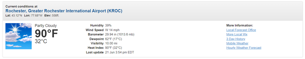
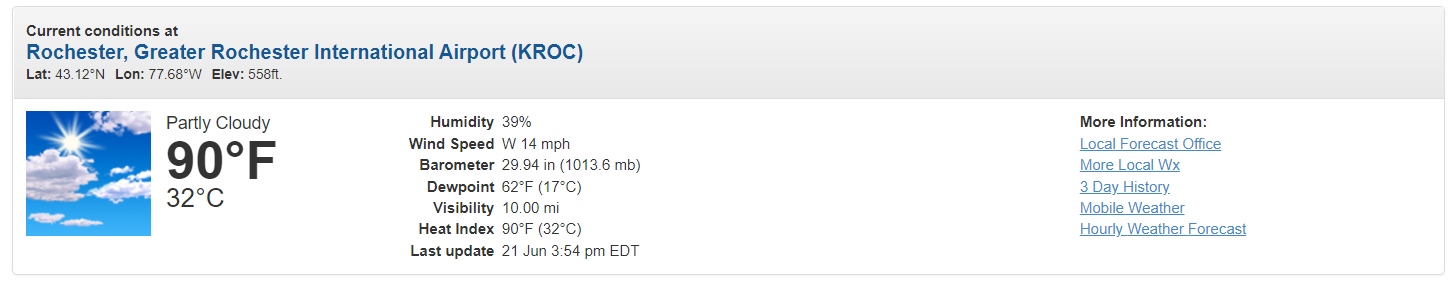
5 hours ago, TugHillMatt said:
Hmmm, check the facts there for your city, bro.
https://www.whec.com/rochester-ny-weather/first-alert-weather-in-depth-90-degree-days/6514995/
Dont go confusing him with actual facts.
-
3
-
3
-
-
We are trapped under the band of the unliving.
it just keeps pouring here. If only it were January!
Flood Advisory
Flood Advisory National Weather Service Binghamton NY 556 AM EDT Thu Jun 23 2022 NYC025-077-231300- /O.NEW.KBGM.FA.Y.0017.220623T0956Z-220623T1300Z/ /00000.N.ER.000000T0000Z.000000T0000Z.000000T0000Z.OO/ Delaware NY-Otsego NY- 556 AM EDT Thu Jun 23 2022 ...FLOOD ADVISORY IN EFFECT UNTIL 9 AM EDT THIS MORNING... * WHAT...Flooding caused by excessive rainfall is expected. * WHERE...A portion of central New York, including the following counties, Delaware and Otsego. * WHEN...Until 900 AM EDT. * IMPACTS...Minor flooding in low-lying and poor drainage areas. * ADDITIONAL DETAILS... - At 556 AM EDT, Doppler radar indicated moderate to heavy rain over the past two hours. Minor flooding is ongoing or expected to begin shortly in the advisory area. Between 1.5 and 2 inches of rain has fallen and an additional inch of rain is possible this morning.-
2
-
-
9 hours ago, Syrmax said:
That's some Pwnage right there. Dayum!
Dude somebody sucks at teh interwebs!
-
1
-
-
3 hours ago, vortmax said:
You were saying?
Incredible contrast in conditions. I went for a bicyle ride in knickers and a long sleeve jersey this morning.
I've been comfortable in sweatpants and a long sleeve shirt all afternoon long, moving around both inside and outside.
-
1 hour ago, BuffaloWeather said:
The up and down pattern looks to continue as we near the end of June

The heat continues to be focused west of I-81.
We have been considerably cooler out here to the east.
-
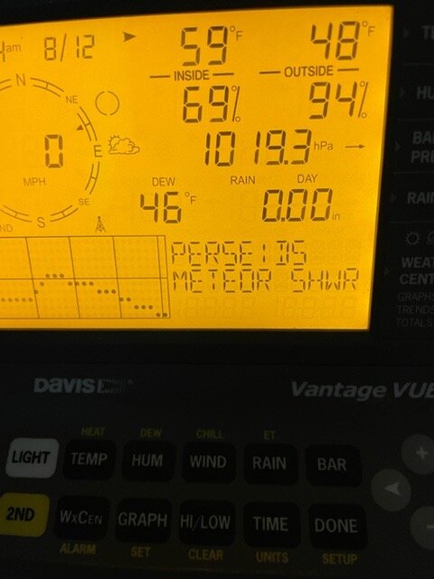
11 hours ago, Flying MXZ said:
35.7 this morning, 36.8 yesterday. Scattered frost in some fields this morning. It is the second half of June isn't it?
You really radiate there.
We only got down to 41 and 43 the last couple of mornings.
-
1
-
-
1 hour ago, BuffaloWeather said:
Glad I’m here lol
I knew that would make you feel better.
-
1
-

July 2024 Observations and Discussion
in New England
Posted
We’ve dealt with them for 23 years at our home in upstate NY…..this is the worst they have ever been.
Vicious.