

Damage In Tolland
-
Posts
104,611 -
Joined
Content Type
Profiles
Blogs
Forums
American Weather
Media Demo
Store
Gallery
Posts posted by Damage In Tolland
-
-
1 hour ago, ma blizzard said:
looks like a potent vortmax moving through though despite the QPF output
I wouldn't be that surprised to see flakes one more time .. of course any accumulation is a whole different animal. There have been some interesting looking Op GFS weenie runs the past couple days in the extended ( day 7+). Just for entertainment sake, there was a region wide snowstorm on the 0z GFS a couple nights back at the end of the run (for like 4/28).
Who knows .. maybe we are due for a late spring snow? Seems like there is a pattern with years ending in 7 (notwithstanding 2007) .. 1967, 1977, 1987, 1997 ..
Although its probably all moot and we end up with a cutoff low off shore with days of misery mist and onshore flow ..
If you look back in years that went nina to stronger nino..the springs featured wild fluctuations from big heat to late season snow events. In fact, I'm not 100% sure on this, but I think the May 77 storm was one of those years.
My guess is we'll have something to track over the next 3 weeks. Probably ends up nothing, but weenies will rise from some model runs
-
1 hour ago, Ginx snewx said:
that is a stretch less than .01 qpf temps in the mid 30s
That was like an old weenie post from that CT Blizz dude.
-
What a torch shaping up for Easter. Seems like every Easter has been cold in recent memory. 80's will be nice
Hams cooking on driveways.
-
I'd say summer is very very close 2nd to winter on here. Most posters like the warmth/ heat and tstorms. Spring is hands down a runaway for least favorite.
-
3 minutes ago, CoastalWx said:
Surprised Tippy hasn't chimed in for his warm air instability burst storm threats late Saturday night. Sort of has that look.
Nah. Napril
-
21 minutes ago, CoastalWx said:
Easter looks pretty darn warm. Maybe some strong aftn storms in NNE too. Looks like it cools off significantly after Sunday.
Nah... Pope said no yesterday . Said it's Napril so we can't get them
-
Take em up for Easter. Another day well into the 80's with dews in SNE.
Chocolate bunnies and eggs melted in baskets on tables?
-
Youre melt14 seems spot onTOLLAND COUNTY...
STAFFORD SPRINGS 18.5
UNION 13.3
HAMPTON 12.5
STAFFORD 12.3
VERNON 12.0
SOMERS 11.0
MANSFIELD 8.0
-
PNS differentmap shows 14 right over ur fanella
-
18.5 in Stafford Springs. If I recall there was 15-16 in Tolland but I was at my first house then
-
12 years ago. Obscene snow amounts in Maine. I worked this event at Upton but I can't recall why that screw zone occurred in SE CT.
That looks like massive subsidence/dryslot .Glad we weren't there
-
Disgusting. One of the worst storms ever. My Dad was working in Dalton Ma and was stunned at how little snow we had at home. I kept looking up at the sky literally seeing the flakes pounding high up in the air but never making it to the ground.
Up
-
My parents in in the valley portion of Somers only had about 3". The hills above them had over a foot....very sharp cutoff. Union had over 30" so that map is a little off. Elevation definitely played a role around here.
Where i grew up in Vernon we had 6 inches..but there was s much as 8 in higher spots in town
-
I know you SNE guys always talk about this storm, I cant seem to find a snowfall map for it. I think it was a big east slopes dump and downsloping pain in the valleys. I have no memory of it since it was a cold rain storm where I grew up in the Mid Atl CP. I thought it was mentioned Will made one, but maybe I'm not remembering that correctly.
EDIT:
Guess I didn't look hard enough, found this one:
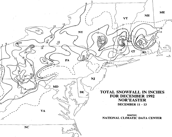
That's a really bad depiction of that storm. The Ct Valley itself had 6-10 depending on location. There was 16-18 ion this general area.
-
-
Notice how you never see 84 mentioned. It's either 91 or 90.
How can one get north of 91? Do tell
-
Barely.
Makes a difference sometimes
-
Yeah you want that look of what is going on from ORH northward...uniform topographic rises that can force a whole bunch of air up and over. The barrier needs to be sufficiently long to stop air from just going around the barrier, too.
Looking at where he is, on a more isolated bump at the edge of the chain, there's really nothing there that would indicate even on a southerly/SE/SW flow it would make much difference. There's still not a "wall" big enough to do anything appreciable in enhancing QPF in any way. You can see the "purple" areas on that map are probably the spots where any enhancement occurs.
I'm north of 84
-
I get more effects from land/sea convergence than he does from noslope at 1k.

-
When that wind direction it actually makes sense the higher totals were w and SW of Union as the enhanced echoes there fell downstream from wind direction.That was really a firehose band though. I didn't notice any enhancement other than a mesoscale band that probably was nothing to do with low level processes. You are actually at the end of the higher elevations in NE CT so using your logic..you should receive less than Union.
-
Maybe not in true sense.. But if you loop the radar from that storm.. It clearly shows the snow enhancing as that air hits the higher elevations of Eastern and then North eastern CT. Even over NW Ri a bitThere was no upslope really.
-
-
That firehose will always be in my top 3 faves. I remember worrying the whole time that the horrific dry slot over RI would make it here.. But instead we had some up slope component and kept pounding snow . I think it got very close to Central Windham county, but then filled back in relatively quickly
-
Xmas '02 was a great storm. We didn't get the jackpot in ORH like further NW did, but we had 13.5" of snow...started around 6-7am and went all day into the night ending in the overnight hours. There was actually a lot of sleet not too far SE...down in NE CT, N RI, and up near metro-southwest Boston.
Was sleet all day until late afternoon/early eve when it mixed and finally went to snow. Think we ended up with 7-8

Model Mehham
in New England
Posted
Doesn't seem overly wet . Scattered showers mid week. Euro has less than 1" thru day 10