Jns2183
-
Posts
5,799 -
Joined
-
Last visited
Content Type
Profiles
Blogs
Forums
American Weather
Media Demo
Store
Gallery
Everything posted by Jns2183
-
They actually shut it down permanently? Sent from my SM-G970U using Tapatalk
-
I thought I should probably drink less this new year. Now....maybe the answer is more Sent from my SM-G970U using Tapatalk
-
How the hell do you get some global conspiracy out of something I did as a weekend project because I found something interesting. I don't get the logic here. Sent from my SM-G970U using Tapatalk
-
What the hell are you talking about? Sent from my SM-G970U using Tapatalk
-
I'm just happy for many years in same location with a reasonable component record keeper and equipment. That's better than 95% out there. The other day I highlighted the insane rain differences between stations in a 5mile radius. Eventually I went back to what I could that had records for 5+ years and with some differences evened out where some they became greater. The ones that stood out I looked at other closer stations to try to verify some and kept average reading if they were within a mile. It wasnt super scientific but I definitely saw some microclimate variations that were greater than I thought. It definitely changed my priors on how variable and persistent they can be. I wish I could find some better research papers regarding them Sent from my SM-G970U using Tapatalk
-
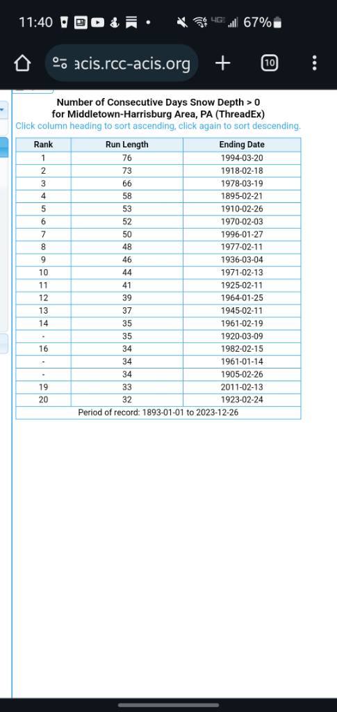
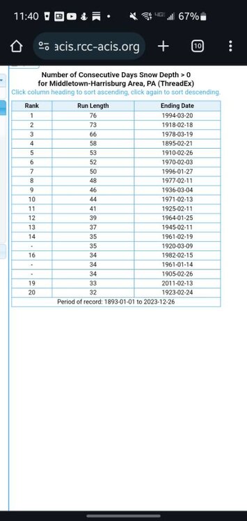
This also bothers me for your inherent faith in first order climate stations. I want to leave this here for you to read about the history of the Harrisburg station, but needless to say I would take any and all readings before 1941 as only reliable within an error range of probably 5-10x the acceptable range today if not more. Especially in the 1920s, since they decided for decades to take readings on top of buildings and construction from buildings around it had out sized effect on rain and wind readings. As well as it being on top of a building. At some point data was taken from two locations without it being always clear. But from its inception in 1888 till it's move to capital city airport in 1939 all reading were taken from atop buildings in various parts of Harrisburg. From 1939-1981 all readings were taken at what is now capital city airport. A couple years ago I did a deep dive regarding the persistent differences in rain, snow, temperature between capital city and KMDT, which shocked me at first due to them being so close by straight line distant. But you have far different microclimates and even far different extreme local effects from the positioning of the weather instruments. To say that Harrisburg weather data is superior just because it is a first order climate site after knowing it's history is laughable. I assume cheaters readings have been taken in a rural area for a long time consistently. As long as the record keepers were diligent in there record keeping and instrument calibration they are a valid and important climate data point. After actually investigating Harrisburg climate data and locations I feel there is no reliable way to properly compare any specific data from before 1941 to any data after. In general you can take a anything with an error of at least 25% +/- , and weather it rained, snowed, was sunny or cloudy. But specific amounts are a fools errand. How can you compare weather stations on top of buildings to one on the river in a sea of black asphalt with lots of planes aroundAt least after capital city has continued to keep data after a many year hiatus so that some sort of comparison to KMDT can be calibrated. Read for yourself https://www.google.com/url?sa=t&source=web&rct=j&opi=89978449&url=https://www.weather.gov/media/ctp/ClimateStationHistory/Harrisburg%2520LCD%2520Site%2520History.pdf&ved=2ahUKEwj95JLmurCDAxVGfzABHULLClkQFnoECB0QAQ&usg=AOvVaw3o9ZqjV8uN7wryJgySUuZ2 Sent from my SM-G970U using Tapatalk
-
I'm having an enjoyable time watching the spawn of Penn state play a messy game in crap weather while enjoying a fire and double IPA Sent from my SM-G970U using Tapatalk
-
Is the rain heavy Sent from my SM-G970U using Tapatalk
-
But the Philly area got pasted from big storms during that period Sent from my SM-G970U using Tapatalk
-
Here's Harrisburg Sent from my SM-G970U using Tapatalk
-
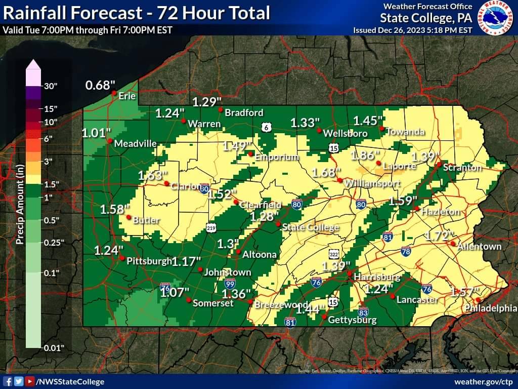
New rainfall map from 630pm forward Sent from my SM-G970U using Tapatalk

-
The 1960s averaged 8 storms of 3" plus per year for the decade, but never saw a storm with more than 18" Sent from my SM-G970U using Tapatalk
-
That one hit wonder takes the cake for me. Us laughing at the nam a few days prior for it's insanity only to be correct. The SREFS snowfall curve going exponential in the 36 hours beforehand which supported the NAM fantasy amounts. The local weather stations being off 16"-30" a day before. And mostly that route 81 deathband that setup stationary for 6-10 hours. I doubt I will have another storm like it in my life. To top it off it was the only snow of the season. Sent from my SM-G970U using Tapatalk
-
Bad snow streaks seem to end on a boom at least. Closest I found was 5 year snow ending 12/31/2014 State College 190 Philly 176 Harrisburg 142 Still that's ridiculous Sent from my SM-G970U using Tapatalk
-
Didn't Philly average more snow than state college for the 2010 decade. I remember some ridiculous statistic like that. Sent from my SM-G970U using Tapatalk
-
I think you very well know my thoughts probably, haha. For years I wondered about these magical winters my parents and their friends all spoke about when younger. Than I found out they were all born between 1956-1960, then stumbled upon just how weird and crazy the 1960s were in regard to snow. The closest we were to something so strange was rainfall in 2011 with 73" and 2018 with 67" as compared to previous high of 59" due to angels in 1972. But for that comparison to hold true the totals would have had to be 89" and 82" with 2 more years in the 2010's with 60"+ of rain. For a decade the 1960s were a once in 50 to 100 decade (so 500 to 1000 years). People who had there childhood in the 60's have such a distorted view of snow. Sent from my SM-G970U using Tapatalk
-
Hasn't that happened every December for last decade which would make it normal. Sent from my SM-G970U using Tapatalk
-
Are you foggy down there Sent from my SM-G970U using Tapatalk
-
They actually rose Harrisburg to 1.72" from 1.68". But I was looking at the weather briefing the whole time and not the zonal forcast Sent from my SM-G970U using Tapatalk
-
1.5" would put me over 5" for the month Sent from my SM-G970U using Tapatalk
-
Which locals? Sent from my SM-G970U using Tapatalk
-
This rain has to a god send for the heavy drought inflicted areas near you. Sent from my SM-G970U using Tapatalk
-
Looks like they are calling for 1.68" of rain by Thu morning in Harrisburg. It's going to be spread out over multiple days though. I get a feeling we are going to be socked in with drizzle and fog for most of the time it's not raining Sent from my SM-G970U using Tapatalk
-
That is some heavy heavy rain Sent from my SM-G970U using Tapatalk
-
Haha, I'd rather make my mortgage for a year Sent from my SM-G970U using Tapatalk