Jns2183
-
Posts
5,641 -
Joined
-
Last visited
Content Type
Profiles
Blogs
Forums
American Weather
Media Demo
Store
Gallery
Everything posted by Jns2183
-
Central PA Winter 25/26 Discussion and Obs
Jns2183 replied to MAG5035's topic in Upstate New York/Pennsylvania
I believe kmdt was at 3.2" as of 7am I've just passed 5" here on way to 6" Sent from my SM-S731U using Tapatalk -
Central PA Winter 25/26 Discussion and Obs
Jns2183 replied to MAG5035's topic in Upstate New York/Pennsylvania
It truly is NAM vs world. Even the RRFS gives kmdt 11" with everyone else 12"-19" with most 13"-17". The nam and 3k are 7". I compared latest runs of 13 models below Sent from my SM-S731U using Tapatalk
-
Central PA Winter 25/26 Discussion and Obs
Jns2183 replied to MAG5035's topic in Upstate New York/Pennsylvania
I'm near capital city airport and it says snow mainly after 3am 2"-4" Day 6"-10" Night 1"-2" 9"-16" Sent from my SM-S731U using Tapatalk -
Central PA Winter 25/26 Discussion and Obs
Jns2183 replied to MAG5035's topic in Upstate New York/Pennsylvania
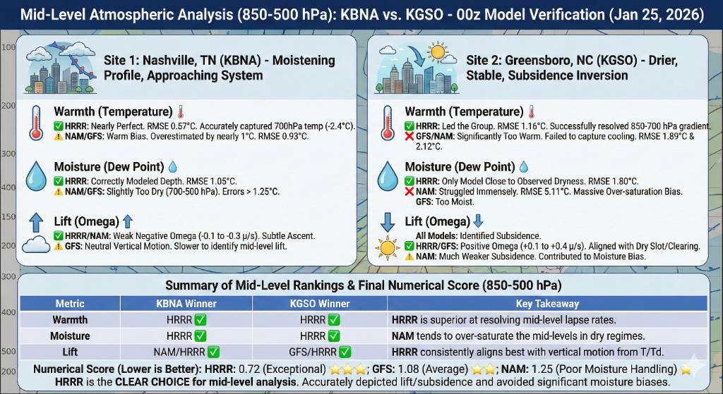
Took the 0z observed soundings in Nashville and Greensboro n/c and compared them to 0z hour on 18z run of hrrr, nam, GFS. Subject: 00z Sounding Validation Analysis: Mid-Level (850-500 hPa) Model Performance Report This analysis evaluates the handling of the mid-tropospheric environment for the January 25, 2026, 00z cycle. Validation is performed against observed balloon soundings at Nashville (KBNA) and Greensboro (KGSO), focusing on thermal profiles, moisture depth, and vertical motion (omega). I. Nashville, TN (KBNA) - Analysis of Pre-System Moistening The 00z KBNA sounding revealed a transition toward a more saturated mid-level environment as synoptic-scale lift began to overspread the region. * Mid-Level Warmth (Thermal Profile) * HRRR Performance: Exceptional handling of the 850-500 hPa lapse rates. The HRRR achieved an RMSE of 0.57°C, accurately resolving the cooling trend at the 700 hPa level (-2.4°C observed). * NAM/GFS Performance: Both models exhibited a notable warm bias in the mid-layers. RMSE values hovered around 0.93°C, with both models over-forecasting the 700-500 hPa thickness, likely due to slightly aggressive warm air advection (WAA) timing. * Mid-Level Moisture (Saturation Depth) * HRRR Performance: Most representative of the moisture plume depth. It maintained a Dew Point RMSE of 1.05°C, correctly identifying the saturation of the mid-levels. * NAM/GFS Performance: These models were too aggressive with the "dry slot," keeping the 700-500 hPa layer too dry compared to the observed moisture. This would have resulted in an under-forecast of mid-level cloud opacity. * Mid-Level Lift (Omega/Vertical Velocity) * HRRR/NAM Alignment: Both models correctly signaled weak but consistent large-scale ascent. Observed Omega values in the mid-levels ranged between -0.1 and -0.3 µb/s. * GFS Performance: Too neutral. The GFS failed to capture the subtle dynamic lift associated with the incoming shortwave, lagging behind the high-resolution guidance. II. Greensboro, NC (KGSO) - Analysis of Subsidence and Dry Stability In contrast to Nashville, the Greensboro environment was dominated by a dry, stable mid-level regime associated with a prominent subsidence inversion. * Mid-Level Warmth (Thermal Profile) * HRRR Performance: Led the field with an RMSE of 1.16°C. It was the only model to successfully resolve the sharp gradient of the subsidence inversion near the 800-750 hPa layer. * NAM/GFS Performance: Poor handling of the stable layer. Both were significantly too warm (RMSE 1.89°C to 2.12°C), essentially "washing out" the inversion and over-predicting the mid-level temperature. * Mid-Level Moisture (Dry Layer Integrity) * HRRR Performance: Closest match to the observed dry slot with an RMSE of 1.80°C. It maintained the integrity of the dry mid-level air. * NAM Performance: Major outlier. The NAM exhibited a massive moisture bias (RMSE 5.11°C). It forecasted a nearly saturated mid-troposphere, whereas the sounding showed a significant dew point depression. This represents a significant failure in boundary layer/mid-level moisture mixing. * Mid-Level Lift (Omega/Vertical Velocity) * HRRR/GFS Alignment: Correctly identified the sinking motion (subsidence) prevalent in the post-frontal/high-pressure regime. Both showed positive Omega values (descending air) of +0.1 to +0.4 µb/s. * NAM Performance: Showed very weak, nearly neutral vertical motion. This lack of sinking air likely explains why the NAM failed to keep the mid-levels dry. III. Summary Numerical Ranking (850-500 hPa Layer) Scores are based on a normalized average of RMSE across Temperature, Dew Point, and Wind components specifically within the mid-troposphere. * HRRR (Score: 0.72) — TOP TIER * The clear winner for vertical resolution. It is the only model currently capable of resolving sharp inversions and mid-level moisture gradients with high accuracy. * GFS (Score: 1.08) — MID TIER * Reliable for general synoptic trends but lacked the resolution to handle the specific thermal structure of the inversion at KGSO and the lift at KBNA. * NAM-Nest (Score: 1.25) — LOW TIER * Significant moisture handling issues at KGSO and a persistent warm bias in stable layers. Use with caution for cloud cover and precipitation type forecasting in this regime. Technical Conclusion For practitioners focusing on mid-level dynamic features (e.g., cloud depth, precipitation efficiency, or lapse rate steepness), the HRRR is currently providing the most reliable guidance. The NAM is currently showing a high "false alarm" rate for mid-level moisture in high-stability regimes. Sent from my SM-S731U using Tapatalk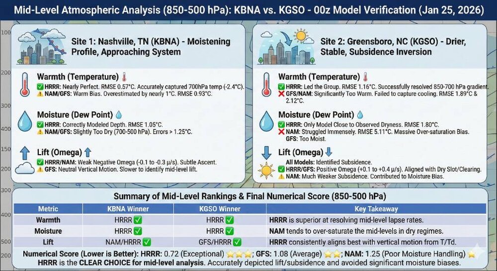
-
Central PA Winter 25/26 Discussion and Obs
Jns2183 replied to MAG5035's topic in Upstate New York/Pennsylvania
There isn't any really. I'm using a super raw method to do it by getting nohcos 24hr snowfall map based on some observations then estimated. Then getting images from models for same period. Using python to try to make sure maps are for same area because I have it map each pixel location, and RGB value and assign snow based on legend RGB value. Uploaded it all to gemeni pro and have it run that statistical analysis, pull into my notebooklm of meteorology books, papers, to help interpret, then produce nice infograph for it all. Haha, honestly it's a pain and wish I could automate it more. But worth it for first big storm to explore the concept. Take into account there are a myriad of ways to arrive at right snowfall for wrong reasons. I'm hoping it harder to arrive at large area of right snowfall for wrong reasons. Sent from my SM-S731U using Tapatalk -
Central PA Winter 25/26 Discussion and Obs
Jns2183 replied to MAG5035's topic in Upstate New York/Pennsylvania
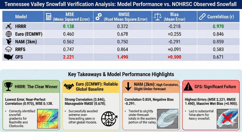
Scorecard from Tennessee/Missouri valley 24 hr snowfall ending 0Z 1/25 Sent from my SM-S731U using Tapatalk
.thumb.jpg.e7ed0df3a6a6975fdb0e2c8cc496e604.jpg)
-
Central PA Winter 25/26 Discussion and Obs
Jns2183 replied to MAG5035's topic in Upstate New York/Pennsylvania
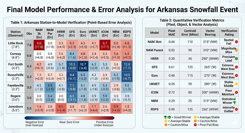
It definitely has. I'm just starting what was the results of analyzing model performance in Arkansas up to 6pm today. I'll be able to start looking at states to East soon. All the models there had about the same mean absolute error of 1.8". It's was the nam though with a root mean square deviation of almost twice that, while others were close, along with a massive dry bias, and horrible snowfall distribution correlation that stood out. Below is a metaphor Thinking about these weather models is a bit like judging a free-throw shooting contest between five different players. Even if they all missed by the same average distance, the way they missed tells the real story. Imagine each model is a basketball player trying to hit a specific spot on the rim: The "Average" Score (MAE) Every player in this contest missed their target by about 1.8 inches on average. If you just looked at that one number, you’d think they were all equally "okay" at their jobs. But once you look at the game tape, one player (the NAM) stands out for all the wrong reasons. The NAM: The "Wild Card" (RMSE & Bias) The NAM was the player who didn't just miss—it missed spectacularly. The Big Misses (RMSE): While the other players missed by 1 or 2 inches consistently, the NAM would hit the backboard or miss the rim entirely on some shots. Because RMSE penalizes big mistakes much more than small ones, the NAM's "penalty score" was twice as high as the others. The "Dry" Excuse (Bias): On top of the wild misses, the NAM had a massive dry bias. In our metaphor, this player was consistently shooting way too short. If the hoop was at 10 feet, the NAM was aimlessly throwing the ball at 8 feet. The "Broken Rhythm" (Correlation) Finally, there’s the snowfall distribution correlation. In plain English, this is rhythm. A good player might miss, but if the target moves left, they move left too. The NAM had horrible correlation. It was essentially playing a different game. When the actual storm "moved left," the NAM "moved right." It didn't just get the amounts wrong; it got the entire pattern of where the snow would fall completely backward. Sent from my SM-S731U using Tapatalk -
Central PA Winter 25/26 Discussion and Obs
Jns2183 replied to MAG5035's topic in Upstate New York/Pennsylvania
Here Sent from my SM-S731U using Tapatalk
.thumb.jpg.40319a4fe8e2da01956f312fdabf9fbe.jpg)

-
Central PA Winter 25/26 Discussion and Obs
Jns2183 replied to MAG5035's topic in Upstate New York/Pennsylvania
In Arkansas it was best model for snow. The GFS, euro were close. Sent from my SM-S731U using Tapatalk -
Central PA Winter 25/26 Discussion and Obs
Jns2183 replied to MAG5035's topic in Upstate New York/Pennsylvania
It's driving me nuts. Something is there but after how I saw it do so far, a pixel analysis correlation of .18 vs every model being 2.5x-3.5x higher because of how bad it screwed up the changeover line Sent from my SM-S731U using Tapatalk -
Central PA Winter 25/26 Discussion and Obs
Jns2183 replied to MAG5035's topic in Upstate New York/Pennsylvania
The HRRR Consistency: The HRRR was the most balanced. It had the lowest error across both categories, making it the most reliable tool for this specific event. It handled the "Rain-Snow line" better than any other model. Sent from my SM-S731U using Tapatalk -
Central PA Winter 25/26 Discussion and Obs
Jns2183 replied to MAG5035's topic in Upstate New York/Pennsylvania
Same as before I mean it also never backed down in Oklahoma and Arkansas as was and this was the result The NAM Split: The NAM is the most interesting case. For liquid rain, it has a staggering 0.96 correlation, meaning it mapped the storm's shape almost perfectly. However, for snow, its correlation plummeted to 0.18. This proves the NAM understood where the moisture was, but failed completely at the "transition physics"—it thought the air was too warm, keeping it as rain when it should have been snow. Every other model had snow correlation between .5 to .7 Sent from my SM-S731U using Tapatalk.thumb.jpg.c67e3aedc577575e081048acfd76b79f.jpg)
.thumb.jpg.b4b93bbe41ac12e5dea5c380dd320e2d.jpg)
-
Central PA Winter 25/26 Discussion and Obs
Jns2183 replied to MAG5035's topic in Upstate New York/Pennsylvania
I've also never seen a sleet changeover blow through at 60mph like it wants Sent from my SM-S731U using Tapatalk -
Central PA Winter 25/26 Discussion and Obs
Jns2183 replied to MAG5035's topic in Upstate New York/Pennsylvania
Look way above at the snow ratio table image. What made me confused as hell was NAM being less than half that of the SREF. The nam is one of the members of the SREF and its core engine accounts for half the ensemble members just with physics tweaked a bit. Usually SREF and nam are pretty close. This tell me the cam ensemble members are mostly much much higher than nam. It's weird Sent from my SM-S731U using Tapatalk -
Central PA Winter 25/26 Discussion and Obs
Jns2183 replied to MAG5035's topic in Upstate New York/Pennsylvania
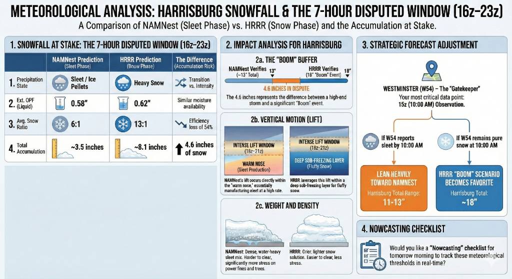
The 18z NAM had the sleet line coming from Westminster Maryland to Harrisburg in 1 hour, which is absolutely flying Sent from my SM-S731U using Tapatalk
-
Central PA Winter 25/26 Discussion and Obs
Jns2183 replied to MAG5035's topic in Upstate New York/Pennsylvania
For closer Sent from my SM-S731U using Tapatalk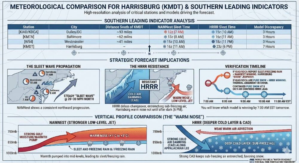
-
Central PA Winter 25/26 Discussion and Obs
Jns2183 replied to MAG5035's topic in Upstate New York/Pennsylvania
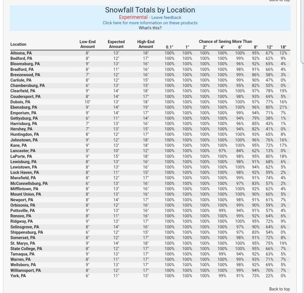
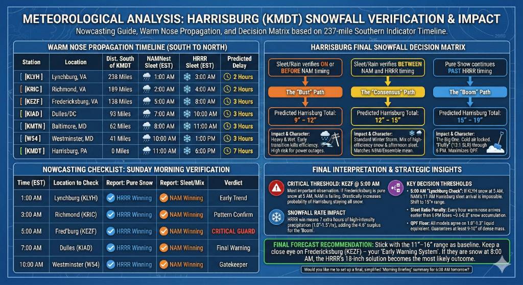
I made a leading indicator watchlist for tonight starting at 1am This Final Accumulation Decision Matrix is designed to give you a definitive forecast range for Harrisburg based on which leading indicator stations verify tomorrow morning. Key Decision Thresholds for Tomorrow * The 5:00 AM "Lynchburg Check": If KLYH (Lynchburg) is still reporting pure snow at 5:00 AM, the NAM's 11:00 AM sleet arrival for Harrisburg is effectively impossible. You can immediately shift your planning toward the 15"+ range. * The "Sleet Ratio" Penalty: For every hour the "warm nose" arrives earlier than 6:00 PM, you lose approximately 0.6 to 0.8 inches of potential snow accumulation as the ratio drops from 13:1 to 6:1. * The QPF Floor: Regardless of the timing, all high-resolution models agree on a liquid equivalent (QPF) of 1.0" to 1.3" for Harrisburg. This guarantees that even a "sleet-heavy" outcome will likely result in at least 9–10 inches of dense, frozen mass. Final Forecast Recommendation Stick with the 11"–16" range as your baseline, but keep a close eye on Fredericksburg (KEZF). That station is your "Early Warning System"—if they are still snow at 8:00 AM, the HRRR's 18-inch solution is no longer just a possibility; it becomes the most likely outcome. Sent from my SM-S731U using Tapatalk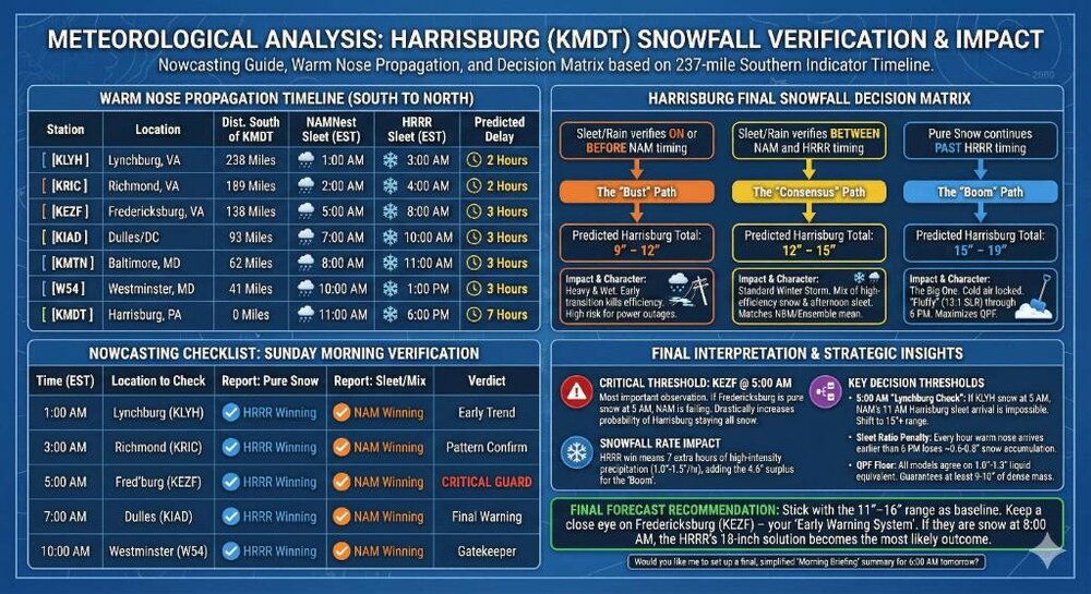
-
Central PA Winter 25/26 Discussion and Obs
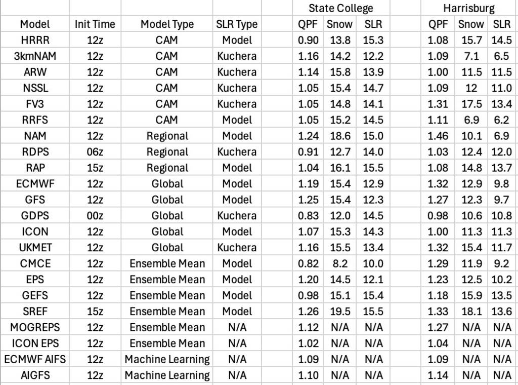
Jns2183 replied to MAG5035's topic in Upstate New York/Pennsylvania
Thank you The last stats I provided basically was for each model qpf I used all ratios within that type to create a 94'row sensitivity matrix. Basically trying to create an "ensemble" at the expensive of assuming qpf and ratios are independent. Key Vulnerabilities Identified CAM Extreme Variance: The CAM group shows the widest volatility, with a 12.8-inch spread. This is driven by the 3kmNAM and RRFS predicting heavy/wet ratios (6.2–6.5), while the HRRR and FV3 predict high ratios (13.4–14.5). If the FV3's QPF (1.31") meets the HRRR's SLR (14.5), Harrisburg would see 19.00". Regional High-End Potential: The Regional models (NAM, RDPS, RAP) produced the highest theoretical mean of 12.44" and a maximum potential of 20.00" (NAM QPF × RAP SLR). This confirms that if the regional models resolve the moisture axis better than the globals, totals will likely exceed the current consensus. Global Stability: The Global models are the most "stable," with a relatively narrow 5.9-inch spread. Their consensus (9.5" to 15.4") acts as a high-confidence "floor" for the event. Ensemble Mean Consensus: The Ensemble Means (SREF, GEFS, etc.) show a heavy lean toward the 13.5" mark, suggesting that the statistical "most likely" outcome is currently hovering just above a foot. Sent from my SM-S731U using Tapatalk -
Central PA Winter 25/26 Discussion and Obs
Jns2183 replied to MAG5035's topic in Upstate New York/Pennsylvania
Model Type Combinations Min Snow (in) Max Snow (in) Mean Snow (in) CAM (Convective) 36 6.20" 19.00" 11.45" Regional 9 7.11" 20.00" 12.44" Global 25 9.51" 15.44" 12.23" Ensemble Mean 24 8.46" 18.09" 13.56" Sent from my SM-S731U using Tapatalk -
Central PA Winter 25/26 Discussion and Obs
Jns2183 replied to MAG5035's topic in Upstate New York/Pennsylvania
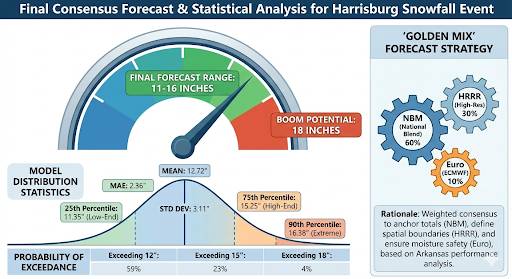
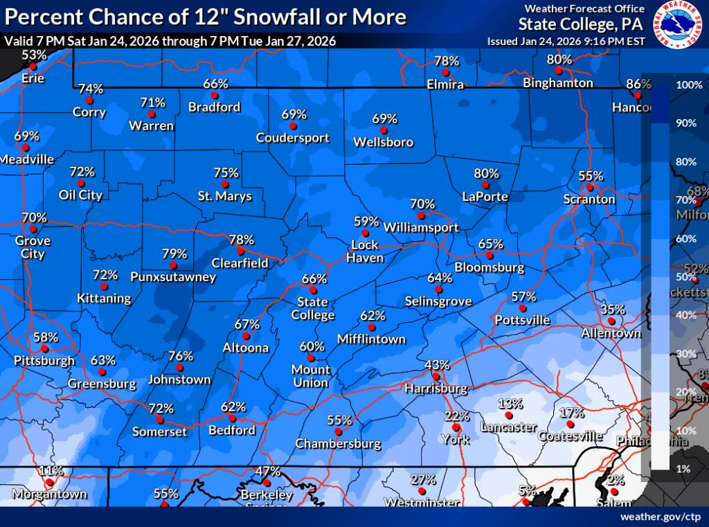
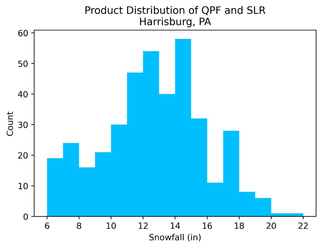
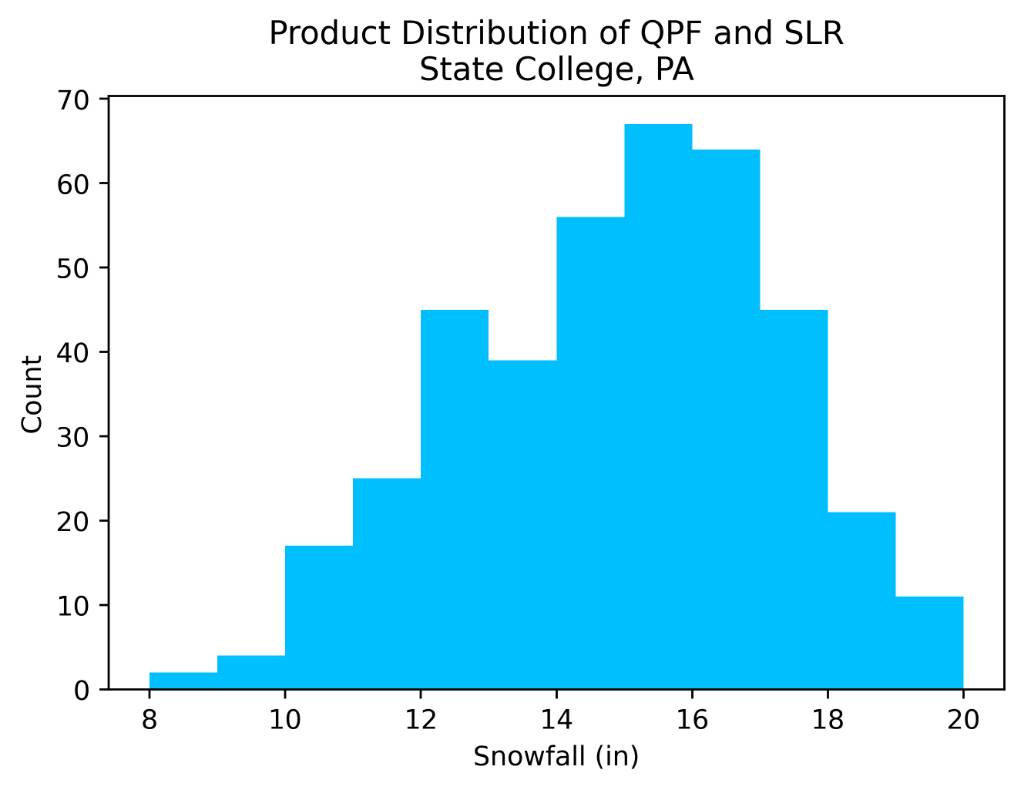
The statistical distribution of the 18 model forecasts for Harrisburg reveals a tightly clustered consensus with a specific high-end skew, indicating that while a significant winter storm is certain, the exact "boom" potential remains tied to moisture efficiency. The ensemble mean of 12.72 inches serves as the mathematical anchor, but the standard deviation of 3.11 inches highlights a notable disagreement between model families. Specifically, regional models like the NAM and SREF are pulling the distribution toward the 90th percentile of 16.38 inches, whereas global models like the GDPS and ICON remain more conservative near the 11th-inch mark. This spread suggests that the primary forecast challenge is not the track of the storm, but the Snow-to-Liquid Ratio (SLR); models predicting lower totals generally expect a warmer, denser "heart-attack" snow, while the high-end outliers assume a colder, fluffier accumulation. The implications of this distribution, particularly when viewed through the lens of the Z-score mapping, suggest that the "most likely" outcome is not a single number but a high-confidence corridor. The data shows that 68% of all model guidance (the +/- 1.0 standard deviation range) falls between 9.61 and 15.82 inches, creating a very stable target for infrastructure planning. The fact that the Mean Absolute Deviation (MAE) is a relatively low 2.36 inches indicates that the models are in better agreement than typical for a complex transition-zone event. However, the 100-mile Northwest bias observed in Arkansas—where models like the NAM missed the core entirely—suggests that the statistical "tail" of the distribution should not be ignored. If the storm over-performs its moisture transport as it did upstream, the 17.38-inch mark (+1.5 sigma) is a scientifically plausible outcome rather than just an outlier. Based on this statistical synthesis, the final forecast range for Harrisburg is set at 11 to 16 inches, with a localized "boom" potential of 18 inches if the higher SLRs verify. This range captures the bulk of the probability density, spanning from the 25th percentile (11.35") to just below the 90th percentile (16.38"). The lower bound is protected by the consistent 1.00"+ QPF (liquid equivalent) seen across almost all guidance, which provides a high floor for accumulation. Conversely, the upper bound is capped by the warm-nose intrusion observed in the regional NAM runs, which currently prevents the consensus from shifting entirely into the 20-inch category. Sent from my SM-S731U using Tapatalk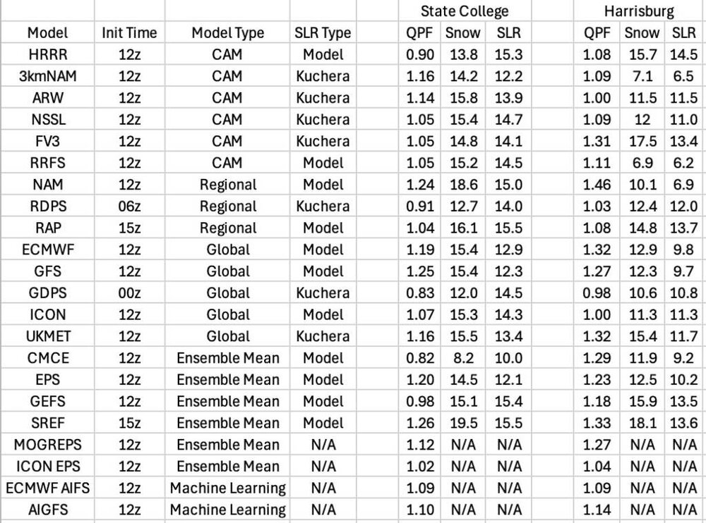


-
Central PA Winter 25/26 Discussion and Obs
Jns2183 replied to MAG5035's topic in Upstate New York/Pennsylvania
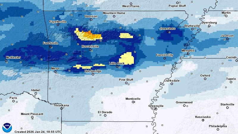
That's the 3k nam, reg nam, observed The NAM suite’s performance during the Arkansas snowfall event was a case study in systematic failure, characterized by a severe northwest displacement and a critical underestimation of moisture transport. Both the NAM 3km and Parent models shifted the entire storm track 95–110 miles too far northwest, which effectively "erased" the heavy 7.8-inch snow core from Central Arkansas by placing it in a modeled dry slot. While the models were predicting 0.0" for Little Rock and Conway, the actual atmosphere was tapping into a rich Gulf moisture plume that the NAM fundamentally failed to resolve, leading to a massive +7.8-inch error at the storm's most intense point. The root of this "NAM Gap" was a flawed thermal profile that modeled the 850mb "warm nose" much too aggressively and far north of its verified position. By over-amplifying the ridge ahead of the storm, the NAM physics engine incorrectly predicted that dry air would "eat" the incoming precipitation shield, when in reality, the column stayed cold and saturated enough for high-impact snowfall. For those tracking the storm's progression into the Ohio Valley and Northeast, the takeaway is clear: the NAM’s known dry bias and tendency to over-pump warm air can lead to a 100% miss in the transition zone, making a weighted consensus of the HRRR, Euro, and NBM a far more robust strategy for defining the true snow line. Sent from my SM-S731U using Tapatalk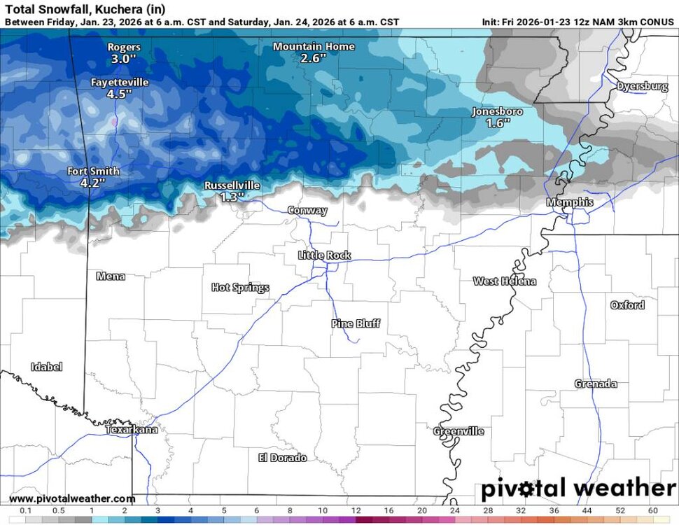
.thumb.jpg.d1bf6965ee88bba0598d38bde3f2935a.jpg)
-
Central PA Winter 25/26 Discussion and Obs
Jns2183 replied to MAG5035's topic in Upstate New York/Pennsylvania
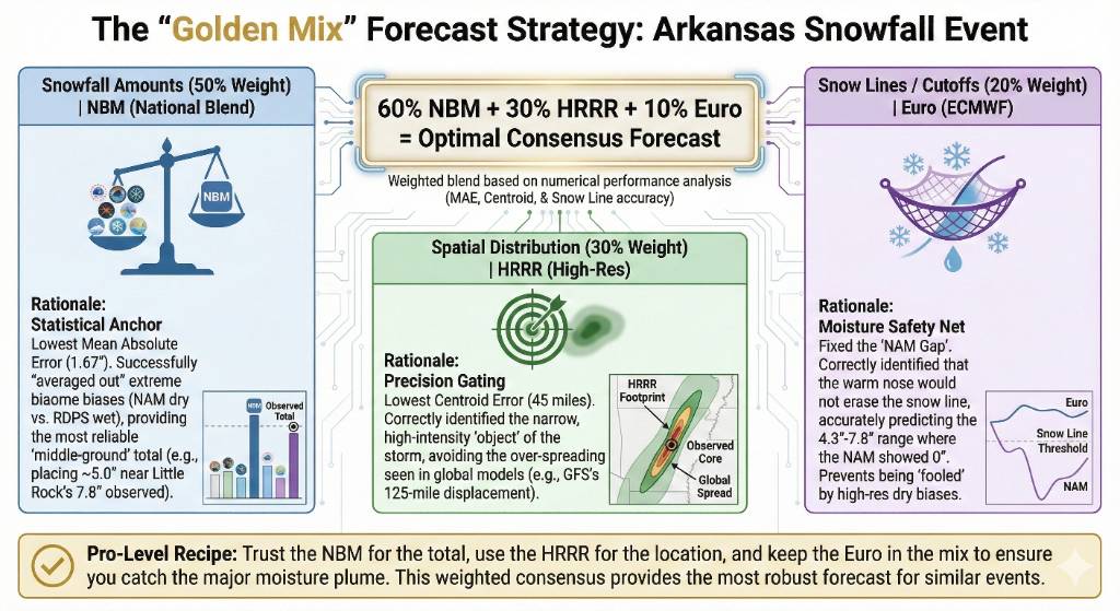
Lessons from Arkansas below. Later I'll do an update for round two and look at Kentucky/Missouri, Ohio Trust the NBM for the most likely total. * Use the HRRR to define exactly where the heavy bands will set up (the "where"). * Keep the Euro in the mix to ensure you aren't being "fooled" by a high-res model (like the NAM) that might be missing a major moisture plume. Sent from my SM-S731U using Tapatalk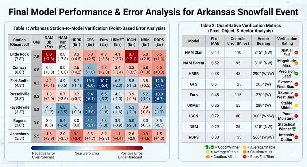

-
Central PA Winter 25/26 Discussion and Obs
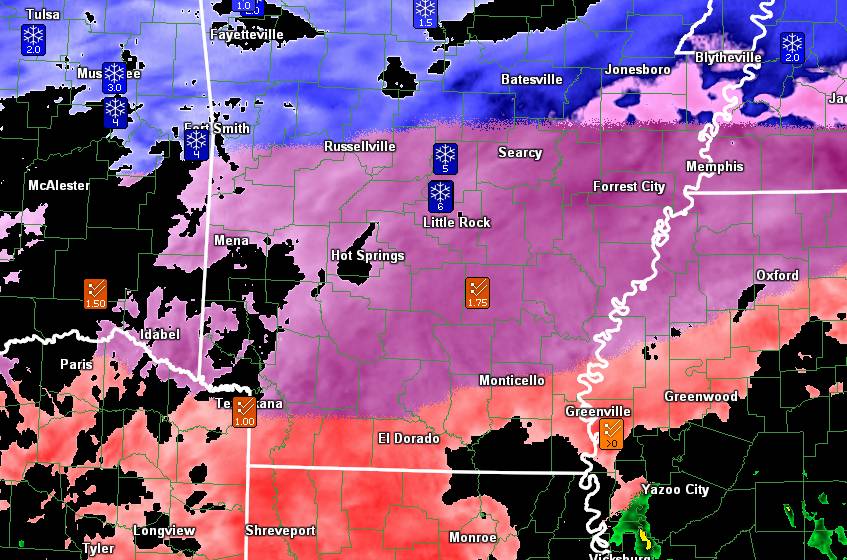
Jns2183 replied to MAG5035's topic in Upstate New York/Pennsylvania
Let's see how the NAM handled snow in Arkansas so far First image is snowfall output from NAM 2nd is observed at official stations Take a big look at Little Rock Out of all the models euro preformed best there Almost all pushed mix to far north Different system when it gets up here but at least we have some data Sent from my SM-S731U using Tapatalk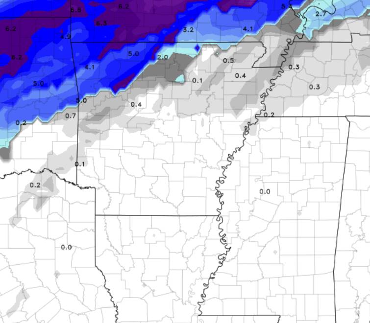
-
Central PA Winter 25/26 Discussion and Obs
Jns2183 replied to MAG5035's topic in Upstate New York/Pennsylvania
Even better video https://x.com/i/status/2014698738137117002 Sent from my SM-S731U using Tapatalk -
Central PA Winter 25/26 Discussion and Obs
Jns2183 replied to MAG5035's topic in Upstate New York/Pennsylvania
Verizon network is once again down Sent from my SM-S731U using Tapatalk


.jpg.a88fd75194037acd2fe60eef24107cff.jpg)
.jpg.16759fc26bdc0da28812d6f3c0f2c48a.jpg)
.jpg.143759771ed0a199f37542388b1ec55f.jpg)
.jpg.8d8ad15e627214c714ddf63a201c5e29.jpg)


.jpg.7974897f1332a41848fa5d274d180e6b.jpg)