

Natester
-
Posts
1,221 -
Joined
-
Last visited
Content Type
Profiles
Blogs
Forums
American Weather
Media Demo
Store
Gallery
Posts posted by Natester
-
-
You know, I would be really surprised if Cedar Rapids got more snow than the Chicago suburbs.
-
 1
1
-
-
1 minute ago, mimillman said:
I just want to know how much snow the RAP shows for Cedar Rapids
About 2.5 inches. The 16z HRRR has only an inch for Cedar Rapids. Both will bust low, especially the HRRR.
-
 1
1
-
-
Radar trends for Cedar Rapids look promising. Light snow here, was moderate for about 15-20 minutes.
-
RAP and HRRR only giving Cedar Rapids 2 to 2.5 inches of snow.
EDIT: Spitting flurries here now.
-
 1
1
-
-
I very highly doubt that O'Hare will hit 5 inches of snow let alone go above that. Models only show a few inches for Chicago.
-
1
-
-
Lowering my call to 1 inch of snow. However, I expect to get nothing just like on 11/25/2018. Next!
EDIT: Nam 3k jumped back north and gives CR over 6 inches. Not sure if I believe that.
-
2
-
-
Both of the NAMs still bullish on amounts. Slightly amped too.
-
1
-
-
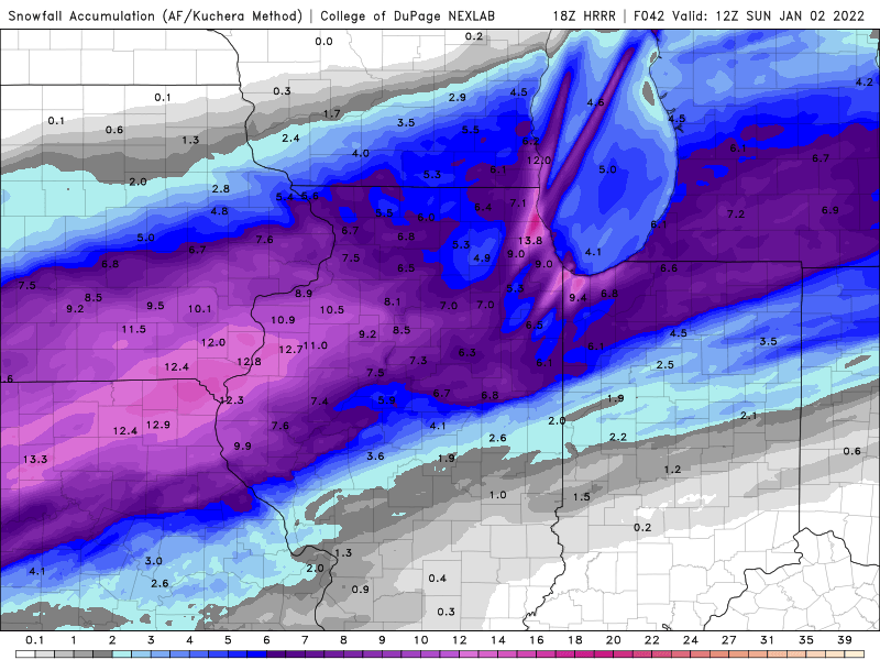
0z HRRR still gives Cedar Rapids a decent amount of snow even if the moderate/heavy snow only lasts a few hours. HRRR shows 4-5 inches for Cedar Rapids.
-
1
-
-
I'm anticipating the northern tier of counties in Iowa under a WSW to be downgraded to an advisory.
-
1
-
-
I'm expecting 0z HRRR to really cut down on the totals, perhaps giving CR only 2-3 inches.
-
1
-
-
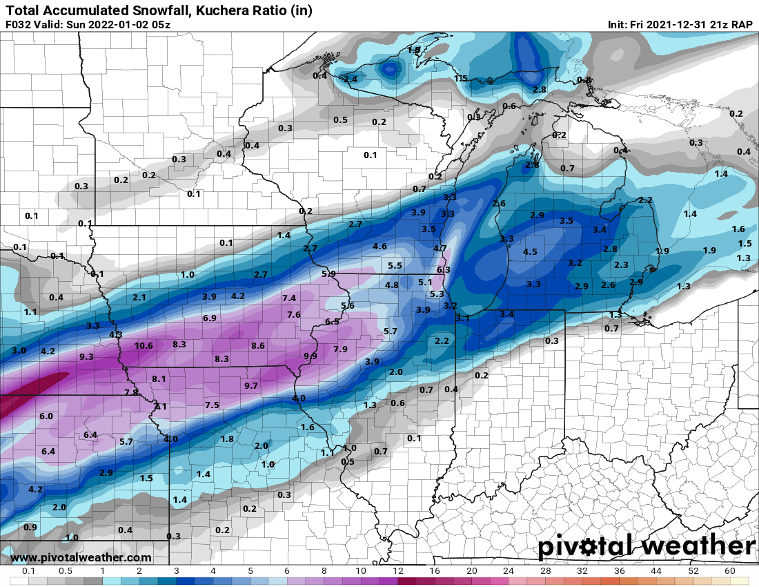
21z RAP snow totals. More down to earth now.

-
2
-
-
18z RGEM and 18z GFS a tick south of 12z.
-
In other news, freezing drizzle is causing alot of travel problems in central and western Iowa. Reports of many crashes. Roads in eastern Iowa are so far wet according to the Iowa 511 road conditions map. The NAM and the HRRR picked up the freezing drizzle potential a couple days ago.
-
4 minutes ago, hlcater said:
Respectfully, tossing a model simply because it’s too far north isn’t really worthwhile. I agree that it probably is, but the issue arises when you’ve made what is essentially the same post 15 times in the same thread without providing any reasoning as to why other than “too far north”.
For example, you could make the argument that dry NEly flow eats away at low/mid level RH and prevents precip from spreading as far north as some models think it will. This is certainly the case for the models showing heavy snow to the hwy 20 corridor and may well be the case for Cedar Rapids as well, though seems unlikely from preventing us from seeing at least 4.”
Yeah, I forgot about the dry air. Although the southern end of the heavy snow axis is in extreme northern Missouri as shown here.
-
 1
1
-
-
The 18z NAM is an easy toss. Too far north with the heavy snow axis. Doesn't ramp up the system, though.
-
The only good thing about this is the long duration light snows. HRRR predicts 5.5 inches here but I'm skeptical.
-
1
-
-
5 minutes ago, hlcater said:
HRRR coming south again. CR will be left out of the good snow this run. Trend never fails.
Lowering my call down to 3.5 inches.
EDIT: Snow axis on the HRRR hasn't changed, but it's significantly drier. Also, amounts really cut down for Chicago except for right along the lake. ALEK is going to bust high.
-
1
-
-
1 minute ago, ILSNOW said:

Looks reasonable albeit a bit dry. Still within my call of 4 inches although there is a chance i'll bust low.
-
12z euro unchanged in totals (i'm not a subscriber to Pivotal Weather Plus, too expensive). Can someone with a Pivotal Weather Plus subscription post the kuchera method map?
-
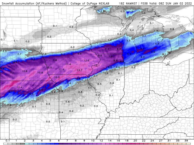
15z RAP north of the 12z HRRR in terms of snow totals. Not sure if I believe that. However, the 12z RGEM gave CR about 5 inches of snow. Toss? Have to wait for the 18z HRRR to see if it stays south or shifts back slightly north.
-
1
-
-
12z GFS seems to be too far north with the snow totals, hasn't budged since 0z. However, it's a bit drier than 6z.
-
12z ICON trended back a bit north in terms of the snow shield, now in line with the rest of the models.
-
 1
1
-
1
-
-
Lowering my call to 4 inches. Hoping I don't bust high.
-
9 minutes ago, Frog Town said:
Noticing the same southerly shift, again. Not gonna lie, I'd love to see this thing shift back south again.
That would leave Cedar Rapids with nothing. Not going to happen.
-
1
-
1
-
New Years Winter Storm
in Lakes/Ohio Valley
Posted
Definitely going to bust low. Possibly they were looking at the high res short term models like the HRRR. Also, there's a pocket of dry air on the DVN radar but it's filling in slowly.