Natester
-
Posts
1,223 -
Joined
-
Last visited
Content Type
Profiles
Blogs
Forums
American Weather
Media Demo
Store
Gallery
Everything posted by Natester
-
0512 PM SNOW 1 S MIDWAY 42.08N 91.71W 01/01/2022 M5.5 INCH LINN IA TRAINED SPOTTER This your report?
-
MCD for southeast Iowa for potential of snows at or over 1 inch an hour (includes Cedar Rapids) SUMMARY...Occasional 1 in/hr snowfall rates possible into the early evening. DISCUSSION...Regional radar shows a broad area of precipitation extending from portions of central/southeast Iowa into northern/central Illinois. Light to moderate snow has been persistent across this region for the past several hours, with localized/brief periods of heavy snow reported at a few stations, in association with broad low-level warm/moist air advection. Earlier, a band of moderate to heavy snow was evident across southwest Iowa and has since translated into parts of central Iowa. This feature is likely in association with mid-level forcing for ascent from a short-wave trough traversing the region and associated mid-level frontogenesis, albeit weakening somewhat. Forecast soundings continue to indicate nearly saturated conditions (e.g., RH values exceeding 80-85%) and lift through a 700-800 m thick dendritic layer across the region. This will continue to promote the development of snow bands and areas of heavy snow with rates approaching 1 in/hr into the early evening hours.
-
Definitely going to bust low. Possibly they were looking at the high res short term models like the HRRR. Also, there's a pocket of dry air on the DVN radar but it's filling in slowly.
-
You know, I would be really surprised if Cedar Rapids got more snow than the Chicago suburbs.
-
About 2.5 inches. The 16z HRRR has only an inch for Cedar Rapids. Both will bust low, especially the HRRR.
-
Radar trends for Cedar Rapids look promising. Light snow here, was moderate for about 15-20 minutes.
-
RAP and HRRR only giving Cedar Rapids 2 to 2.5 inches of snow. EDIT: Spitting flurries here now.
-
I very highly doubt that O'Hare will hit 5 inches of snow let alone go above that. Models only show a few inches for Chicago.
-
Lowering my call to 1 inch of snow. However, I expect to get nothing just like on 11/25/2018. Next! EDIT: Nam 3k jumped back north and gives CR over 6 inches. Not sure if I believe that.
-
Both of the NAMs still bullish on amounts. Slightly amped too.
-
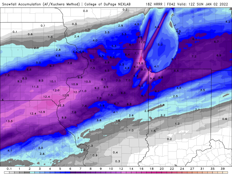
0z HRRR still gives Cedar Rapids a decent amount of snow even if the moderate/heavy snow only lasts a few hours. HRRR shows 4-5 inches for Cedar Rapids.
-
I'm anticipating the northern tier of counties in Iowa under a WSW to be downgraded to an advisory.
-
I'm expecting 0z HRRR to really cut down on the totals, perhaps giving CR only 2-3 inches.
-
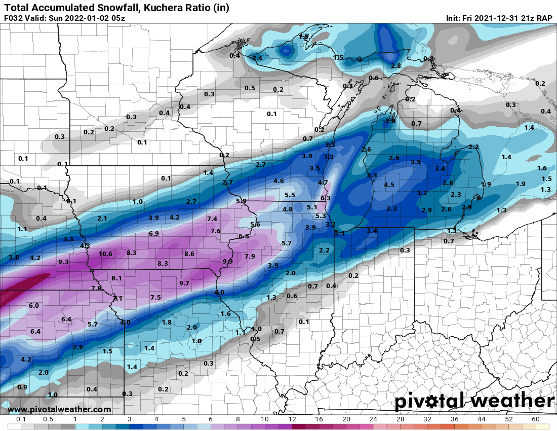
21z RAP snow totals. More down to earth now.

-
18z RGEM and 18z GFS a tick south of 12z.
-
In other news, freezing drizzle is causing alot of travel problems in central and western Iowa. Reports of many crashes. Roads in eastern Iowa are so far wet according to the Iowa 511 road conditions map. The NAM and the HRRR picked up the freezing drizzle potential a couple days ago.
-
Yeah, I forgot about the dry air. Although the southern end of the heavy snow axis is in extreme northern Missouri as shown here.
-
The 18z NAM is an easy toss. Too far north with the heavy snow axis. Doesn't ramp up the system, though.
-
The only good thing about this is the long duration light snows. HRRR predicts 5.5 inches here but I'm skeptical.
-
Lowering my call down to 3.5 inches. EDIT: Snow axis on the HRRR hasn't changed, but it's significantly drier. Also, amounts really cut down for Chicago except for right along the lake. ALEK is going to bust high.
-
Looks reasonable albeit a bit dry. Still within my call of 4 inches although there is a chance i'll bust low.
-
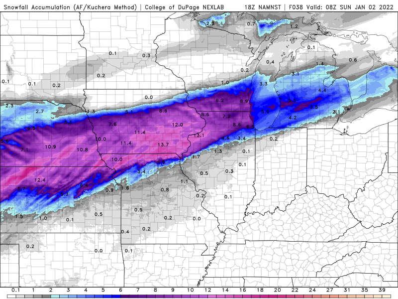
12z euro unchanged in totals (i'm not a subscriber to Pivotal Weather Plus, too expensive). Can someone with a Pivotal Weather Plus subscription post the kuchera method map?
-
15z RAP north of the 12z HRRR in terms of snow totals. Not sure if I believe that. However, the 12z RGEM gave CR about 5 inches of snow. Toss? Have to wait for the 18z HRRR to see if it stays south or shifts back slightly north.
-
12z GFS seems to be too far north with the snow totals, hasn't budged since 0z. However, it's a bit drier than 6z.
-
12z ICON trended back a bit north in terms of the snow shield, now in line with the rest of the models.