

Uncle Nasty
-
Posts
285 -
Joined
-
Last visited
Content Type
Profiles
Blogs
Forums
American Weather
Media Demo
Store
Gallery
Posts posted by Uncle Nasty
-
-
Woke at 3:45. 37 and no snow in Ooltewah. Left for work at 4:45 , light snow, and 33 on weather station. Arrived at Volkswagen, Jeep temp showed 32° and snow has gotten heavier, in the moderate range.Reports of 1-2" in northern Hamilton County in Soddy Daisy


Sent from my SM-S916U using Tapatalk-
 4
4
-
-
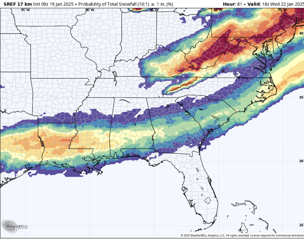
Interesting wording on the detailed forecast from Morristown. The 1st screenshot is a blanket forecast for the Morriatown coverage area, and the 2nd screenshot is Hamilton County specific . They mention possible moderate accumulation here. Hmmm. What are they seeing? Edit to add: local NBC just said a fast mover and posted graphics showing 2.3" for Chattanooga.


Sent from my SM-S916U using Tapatalk -
36 minutes ago, Knoxtron said:
Currently 3.9° with a windchill in the negative teens! Coldest it's been since the December 2022 cold snap
Picked up a little more fine powder overnight for a grabd total of 1.5", roads are super slippery!

That's too cold for my wife. I'm off work today and thought about driving up there. We'll stay put today amd maybe make some chili. South Chatty areas only had a few quick, dry snow showers.
-
2
-
-
7 hours ago, Cheeznado said:
SREF probabilities shifted significantly south. I think I might be lucky to see any snow at all.
A small surprise can happen. At this point, give me 1" of snow to make the roads white and icy, and I'll be happy. I don't want automobile accidents, of course, just a mini version of Atlanta Snowmageddon. I hope you score a decent event. Still time to ignore models and let Mother Nature do her thing!
-
3 hours ago, Wormy2005 said:
My area is under a winter storm watch!! I've never seen snow before hoping it hits here
Good luck! The Tennessee Valley is pulling for you! I hope you get something!
-
3
-
-
We had 3 separate 5 minute flizzards.

At this time, Im hoping for a big enough plume of moisture to sneak NW and manage 1" to cover the roads on Tuesday. If that happens, we'll have white roads and green grass.
-
4
-
-
29 minutes ago, nrgjeff said:
Guess what's happening in Chattanooga. Cloudy, windy, and cold. Nothing more than a few snow grains.
You must live in Ooltewah too.

-
 1
1
-
-
Radar over Lincoln Financial at gametime looks like my Falcons , ragged.
Edit to add: go Philly!
-
1
-
-
1 hour ago, Daniel Boone said:
Been trying to add pictures but keeps saying max size allowed just 969.0 something kb allowed. Used to be. 1.95 MB. Anyone know what to do ?
Try posting from Tapatalk. Thats the only way it will let me post pictures without using a link to a hosting site.
-
1
-
 1
1
-
-
8 minutes ago, goldman75 said:
I’m still holding onto hope here in Myrtle beach
1 minute ago, fig said:Same in Wilmington!
Reading the forecast discussion for both of your areas is very promising. Those guys are the pros. If I were in either one of your locations. I'd feel pretty good about a good snow.
-
3
-
-
Before I fell asleep last night, I was reading an article from a met based in Missouri. He used to be based in Charlotte. I'll look for the link later on my lunch break. He says as suppressed as the midweek storm looks, don't be surprised if that push of Arctic air modifies quite a bit compared to what is depicted currently on models. If that happens, more qpf could make its way as far north as the Kentucky line, and possibly drop anywhere from. 25-.40" of qpf for parts of Tennessee. With a high ratio snow, that would quickly accumulate for several forum members. I'm not wishcasting, just repeating what a met mentioned. A late model shift and I guess anything is possible.
-
2
-
-
4 hours ago, Neals said:
When we get winter storms it reminds me of Toot. He was in our group of friends and we use to ride around in high school in snow weather. He had a website and tracked storms 10 years back before he passed away at a young age. I see guys here that use to linger in there.
I still have Tennessee Weather Spot on my favorites on an older computer. The site doesn't work anymore, but I actually pulled it up last week out of curiosity. The site is now down and It wouldn't let me log in. If I remember correctly, didn't he die young from heart disease? Man, I used to love reading the arguments between Toot and other posters. I sort of remember he lived in Cocke County and playing the mandolin. I never met him in person, I just remember reading his posts over the years.
-
4
-
-
Peachtree City is already mentioning 10 days down the road. The wording seems that they are mentioning it because everyone is already sharing huge storm totals on social media.

Area Forecast Discussion
National Weather Service Peachtree City GA
307 PM EST Sun Jan 12 2025
I feel like I`m having to do this too much for a meteorologist in Georgia, but let`s once again take a moment to discuss the potential for some winter weather middle of next week. Yet again, we are seeing a few of the operational models occasionally spit out a significant winter event for our area, giving some eye popping 10:1 snow maps ripe for slapping up on social media. With signs that we will have yet another significant Arctic front move through the area by the end of the week into early next week, we will certainly be in a set-up that *could*, once again, bring winter weather into the CWA. Cold air will be well into the Gulf, establishing a baroclinic zone along the coast, and there are signs of a shortwave that may be able to tap into that for surface low formation and have a decent connection to the subtropics to pull in some moisture. However, so far, of the 2-3 potential winter setups like this we`ve seen the models spit out this winter season, 1 has panned out. Getting all the ingredients in line at the right time in the right way is always tough here. To emphasize this, looking at ensemble model probabilities across the 12Z guidance for getting >1" of snow, the GEFS shows around 5%, the European ensemble around 10-15%, and the Canadian about 5% only in northern GA. Could it happen? Absolutely. These probabilities are certainly much higher than the typically probability of snow on a given day in the winter in Georgia (
Sent from my SM-S916U using Tapatalk-
4
-
-
39 minutes ago, Knoxtron said:
Those are awesome pics @Uncle Nasty! I love it up here, it's truly a hidden treasure. I find we average 10-12° cooler in winter (other than really cold lows) and around 15° in summer with a never ending breeze. Looks like you will have a front row view of the hangliders too! It's amazing how high above the brow they will get
I have struggled myself finding a good builder in this area, being relatively remote. There's a new high end subdivision near me with 6+ houses under construction (snowy meadows), ill try and get their info and PM you.
Thank you!
-
We drove up to our property yesterday. Someone did a really good job keeping Window Rock Rd. passable. I'm guessing some local individuals helped as well because we saw a smaller, compact tractor with a plow on the front. It had slid off the road on a hill near an embankment. When we left to return to Ooltewah, a flatbed was there about to pull it out. Snow depth was wonderful on the brow property. Depth was roughly 4" where the trees were thickest. Away from the trees in the more open areas, it was compacted down like you said to 6" or so. I forgot my ruler. It was a beautiful winter wonderland! Getting off topic a but, but do you have any local recommendations for a good builder? Here are a few pics we took. Beautiful scenery everywhere. The picture with my wife and the valley below is where we would like to do something. Several deer tracks in the snow all over. It was beautiful. Took a few pics of someone's frozen pond, nice big field near the bluff of someone elses property.We ended up just shy of 7, 2 inches of powder on top of a crunchy ice sheet
Been plowing our main road for the last 6 hours, nearly passable with 4wd. Chains are a must
The SxS and 4 wheelers were out in full force having a blast! Temp on the Jeep from Ooltewah all the way to Soddy was a solid 34°. It never wavered. Top of the mountain it was 25°. Sorry for the pic overload, I just wanted to share.


Sent from my SM-S916U using Tapatalk

-
10
-
1
-
-
1 hour ago, Knoxtron said:
Absolutely pouring small flakes currently, may be the heaviest snowfall so far!
"Older" snow layer from earlier today is well protected by a layer of ice, this is gonna have some staying power!
What was your final total for the storm? I'm sure it was pretty good before it compacted down. If the roads are ok, we are driving up to our property tomorrow and take some snow pics.
-
Ok folks, it's time to start looking around the 19th or 20th for some cold and snow. You're all allowed 2 days off after everyone wraps up their current snow, and then we move on to the next storm!
Southern snows are super hard to predict. With all the knowledgeable people on here, from pros to high thinking amateurs, I'll grade everyone out to a solid "A".
Local tv Mets are usually conservative, as they should be. I will grade our Chattanooga tv Mets out at a solid A-.
nrgJeff gets a solid "A," leaning towards an A+. Great discussions from everyone! Carver, Holston, John, Tellico, and the rest, great job!
Sent from my SM-S916U using Tapatalk-
8
-
-
Ignore the radar. They have had us as snow and 28° for the last 90 minutes. It's a steady, light sleet. My weather station shows 30°, and I'm good with that.
Sent from my SM-S916U using Tapatalk -
I belive we are finished. It was great. This thing overperformed for a short period. Originally, they thought snow would be coming down until 3 or 4 am Saturday. It really got cranking around 8am and pretty much ended at 1:20. A little over 5 hours and we received between 4-5". The sleet has already compacted my board down. It's crunchy and compacted to 3". Im good with it. It's 30°, and if temps can manage to stay below freezing, this will be around for a few days.Warm nose is a beast. I added an edit with a few pictures, because what's a snow without the gas grill snow pic?

Sent from my SM-S916U using Tapatalk


-
8
-
-
11 minutes ago, ShawnEastTN said:
Chattanooga folks what's it doing down your way? Did you switch?
We switched to light sleet about 25 minutes ago. Radar returns shows all snow but that's wrong. Cold air is trying to fight back. We have sleet and some random big cotton balls falling. Huntsville is 34 and rain/ snow. Birmingham is 34 and all rain. I think we are on borrowed time here.
-
2
-
-
Did 15 measurements throughout the yard and neighborhood. Average is between 4-5 inches. Just had a super heavy band come through. I'm hoping we don't switch to a mix. The snow just suddenly slammed on the brakes, and a random bury of cotton balls will fall down. Very sporadic the last couple of minutes. It's pretty much stopped and now we have a light sleet coming down.


Sent from my SM-S916U using Tapatalk-
9
-
-
This was a little while ago before the rates intensified.

Sent from my SM-S916U using Tapatalk-
8
-
1
-
-
2 minutes ago, Knoxtron said:
I live off 111 and Lewis Chapel at 2100 ft Msl. Currently 24 and have about 4 inches, moderate sized flakes and some of the heaviest snow I've ever seen
0 road treatment in Bledsoe county, had a couple neighbors leave around 7am and 0 chance they make it back without walking
Look forward to a fellow weather weenie on the mountain!
Amazing! We will be on Window Rock Rd roughly 1.5-2 miles past Treetoppers. Where the blacktop ends, maybe another 3/4 mile.
-
2
-
-
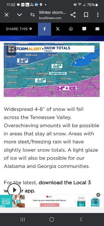
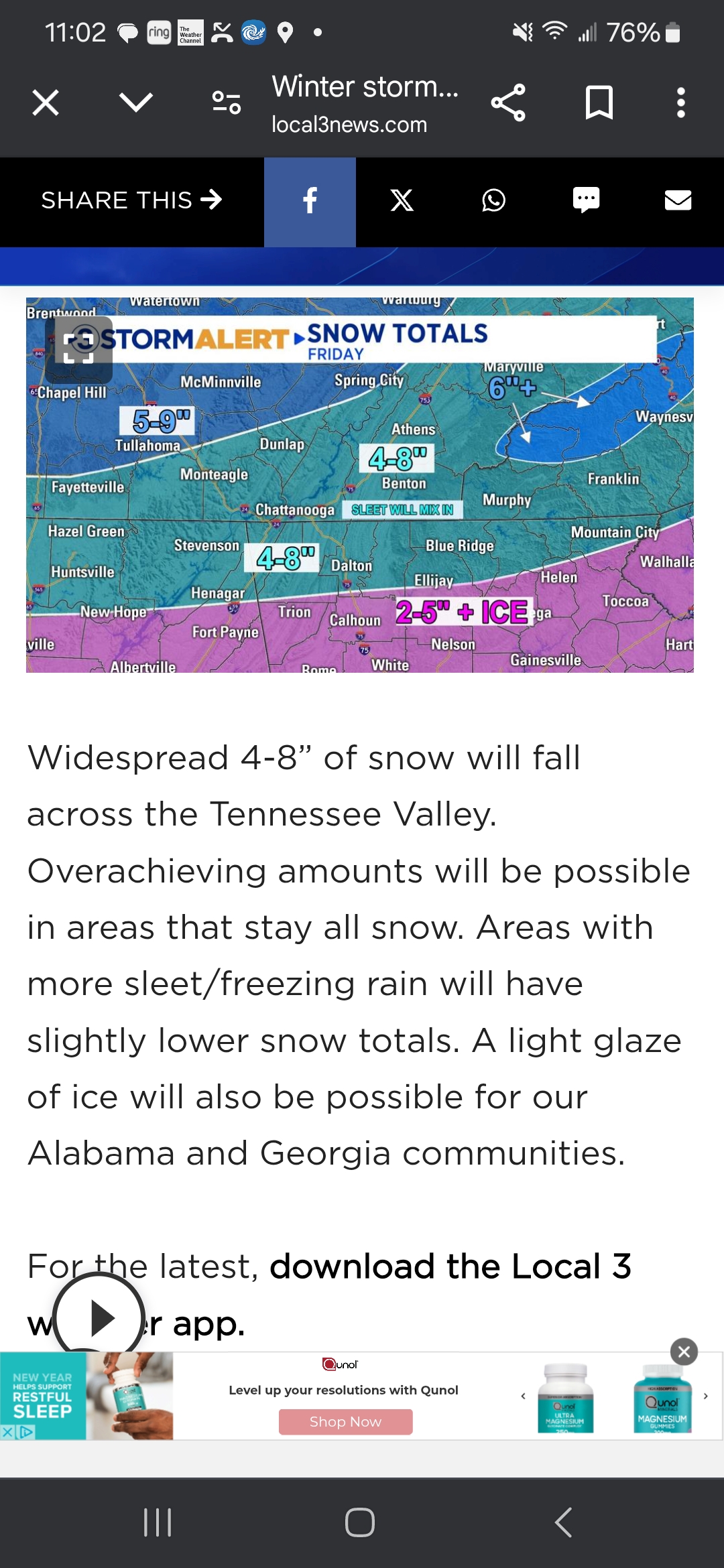
Chattanooga local NBC just updated totals to 4-8"
-
7
-
 2
2
-

2/19-2/20 Miller A Magic?
in Tennessee Valley
Posted
Behind the factory. I wish we could snag 8 hours of this
Sent from my SM-S916U using Tapatalk