

MGorse
-
Posts
1,928 -
Joined
Content Type
Profiles
Blogs
Forums
American Weather
Media Demo
Store
Gallery
Posts posted by MGorse
-
-
8 minutes ago, hazwoper said:
Snow squall warnings up…..radar seems to indicate no big deal.
Radar beam tends to overshoot them at that distance from the radar. Snow squalls are usually lower topped.
-
 2
2
-
 4
4
-
-
Snow Squall Warnings for the Poconos and the Lehigh Valley currently.
-
1
-
-
8 minutes ago, RedSky said:
Sounding like 20:1 ratios in the death band which explains the #'s we saw guidance qpf was fairly accurate.
Yup the massive upward motion in that band that interesected the DGZ coupled with deep saturation resulted in much higher SLRs.
-
3
-
-
53 minutes ago, Kevin Reilly said:
I have a Question?... it almost had an appearance of an elongated norlun trough?
It is completely different. This was via very strong/deep frontogenesis in combination with upper level jet dynamics.
-
3
-
-
Easily half of the 4 inches of snow here has already melted.
-
2
-
-
The consistency of the snow was wetter than I thought it would be. Looks beautiful though covering all the trees.
-
3
-
-
4 inches at my place.
Wow regarding that intense band that occurred. The look of it on radar looked like a fire hose of snow that Buffalo gets off Lake Erie. Insane!
-
3
-
2
-
-
11 minutes ago, Kevin Reilly said:
Yea but from the total QPF it clearly shows that band of subsidence in southern PA southern Chester County right into Delaware Count to the Delaware River and across I mean if that is correct, we will barely crack 2" and we have a Winter Storm Warning. I guess we just cannot know yet where these precious bands are going to set up with 1-2" snowfall rates. I will check back at 2:30 am.
I don’t think it is subsidence, but rather weaker lift outside of the strong lift that is producing the band.
-
3
-
-
2 minutes ago, Birds~69 said:
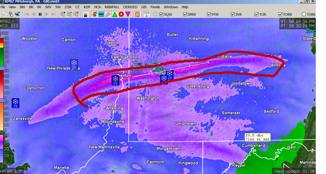
This line around Pitt is cool, no idea what it means, if anything,
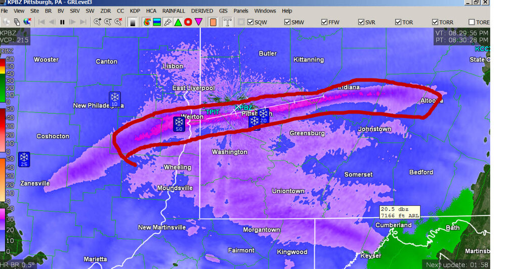
That is a result of tightening 700 mb frontogentic forcing. This is sloped ascent and this narrow band is on the north side of the 700 mb frontogensis. That translates eastward, but let’s see if it remains so narrow like that.
-
5
-
-
Quick look at radar and the HRRR and it looks like the HRRR is not initializing the heavy band of snow in OH and western PA quite right.
-
7
-
-
Just now, Prairie Dog said:
Working tonight Mike? Thanks for posting here
Nope, my shift is wrapping up shortly.
-
2
-
 1
1
-
-
Well, some of you got your upgrade to a Winter Storm Warning.
")
-
2
-
1
-
 5
5
-
-
4 minutes ago, Albedoman said:
At the rate this LP is getting juiced in the latest model runs, 4-6 in from a line from Reading over to Central Montgomery/Bucks County seems likely. Betting WSW will be issued from Norristown south where the 5 In criteria maybe met. If I was Mt Holly , I would issue a winter storm watch for the other areas to the immediate north up to the LV and wait until the 00Z runs come in for the NAM/HRRR to either upgrade to a WSW or downgrade to an advisory. Everyone else a WWA. Confidence is real low for reaching WSW criteria north of Norristown. The best part is that this will be a plowable event for most everyone.
A little late for any winter storm watches to be issued. Advisories have already been issued, and some of those can always be upgraded to a warning if need be.
-
2
-
2
-
-
Impressive storm in more ways than one.
-
7
-
-
29 minutes ago, Kevin Reilly said:
I bet Delaware County is split in half Northern and Western Parts of Delaware County go under a Winter Storm Warning 3-5" and the east side goes Winter Weather Advisory 1-3" that would actually be a good call for around down here and let the chips fall where they may. In the mean time we have light drizzle 42.3f dewpoint up to 39f now.
Delaware County is not split like that.
-
1
-
-
9 minutes ago, Ralph Wiggum said:
People at work in telford blowing this off. Claim it was 50 today it won't stick

Their perspective will change when it is snowing at 1-2 inches per hour and the temperature is 32-34 degrees.
-
3
-
-
4 minutes ago, ChescoWx said:
Last 2 HRRR starting to step back on snow totals especially the further south and east from earlier runs -something to watch!

That is at 13z. Still snowing after that.
-
2
-
-
1 hour ago, anthonyweather said:
I think I read that they are having another update at 6PM
.The main forecast updates are issued around 4 AM/PM.
-
46 minutes ago, anthonyweather said:
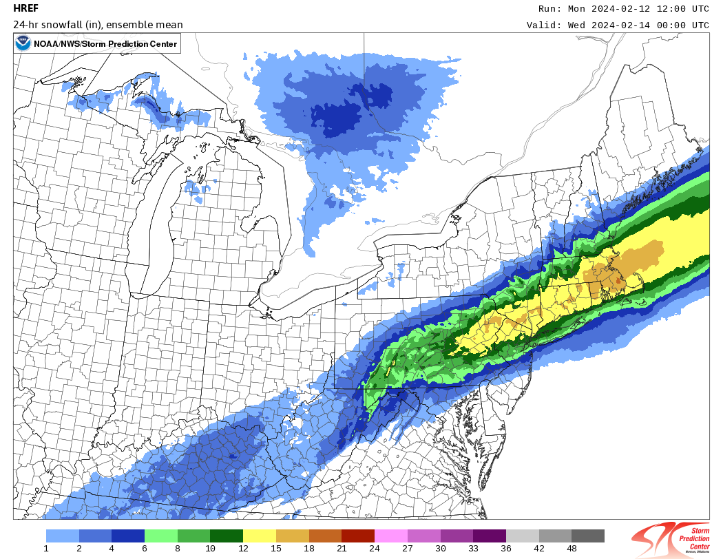
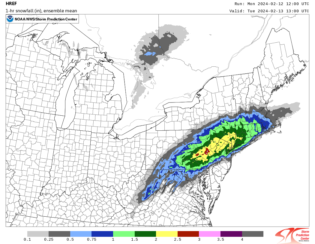
So I know the NWS relies heavily on the HREF. So here is the latest HREF.. Maybe why they arent changing their forecast? Only thing I can think of
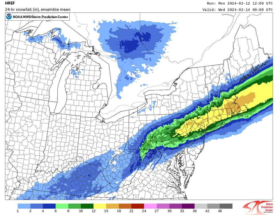

The HREF is looked at but I would not say we rely heavily on it.
-
3
-
-
This is insane! I would literally be pulling my hair out if working today. Did mention over the weekend at work that this storm could be a surprise but was not sure where.
-
3
-
1
-
1
-
-
2 hours ago, Stormman96 said:
I did read it it says if warning level snows arent reached it will be converted so while issue it in first place
Because given the uncertainty the Winter Storm Watch covers a bit larger area.
-
2
-
2
-
-
4 minutes ago, JTA66 said:
Thanks! Like most weenies, my reading comprehension/retention sucks
Yup, I missed that as well.
-
This storm setup has that look though of an area of heavy banding which would be all snow as the column cools. We shall see. I just want to know, how much snow for Philly?
-
1
-
1
-
-
Not saying the GFS is right for the later Monday and Tuesday storm, however it shows some strong lift centered within the snow growth zone with high relative humidity especially from about I-78 northward when it shows all snow. Surface temperatures fall to near freezing so it would be a wetter snow. It looks to be a quick moving storm, but something to watch as potentially stronger dynamics come into play.

The Official Unofficial Overnight February 16/17th Snow/OBS Thread
in Philadelphia Region
Posted
The 700 mb FGEN was insane with this event, thus the crazy hourly snowfall rates and totals in a narrow band. This is from the SPC mesoscale analysis data.