paweather5
-
Posts
405 -
Joined
-
Last visited
Content Type
Profiles
Blogs
Forums
American Weather
Media Demo
Store
Gallery
Everything posted by paweather5
-
Central PA - Winter 2018-19
paweather5 replied to pasnownut's topic in Upstate New York/Pennsylvania
-
Central PA - Winter 2018-19
paweather5 replied to pasnownut's topic in Upstate New York/Pennsylvania
-
Central PA - Winter 2018-19
paweather5 replied to pasnownut's topic in Upstate New York/Pennsylvania
-
Central PA - Winter 2018-19
paweather5 replied to pasnownut's topic in Upstate New York/Pennsylvania
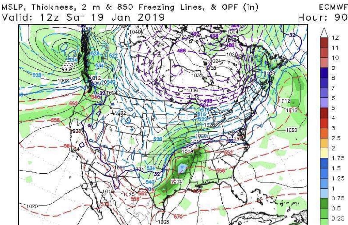
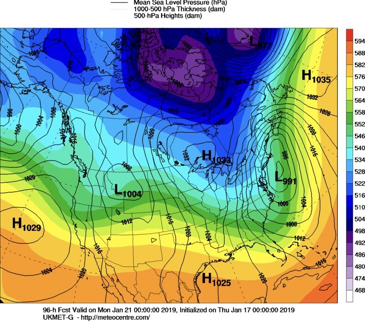
Anyone see the new euro run. Believe it only runs out to hour 90.

-
Central PA - Winter 2018-19
paweather5 replied to pasnownut's topic in Upstate New York/Pennsylvania
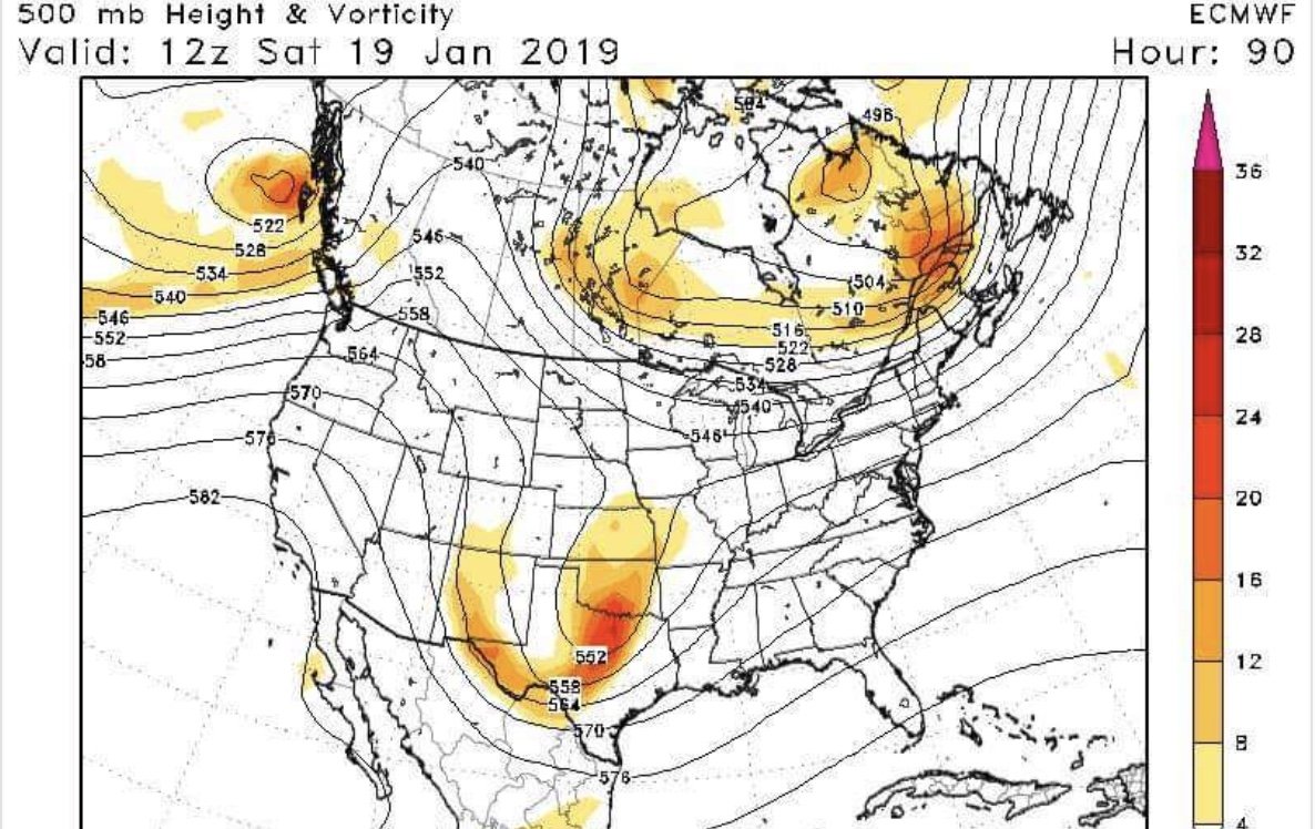
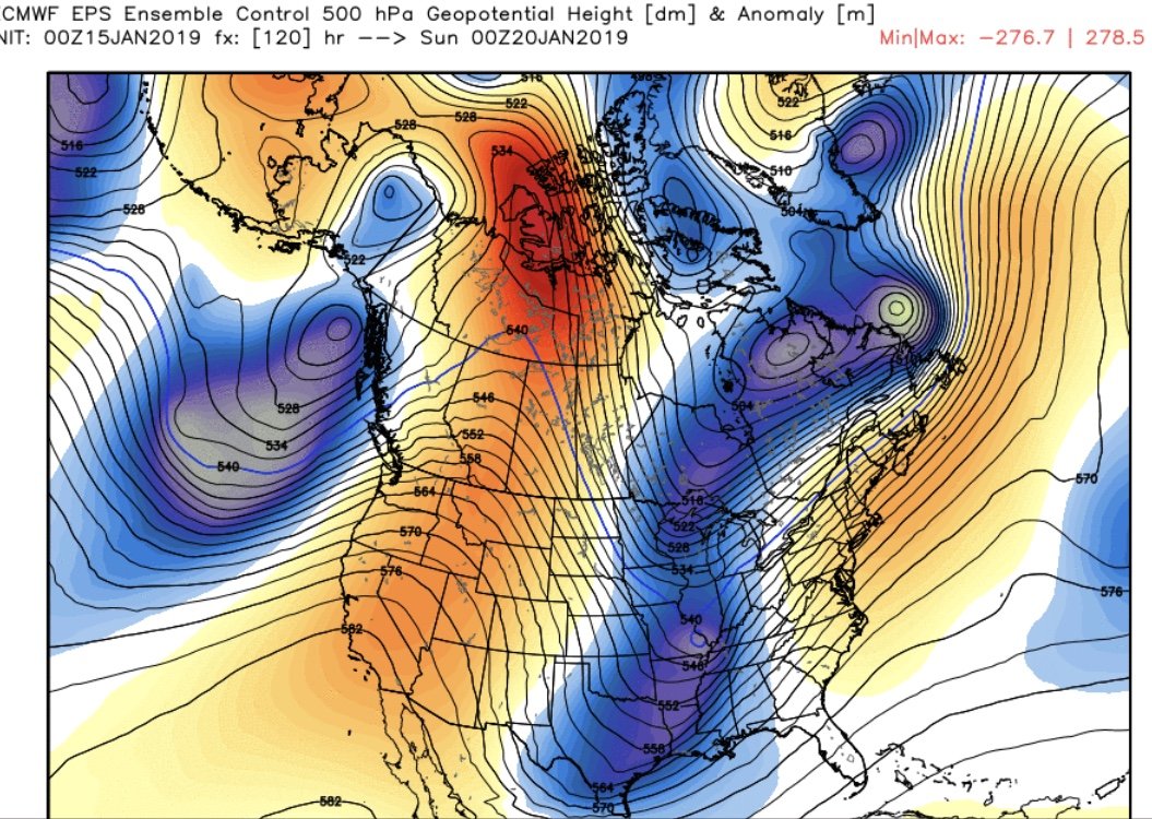
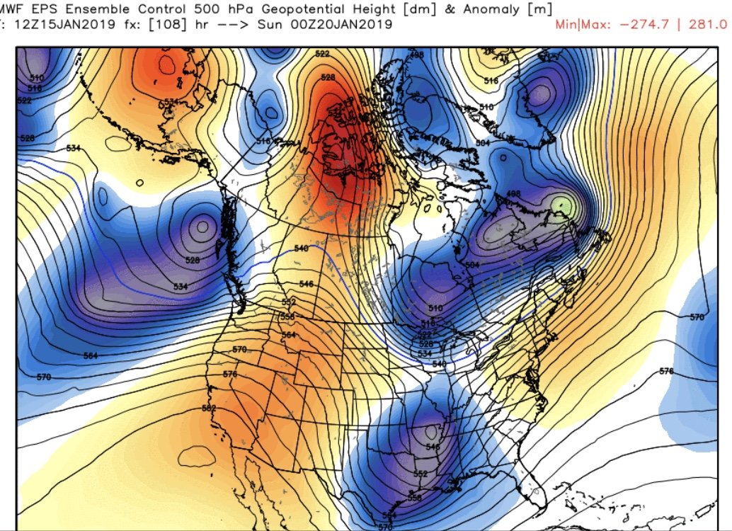
This is what I am trying to say you still have to camps. Southern and northern look at the ensembles. You can see on the GEFS and GEPS you have less interaction with the TPV. The Euro run was actually a huge improvement with less interaction with the TPV. Can the UKMET be leading the way. Could be all for nothing but worth watching.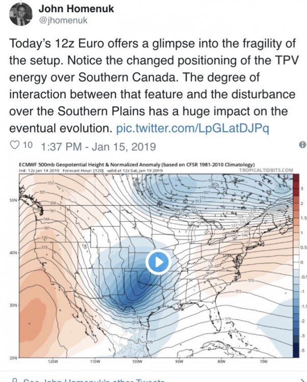
-
Central PA - Winter 2018-19
paweather5 replied to pasnownut's topic in Upstate New York/Pennsylvania
In one run look what the EPS does starts to show separation as well.

-
Central PA - Winter 2018-19
paweather5 replied to pasnownut's topic in Upstate New York/Pennsylvania
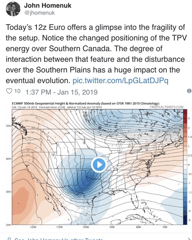
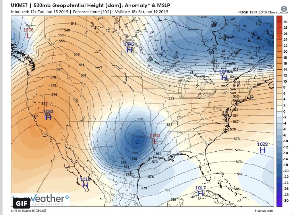
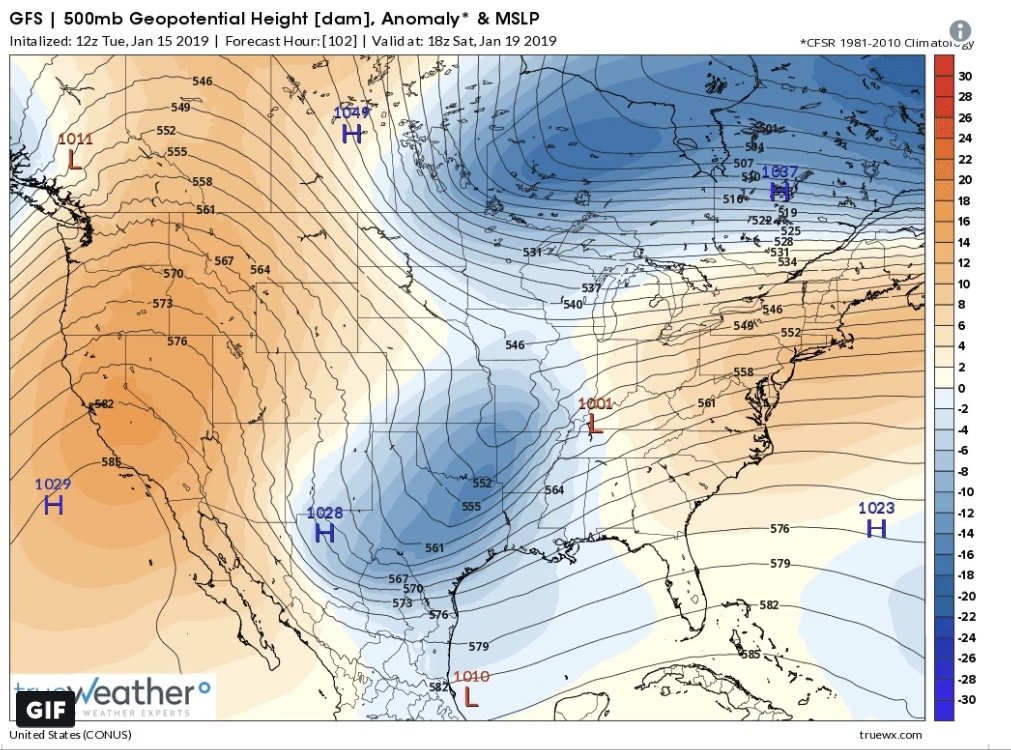
I don’t know if you can write this off yet. The reason Ukmet is south is no phase with the northern stream. Jma and I know the deep thunder model now support it to some extent. Look at the UKMET and GFS.

-
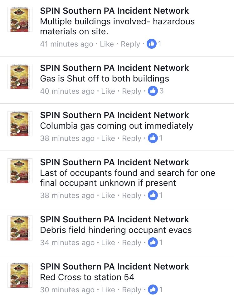
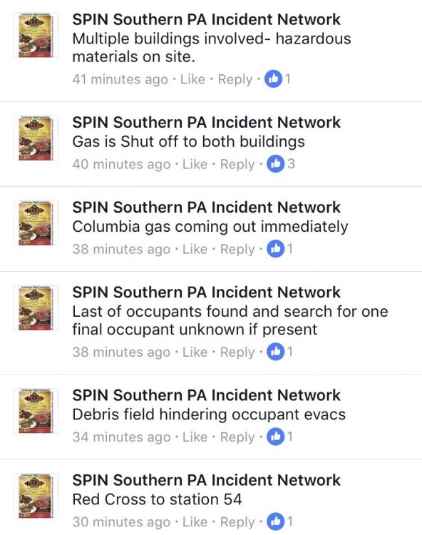
Multiple roofs and structure collaps in southern york. 21:28:56 11-02-18 box: 54-02 STRUCTURE COLLAPSE SOUTH FIRE TG , BARRENS RD N@ PLANK RD , HOPEWELL TWP, cross streets: roof blown off, wires down units: FIRESTA54,E54-3,E45,TK54,EMSSTA54,EMSSTA102-6,A54-2,MICU58 [2128] (112)
-
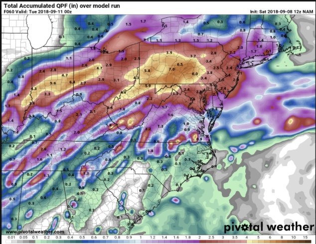
If the nam is correct and Flo does come into the area could be really bad.
-
https://www.google.com/amp/s/articles.pennlive.com/life/2018/06/amanda_st_hilaire_abc27.amp
-
Man look out as that comes north that put down some serious rain. Flooding like crazy again.
-
THE NATIONAL WEATHER SERVICE IN STATE COLLEGE PA HAS ISSUED A * SEVERE THUNDERSTORM WARNING FOR... NORTHWESTERN LANCASTER COUNTY IN SOUTH CENTRAL PENNSYLVANIA... CENTRAL YORK COUNTY IN SOUTH CENTRAL PENNSYLVANIA... SOUTHEASTERN DAUPHIN COUNTY IN SOUTH CENTRAL PENNSYLVANIA... * UNTIL 1115 PM EDT. * AT 1019 PM EDT, A SEVERE THUNDERSTORM WAS LOCATED OVER JACOBUS, MOVING NORTH AT 35 MPH. HAZARD...60 MPH WIND GUSTS. SOURCE...RADAR INDICATED. IMPACT...EXPECT DAMAGE TO ROOFS, SIDING, AND TREES. * THIS SEVERE THUNDERSTORM WILL BE NEAR... DALLASTOWN, RED LION AND YOE AROUND 1020 PM EDT. YORK, SPRY, WEIGELSTOWN, VALLEY VIEW, EAST YORK, STONYBROOK-WILSHIRE, TYLER RUN-QUEENS GATE, NORTH YORK, GRANTLEY AND WEST YORK AROUND 1030 PM EDT. BAINBRIDGE, MOUNT WOLF, MANCHESTER, HALLAM, MARIETTA, MAYTOWN AND WRIGHTSVILLE AROUND 1040 PM EDT. ELIZABETHTOWN, MIDDLETOWN, MOUNT JOY, RHEEMS AND ROYALTON AROUND 1050 PM EDT. OTHER LOCATIONS IMPACTED BY THIS SEVERE THUNDERSTORM INCLUDE YORK HAVEN, SEVEN VALLEYS, THREE MILE ISLAND, WINTERSTOWN, LOGANVILLE, NEW SALEM, GOLDSBORO, NEWBERRYTOWN, PENN STATE HARRISBURG AND HARRISBURG INTERNATIONAL AIRPORT. THIS INCLUDES THE FOLLOWING INTERSTATES... THE PENNSYLVANIA TURNPIKE FROM MILE MARKERS 245 TO 258. INTERSTATE 83 BETWEEN MILE MARKERS 5 AND 34, AND NEAR MILE MARKER 46. INTERSTATE 283 FROM MILE MARKERS 0 TO 2. PRECAUTIONARY/PREPAREDNESS ACTIONS... FOR YOUR PROTECTION MOVE TO AN INTERIOR ROOM ON THE LOWEST FLOOR OF A BUILDING. TORRENTIAL RAINFALL IS OCCURRING WITH THIS STORM, AND MAY LEAD TO FLASH FLOODING. DO NOT DRIVE YOUR VEHICLE THROUGH FLOODED ROADWAYS. && HAIL...<.75IN WIND...60MPH