

yoda
-
Posts
59,574 -
Joined
Content Type
Profiles
Blogs
Forums
American Weather
Media Demo
Store
Gallery
Posts posted by yoda
-
-
Hurricane Maria Discussion Number  12
NWS National Hurricane Center Miami FL       AL152017
1100 PM AST Mon Sep 18 2017

The Air Force Hurricane Hunters were able to fly a single pass
from northwest to southeast through the eye of Maria just prior to
0000 UTC.  The aircraft found a peak SFMR wind of 139 kt in the
northwest eyewall, i.e. category 5 intensity.  Raw objective
T-numbers from UW/CIMSS reached as high as T7.3 just before the
center moved over land.  Based on these data, the initial wind speed
was increased to 140 kt on the earlier special advisory, and that
intensity is maintained for this advisory, although some slight
weakening may have occurred as the small core of the hurricane
passed over Dominica.  Since the center has moved over land, the
aircraft has not been able to make a second pass through the eye.
The aircraft will be in the storm a few more hours and should be
able to provide additional center fixes once the eye moves west of
Dominica.

Maria is forecast to remain within an environment of low wind shear
and over warm water during the next couple of days.  Given these
favorable atmospheric and oceanic conditions, Maria is expected to
remain a Category 4 or 5 hurricane when it approaches the Virgin
Islands and Puerto Rico, however some fluctuations in intensity are
possible due during the next 24 to 36 h due to eyewall cycles.  Land
interaction and a slight increase in shear are likely to cause some
gradual weakening after Maria moves over the southwestern Atlantic
in 3 to 4 days.

Maria is moving west-northwestward or 300/8 kt.  A weak ridge
located over the western Atlantic is expected to steer the
hurricane west-northwestward through 48 hours, and on this track the
center of Maria is forecast to pass near or over the Virgin Islands
and Puerto Rico on Wednesday.  After that time, the western portion
of the ridge is forecast to weaken, which should allow Maria to turn
northwestward, then north-northwestward by day 5.  The track
guidance is in good agreement and little change was required to the
NHC track forecast through 72 hours.  At days 4 and 5, the global
model envelope has shifted slightly eastward and the NHC forecast
was adjusted accordingly to be in better agreement with the HFIP
correct consensus and ECMWF model.


KEY MESSAGES:

1. Maria will affect portions of the Leeward Islands and the British
and U.S. Virgin Islands as an extremely dangerous major hurricane
during the next couple of days, and hurricane warnings are in effect
for many of these islands.

2. Maria is likely to affect Puerto Rico as an extremely dangerous
major hurricane, and a hurricane warning is in effect for that
island.  Preparations to protect life and property should be rushed
to completion.

3. The potential for a life-threatening storm surge, accompanied by
large and destructive waves, has increased for the Leeward Islands,
the Virgin Islands, and Puerto Rico.

4. Life-threatening flash floods and mudslides from heavy rainfall
are expected across the Leeward Islands, including Puerto Rico and
the U.S. and British Virgin Islands.


FORECAST POSITIONS AND MAX WINDS

INIT  19/0300Z 15.5N  61.4W  140 KT 160 MPH
 12H  19/1200Z 16.1N  62.6W  140 KT 160 MPH
 24H  20/0000Z 17.0N  64.0W  140 KT 160 MPH
 36H  20/1200Z 17.9N  65.4W  135 KT 155 MPH
 48H  21/0000Z 18.7N  66.9W  125 KT 145 MPH
 72H  22/0000Z 20.5N  69.6W  120 KT 140 MPH
 96H  23/0000Z 22.8N  71.5W  110 KT 125 MPH
120H  24/0000Z 25.5N  72.5W  100 KT 115 MPH

$$
Forecaster Brown
-
BULLETIN
Hurricane Maria Advisory Number  12
NWS National Hurricane Center Miami FL       AL152017
1100 PM AST Mon Sep 18 2017

...EYE OF CATEGORY 5 HURRICANE MARIA MOVING OVER DOMINICA...


SUMMARY OF 1100 PM AST...0300 UTC...INFORMATION
-----------------------------------------------
LOCATION...15.5N 61.4W
ABOUT 0 MI...0 KM NW OF DOMINICA
ABOUT 270 MI...435 KM SE OF ST. CROIX
MAXIMUM SUSTAINED WINDS...160 MPH...260 KM/H
PRESENT MOVEMENT...WNW OR 300 DEGREES AT 9 MPH...15 KM/H
MINIMUM CENTRAL PRESSURE...924 MB...27.29 INCHES
-
Hurricane Maria Tropical Cyclone Update
NWS National Hurricane Center Miami FL       AL152017
935 PM AST Mon Sep 18 2017

...MARIA MAKES LANDFALL ON DOMINICA AS A CATEGORY 5 HURRICANE...

Radar data from Martinique and Air Force Reserve Hurricane Hunter
aircraft reports indicate that Maria made landfall on Dominica
around 915 PM AST (0115 UTC) with estimated winds of 160 MPH
(260 KM/H).

The next update will be the 1100 PM AST (0300 UTC) complete advisory
package.

SUMMARY OF 935 PM AST...0135 UTC...INFORMATION
---------------------------------------------------
LOCATION...15.3N 61.3W
ABOUT 0 MI...0 KM SE OF DOMINICA
MAXIMUM SUSTAINED WINDS...160 MPH...260 KM/H
PRESENT MOVEMENT...WNW OR 295 DEGREES AT 9 MPH...15 KM/H
MINIMUM CENTRAL PRESSURE...924 MB...27.29 INCHES

$$
Forecaster Brown
-
 1
1
-
-
Not sure if where this goes... so if not here please tell me where
-
1
-
-
BULLETIN - EAS ACTIVATION REQUESTED
Flash Flood Warning
National Weather Service Kansas City/Pleasant Hill MO
1204 AM CDT TUE AUG 22 2017

...FLASH FLOOD EMERGENCY FOR THE KANSAS CITY METRO...

The National Weather Service in Pleasant Hill has issued a

* Flash Flood Warning for...
  Wyandotte County in northeastern Kansas...
  Leavenworth County in northeastern Kansas...
  Johnson County in east central Kansas...
  Clay County in west central Missouri...
  Platte County in west central Missouri...
  Jackson County in west central Missouri...

* Until 800 AM CDT Tuesday

* At 1201 AM CDT, Doppler radar indicated thunderstorms with very
  heavy rain across the warned area. Flash flooding is already
  occurring, and will continue to worsen through the early morning
  hours. Water rescues are ongoing throughout the Kansas City area,
  and creeks and streams are rising rapidly.

This is a FLASH FLOOD EMERGENCY for the Kansas City Metropolitan
Area. This is a PARTICULARLY DANGEROUS SITUATION. SEEK HIGHER GROUND
NOW!

* Some locations that will experience flooding include...
  Kansas City, Overland Park, Olathe, Independence, Lee`s Summit,
  Shawnee, Blue Springs, Lenexa, Leavenworth, Leawood, Raytown,
  Liberty, Gladstone, Grandview, Prairie Village, Gardner, Grain
  Valley, Lansing, Excelsior Springs and Merriam.

This includes the following highways...
 Interstate 70 in Missouri between mile markers 0 and 29.
 Interstate 70 in Kansas between mile markers 410 and 423.
 Interstate 35 in Missouri between mile markers 0 and 32.
 Interstate 35 in Kansas between mile markers 202 and 235.
 Interstate 29 between mile markers 0 and 25.
 Interstate 635 between mile markers 0 and 12.
 Interstate 470 between mile markers 0 and 16.
 Interstate 435 between mile markers 0 and 83.
 Kansas Turnpike between mile markers 206 and 226.

PRECAUTIONARY/PREPAREDNESS ACTIONS...

Move to higher ground now. This is an extremely dangerous and
life-threatening situation. Do not attempt to travel unless you are
fleeing an area subject to flooding or under an evacuation order.

Be especially cautious at night when it is harder to recognize the
dangers of flooding.
-
Ouch time
BULLETIN - EAS ACTIVATION REQUESTED Severe Thunderstorm Warning National Weather Service Dodge City KS 248 PM CDT THU AUG 10 2017 The National Weather Service in Dodge City has issued a * Severe Thunderstorm Warning for... Northeastern Trego County in west central Kansas... Western Ellis County in central Kansas... * Until 345 PM CDT * At 248 PM CDT, a severe thunderstorm was located 4 miles southwest of Ogallah, or 7 miles southeast of Wakeeney, moving east at 40 mph. This is a very dangerous storm. HAZARD...Softball size hail and 70 mph wind gusts. SOURCE...Radar indicated. IMPACT...People and animals outdoors will be severely injured. Expect shattered windows, extensive damage to roofs, siding, and vehicles. * Locations impacted include... Wakeeney, Ellis, Ogallah, Trego Center and Riga. -
12z GFS trop at 384 would have the SNE cane chasing

-
10
16
09
13
00
96
I think that makes sense... was out of town for 96... anything before that I don't remember/too young to remember
-
Thanks all of you for putting this stuff together
-
-
-
-
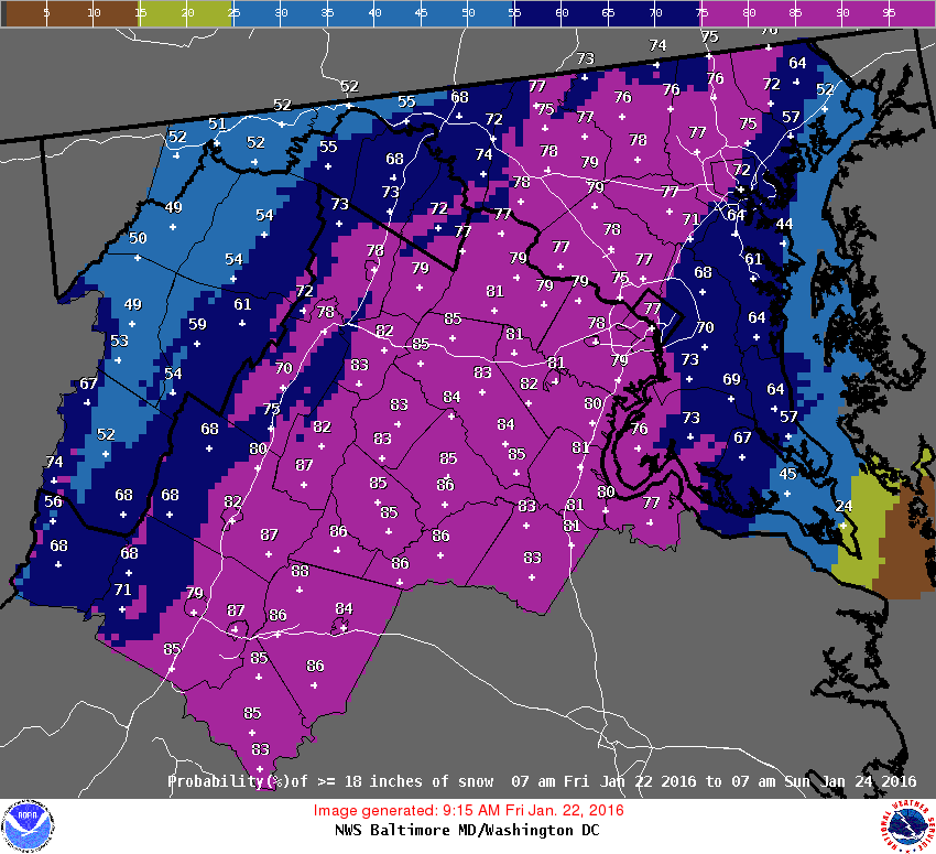
SPECIAL WEATHER STATEMENT
NATIONAL WEATHER SERVICE WAKEFIELD VA
1032 AM EST SUN JAN 17 2016
VAZ048-060>062-064>069-079>083-087>090-509>520-171800-
FLUVANNA-PRINCE EDWARD-CUMBERLAND-GOOCHLAND-CAROLINE-MECKLENBURG-
LUNENBURG-NOTTOWAY-AMELIA-POWHATAN-BRUNSWICK-DINWIDDIE-
PRINCE GEORGE-CHARLES CITY-NEW KENT-GREENSVILLE-SUSSEX-SURRY-
JAMES CITY-WESTERN LOUISA-EASTERN LOUISA-WESTERN HANOVER-
EASTERN HANOVER-WESTERN CHESTERFIELD-EASTERN CHESTERFIELD-
WESTERN HENRICO-EASTERN HENRICO-WESTERN KING WILLIAM-
EASTERN KING WILLIAM-WESTERN KING AND QUEEN-
EASTERN KING AND QUEEN-
INCLUDING THE CITIES OF...FARMVILLE...GOOCHLAND...SOUTH HILL...
CREWE...LAWRENCEVILLE...PETERSBURG...HOPEWELL...EMPORIA...
WAKEFIELD...WILLIAMSBURG...LOUISA...MINERAL...ASHLAND...
MECHANICSVILLE...MIDLOTHIAN...BON AIR...CHESTERFIELD...CHESTER...
COLONIAL HEIGHTS...RICHMOND...SANDSTON...AYLETT...KING WILLIAM...
WEST POINT...KING AND QUEEN COURTHOUSE
1032 AM EST SUN JAN 17 2016
...SNOW AFFECTING CENTRAL AND SOUTH CENTRAL VIRGINIA...
SNOW WILL CONTINUE ACROSS CENTRAL AND SOUTH CENTRAL VIRGINIA
THROUGH EARLY AFTERNOON. SNOW WILL REDUCE VISIBILITY TO ONE MILE
OR LESS. ACCUMULATION WILL AVERAGE AROUND ONE INCH AND ACCUMULATE
MAINLY ON THE GRASS AND ELEVATED SURFACES.
MOTORISTS SHOULD BE ALERT FOR REDUCED VISIBILITY DUE TO AREAS OF
SNOW. DRIVE AT REDUCED SPEEDS AND USE LOW BEAM HEADLIGHTS.
-
From Broyles... Day 4 OTLK:
DAY 4-8 CONVECTIVE OUTLOOK NWS STORM PREDICTION CENTER NORMAN OK 0342 AM CST SUN NOV 08 2015 VALID 111200Z - 161200Z ...DISCUSSION... THE MEDIUM RANGE MODELS BEGIN THE DAY 4 TO 8 PERIOD WITH AN IMPRESSIVE UPPER-LEVEL SYSTEM OVER THE SRN AND CNTRL PLAINS. STRONG TO POTENTIALLY SEVERE THUNDERSTORMS MAY BE ONGOING AT THE START OF THE PERIOD IN THE CNTRL PLAINS NEAR THE EXIT REGION OF A POWERFUL 85 TO 100 KT MID-LEVEL JET. THIS JET MAX IS FORECAST TO MOVE ENEWD INTO THE MID MS VALLEY DURING THE DAY ON WEDNESDAY/DAY 4 AS A COLD FRONT ADVANCES QUICKLY EWD ACROSS THE REGION. THUNDERSTORM COVERAGE IS EXPECTED TO EXPAND FROM THE LOWER MO VALLEY SWD INTO THE OZARKS EARLY IN THE DAY AS SFC DEWPOINTS INCREASE INTO THE 60S F ALONG THE FRONT. THIS COMBINED WITH ENHANCED LARGE-SCALE ASCENT ASSOCIATED WITH THE FAST MOVING UPPER-LEVEL SYSTEM AND VERY STRONG DEEP-LAYER SHEAR SHOULD BE FAVORABLE FOR SUPERCELLS WITH WIND DAMAGE AND SOME TORNADOES. AN ENHANCED SEVERE THREAT MAY DEVELOP ACROSS PARTS OF THE MID MS VALLEY WEDNESDAY AFTERNOON AND EVENING WITH THE SEVERE THREAT EVENTUALLY REACHING THE OH AND TN VALLEYS.

-
Anything before 2003 I don't remember much of, so I am basing my ratings after that storm. In '96, I was stuck in FL for my grandparents' 50th wedding aniversary, so I missed that storm completely... it was hell to get a flight back into DCA from JAX...
Jan 2000 -- All I really remember was listening to my weather radio and hoping beyond hope Bob Ryan was wrong (that we would get grazed by the SLP at best, one inch at most) and hearing my weather radio go off ~10PM and WSWarnings being issued for 4-8 inches for us... then 6-12 later that night and so on. I remember running downstairs to my dad and telling him -- he didn't believe me until he saw the warnings himself

2009-10 season as a whole was the best... I remember being on the computer alot where I work and not getting much done during the December storm and the February storms since I was tracking the storms so much... luckily most of the admin knows I am a "weather nerd" so they let me do some model watching as long as I did some work
If I had to pick one, probably the Feb 5-6 storm first
-
I hardly even remember PD2. I'd suspect it's because I was working (bartender) and drunk pretty much the whole time because barely any other restaurants were open for a few days afterwards.
I got stuck in Wilkes-Barre, PA during '96. We got about 20" up there, while my hometown in Jersey got 33".
December 18-19 was an awesome storm, but its 22" was almost dwarfed by the 27" from Feb 5-6. I only got 8-9" from Feb 10, but the morning blizzard band was pretty sick.
No doubt, though, that Dec 18-19 was in my top 5 all time. Easy.
96 we were stuck in FL (JAX) for a family vacation and it was tough getting back in... we got one of the last flights back from RDU to DCA. 09-10 was awesome for both storms, both the Dec and Feb ones.
-
Jesus... you had me scared for a minute...
-
I remember being at work and getting absolutely nothing done... staff members were coming up to me and asking me about the weather all day... I was supposed to help write up a lesson plan for the next week (right before Christmas break) but I never did it cause I knew that we weren't going to be in school.
Remembering how the NAM was giving the LWX region 2.5" liquid and we all thought that was outrageously high... I'll think of more
-
did we have a small blurp a little while ago? PC screen Jiggled for a few seconds. Actually felt it clearly.
welcome to 30 mins ago

-
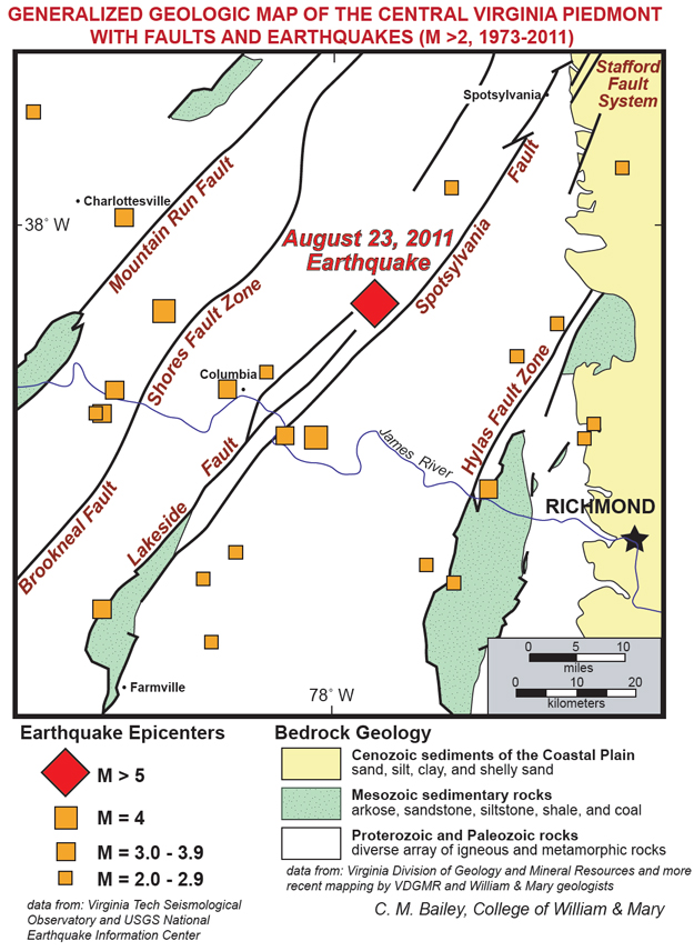
Any of you geologists have a link to what fault it was? There are stress faults all over the place, but clearly this little guy helped relieve a lot of tension.
-
felt it here... my cup full of water sloshed a lil bit
-
The director of the USGS said it's possible the 5.8 was not the main event but the foreshock.

-
2.8 aftershock at 2:45 pm per CWG on FB
-
Depth was 1 km or .6 miles... woah der


Hurricane Maria
in Tropical Headquarters
Posted