

yoda
-
Posts
59,675 -
Joined
Content Type
Profiles
Blogs
Forums
American Weather
Media Demo
Store
Gallery
Posts posted by yoda
-
-
I love some Miller A rainstorms... especially when the GFS makes 1000 mile movements with N/S stuff every run
-
 1
1
-
-
Just now, DDweatherman said:
Maybe I looked at the wrong map, if so I apologize for bad info. I am mobile so I haven’t loaded up maps.
seeing the snow axis bullseyeing NYC I assumed it was south a bit.
It LOOKS better because now there is a bunch more snow in PA on 00z then there was at 12z. No change here lol
-
Just now, WinterWxLuvr said:
My local forecast Yoda. You see Monday night?
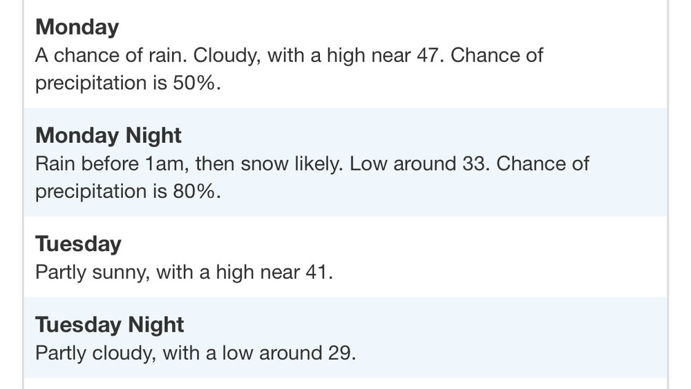
I see white rain with no accumulation. Thats what this system is for us
-
Just now, DDweatherman said:
 Someone post the 12z to 0z comparison
lol.. you arent using the right map. Use Kuchera. No way its 10:1
-
Just now, DDweatherman said:
Yoda, it’s not snowing in Springfield most likely either way. The GGEM was the furthest south it’s been yet again
Its not going to be snowing up there either lol.
Correct, and the snow maps showed nothing in the LWX CWA
-
1
-
-
-
1 minute ago, WinterWxLuvr said:
Lol, my god that’s the best it’s looked
And it STILL declines to place any snow besides a coating south of the M/D line
-
2 minutes ago, DDweatherman said:
Or the rest of the 0z models maybe?
CMC is a HELL NO
-
Just now, stormtracker said:
Cut off of snow is literally the M/D line...lol
Pretty much time to wave goodbye to this threat
-
Warmer and more north SLP at 81
-
That escalated quickly
BULLETIN - EAS ACTIVATION REQUESTED Tornado Warning National Weather Service Milwaukee/Sullivan WI 550 PM CST Thu Feb 8 2024 The National Weather Service in Milwaukee/Sullivan has issued a * Tornado Warning for... Northern Rock County in south central Wisconsin... Southeastern Dane County in south central Wisconsin... Southwestern Jefferson County in southeastern Wisconsin... * Until 630 PM CST. * At 549 PM CST, a confirmed large and extremely dangerous tornado was located near Evansville, moving northeast at 45 mph. This is a PARTICULARLY DANGEROUS SITUATION. TAKE COVER NOW! HAZARD...Damaging tornado. SOURCE...Weather spotters confirmed tornado. IMPACT...You are in a life-threatening situation. Flying debris may be deadly to those caught without shelter. Mobile homes will be destroyed. Considerable damage to homes, businesses, and vehicles is likely and complete destruction is possible. * Locations impacted include... Whitewater, Stoughton, Fort Atkinson, Jefferson, Lake Mills, Milton, Edgerton, Evansville, Johnson Creek, Cambridge, Lake Ripley, Lake Koshkonong, Fulton, Albion, Hebron, Utica, Rockdale, Busseyville, Cooksville, and Indianford. PRECAUTIONARY/PREPAREDNESS ACTIONS... To repeat, a large, extremely dangerous and potentially deadly tornado is on the ground. To protect your life, TAKE COVER NOW! Move to a basement or an interior room on the lowest floor of a sturdy building. Avoid windows. If you are outdoors, in a mobile home, or in a vehicle, move to the closest substantial shelter and protect yourself from flying debris. && LAT...LON 4272 8927 4287 8936 4305 8902 4309 8874 4285 8868 4284 8877 4283 8878 TIME...MOT...LOC 2349Z 237DEG 37KT 4279 8922 TORNADO...OBSERVED TORNADO DAMAGE THREAT...CONSIDERABLE MAX HAIL SIZE...1.25 IN -
Severe Weather Statement National Weather Service Milwaukee/Sullivan WI 535 PM CST Thu Feb 8 2024 WIC025-045-105-090015- /O.CON.KMKX.TO.W.0003.000000T0000Z-240209T0015Z/ Green WI-Rock WI-Dane WI- 535 PM CST Thu Feb 8 2024 ...A TORNADO WARNING REMAINS IN EFFECT UNTIL 615 PM CST FOR NORTHEASTERN GREEN...NORTHWESTERN ROCK AND SOUTHEASTERN DANE COUNTIES... At 534 PM CST, a confirmed tornado was located near Albany, or near Evansville, moving northeast at 40 mph. HAZARD...Damaging tornado and half dollar size hail. SOURCE...Weather spotters confirmed tornado. IMPACT...Flying debris will be dangerous to those caught without shelter. Mobile homes will be damaged or destroyed. Damage to roofs, windows, and vehicles will occur. Tree damage is likely. Locations impacted include... Stoughton, Oregon, Evansville, Brooklyn, Albany, Magnolia, Dayton, Attica, and Cooksville. PRECAUTIONARY/PREPAREDNESS ACTIONS... To repeat, a tornado is on the ground. TAKE COVER NOW! Move to a basement or an interior room on the lowest floor of a sturdy building. Avoid windows. If you are outdoors, in a mobile home, or in a vehicle, move to the closest substantial shelter and protect yourself from flying debris. && LAT...LON 4264 8953 4277 8958 4293 8941 4293 8910 4272 8918 4265 8936 TIME...MOT...LOC 2334Z 233DEG 36KT 4275 8942 TORNADO...OBSERVED MAX HAIL SIZE...1.25 IN -
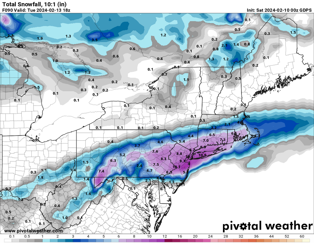
Presidents Day threat takes a little while to get going... but that qpf field... woof
-
Just now, stormtracker said:
Better for norther folks accumulation wise. Def drier tho. I lost like 8”. Shut up RR
Thanks Ji
-
Ripping snow at 117 at DCA and north
-
6
-
 2
2
-
-
Over ORF at 114
-
1
-
-
995 in SW WV at 111
-
29 minutes ago, Shad said:
thoughts on hour 240 of Euro?
Probably going to be wrong, so hopefully I will be corrected if so, but I don't think we like what h5 showed at 240

Ridge is not where we want it out west, in fact, it seems to be on top of the system. There's a strong s/w crashing into CA, which is lowering the heights and pushing our ridge into the Plains instead of the Rockies where we want it.
-
1
-
-
4 minutes ago, psuhoffman said:
The gfs is slowly getting to the blocking the other guidance has. So it’s shifting this weird solution south. In the end once the gfs adjusts to reality I don’t thing this evolution can work for us. The boundary is going to be much further south than the gfs thinks because it’s not resolving the block correctly. In the end the only way I see the PD threat working is if a NS wave can dig in behind the stj wave and phase/buckle the flow and bomb it up the coast. There are a couple NS waves that could do it. Euro control was very close last night but missed the phase by a hair.
Wasn't there a storm recently like this? Like in the past 10 years or so? Maybe 15? Not the insane amounts... but it crushed RAH to around RIC... EZF got a few inches... but once you got near DCA it was green grass. I'm not sure if it was because of blocking... but I distinctly remember traveling up i95 and having to stop overnight in NC because the roads were so bad
-
1
-
-
Just now, MN Transplant said:
How you gonna ban someone for posting a blank map?
I always thought you were a great met... hopefully you'll be back under a new name soon
")
-
 1
1
-
-
Looks like around 55% of the 12z GEFS members gave 2" or more snow at DCA
-
2
-
-
-
Just now, Deck Pic said:
That's a snowstorm...Does pivotal have access to the whole column on the euro or is some of this extrapolated between layers
What do you mean? The column is on the left side
-
4 minutes ago, stormtracker said:
Is 168 snow?
This is what the PW sounding at DCA has

-
 1
1
-


Mid/Late February will be rocking. (This year we mean it!) February long range discussion.
in Mid Atlantic
Posted
00z CMC is a snowstorm for EZF south for PD