
CASH_COOP
-
Posts
410 -
Joined
-
Last visited
About CASH_COOP

Recent Profile Visitors


-

Central PA Winter 25/26 Discussion and Obs
CASH_COOP replied to MAG5035's topic in Upstate New York/Pennsylvania
Mark this one down as a disappointment for me. 6.2” snow 1.1” sleet so far. -
Central PA Winter 25/26 Discussion and Obs
CASH_COOP replied to MAG5035's topic in Upstate New York/Pennsylvania
Hanging on to all snow right now just measured 6 inches 9F -
Central PA Winter 25/26 Discussion and Obs
CASH_COOP replied to MAG5035's topic in Upstate New York/Pennsylvania
I love tables as a reference to check. I need a bigger one lol. That pic was from a while ago. Just measured 3.3”. Good luck. Just got off phone with nws, they said areas around Lewistown are the most likely winners with 15-20” -
Central PA Winter 25/26 Discussion and Obs
CASH_COOP replied to MAG5035's topic in Upstate New York/Pennsylvania
7a obs light snow 10f 3.3”M 0.29” liquid -
Central PA Winter 25/26 Discussion and Obs
CASH_COOP replied to MAG5035's topic in Upstate New York/Pennsylvania
you can see the heavier bands forming to the south on sterling radar. going to be dumping, im at 10f. -
Central PA Winter 25/26 Discussion and Obs
CASH_COOP replied to MAG5035's topic in Upstate New York/Pennsylvania
Everybody enjoy the storm! We were way overdue.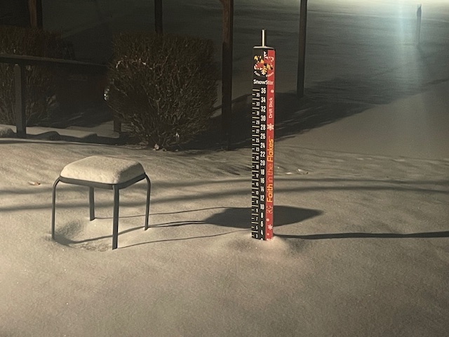
-
Central PA Winter 25/26 Discussion and Obs
CASH_COOP replied to MAG5035's topic in Upstate New York/Pennsylvania
def wetter. if that verifies there will be a 20"+ report in sc pa, right above mixing line. -
Central PA Winter 25/26 Discussion and Obs
CASH_COOP replied to MAG5035's topic in Upstate New York/Pennsylvania
can you post qpf total. looks juiced up -
Central PA Winter 25/26 Discussion and Obs
CASH_COOP replied to MAG5035's topic in Upstate New York/Pennsylvania
I agree, 8 to 10 inches before mixing and 1 or 2 inches of sleet on top is my thinking for me -
Central PA Winter 25/26 Discussion and Obs
CASH_COOP replied to MAG5035's topic in Upstate New York/Pennsylvania
I think a good strategy today would be to find areas upstream that have a similar forecast as ours and see which way they trend snow vs sleet -
Central PA Winter 25/26 Discussion and Obs
CASH_COOP replied to MAG5035's topic in Upstate New York/Pennsylvania
Very exciting times finally something to post about this winter. I’m looking forward to meso range and start seeing the high-end potential. -
Central PA Winter 25/26 Discussion and Obs
CASH_COOP replied to MAG5035's topic in Upstate New York/Pennsylvania
You might have to dust off the big daddy hat -
Central PA Winter 25/26 Discussion and Obs
CASH_COOP replied to MAG5035's topic in Upstate New York/Pennsylvania
I always look forward to your post. -
Central PA Winter 25/26 Discussion and Obs
CASH_COOP replied to MAG5035's topic in Upstate New York/Pennsylvania
Impressive for the airport. I had 5 coldest so far dis season -
Central PA Winter 25/26 Discussion and Obs
CASH_COOP replied to MAG5035's topic in Upstate New York/Pennsylvania
M3.8”

