

SnowNiner
-
Posts
1,905 -
Joined
-
Last visited
Content Type
Profiles
Blogs
Forums
American Weather
Media Demo
Store
Gallery
Posts posted by SnowNiner
-
-
15 minutes ago, griteater said:
This is going to work out pretty well (for once), though the vision I had for the storm threat (#3) was more of a west to east, moderate strength storm as opposed to a full-on nor'easter.
Going forward, both Anthony Masiello (HM) and Isotherm are honking for January (these are 2 of the best out there for long range discussion):
Anthony - https://twitter.com/antmasiello/status/1338312081926447117?s=20
Isotherm - https://www.americanwx.com/bb/topic/54035-my-winter-outlook-2020-21/?do=findComment&comment=5732631
Anthony is expecting an MJO orbit through phases 7-8-1-2 late Dec thru January - https://twitter.com/antmasiello/status/1337383148112449538?s=20
Here is what MJO Phase 8 looks like in early January on average - suppressed tropical convection in the Maritime Continent (orange/red/white colors), ridge over Alaska / Western Canada / Greenland, trough east of the Rockies:

Excellent job Grit! Calls were very accurate looking back. Hope you and the rest are just as accurate with late December going into January. Feels like it may actually be real this time.
-
 1
1
-
 1
1
-
-
2 hours ago, griteater said:
Gotcha, yeah, true it is difficult to get the variables to all come together for a long duration freezing rain event from a big gulf low (like Dec 2002)
Agreed. You really need everything to line up right for a true problematic ice storm. December 2002 was the last one I remember that actually caused real problems IMBY. This week will likely not be anything close. Not enough qpf, not cold enough. All models seem to show eventually Wednesday everything turning to plain rain, washing away the glaze.
2002 was something else though. Just pouring rain all night in the 20's. Dead silence in the morning, everything covered with ice, trees bent in half.
-
1
-
-
53 minutes ago, JoshM said:
Going to be a very close call south of I-40, I would pay attention to High Res NAM. IMO, it handles the CAD better


Those dew points are just not very cold. I can't get past that. Hope the 3K tomorrow will see it a bit colder tomorrow.
-
40 minutes ago, griteater said:
The -AO/-NAO are helping here, but for our region, ideally those reds over Greenland (positive anomalies) would be farther S/SW
Agreed, I'd love to have the high pressure in NY and not Canada. Beggers/choosers whatnot, but I'm happy to have some tracking in December. If we keep the -AO/-NAO regime into January I think we score eventually.
-
11 minutes ago, griteater said:
Sounds about right, but we'll see how this trends going forward.
In terms of the modeling, the CMC is good at getting early hints at CAD, but it's typically too cold. Euro is probably a little too warm. The high res models will be on the colder side I'm sure. 50/50 low needs to escape to the NE slower to see this get colder
You would think this decent -NAO we finally have on our side right now would work some magic and keep the 50/50 more in place. Perhaps it can do work, we'll see.
-
8 minutes ago, burrel2 said:
One negative about this event is there’s no extremely dry surface air to start. A lot of times the cad over performs due to under modeling of how dry the preceding air mass is. That won’t be much of a factor for this storm.
I agree. Dew points for the Carolinas in the 20s does not seem like we cool that much. That plus the EPS backing off on the strength of the 50/50 makes me think this is a classic north of I40 situation for anything noteworthy.
-
6 minutes ago, griteater said:
It really is....everything just has to fall right when it's like that. Things like, snow hard to get temps to crash and get that first layer down, snow when the sun is down, etc.
For me it's all about surface temps. If you can't wet bulb down to 32 (preferably 30), it's just really hard to get good accumulating snow. My biggest take away this storm so far is I want my high pressure in the NE. Good strong CAD signal. Cold air in place first. Waiting for rain/rates to get snow is a losing battle 9 times out of 10.
-
1
-
-
2 minutes ago, griteater said:
The teleconnections don't look good for this storm let me tell ya


It is amazing we're talking about snow at all considering the overall pattern. Just think what we can do next year with a raging -AO and super pumped +PNA!
-
3
-
-
11 minutes ago, David Johnson said:
Up’d the totals some from GSP2-3 in Iredell county. Score! lol.
I'll take it. Let me see some flakes fly for a while, make a few snowballs, and let's get on with spring.
-
4 minutes ago, griteater said:
Raleigh NWS has the chance of precipitation tomorrow and tomorrow night in Greensboro at 50%. That's kind of astounding.
They have Greensboro and Winston-Salem both with 1 inch of snow in the forecast. I'd take the over on that one all day long
Agreed. When there's ANY kind of winter storm in the Carolinas where precip gets to VA, Greensboro and Winston Salem get the lion's share. They'll struggle least with temps as usual.
-
1
-
-
23 minutes ago, Cold Rain said:
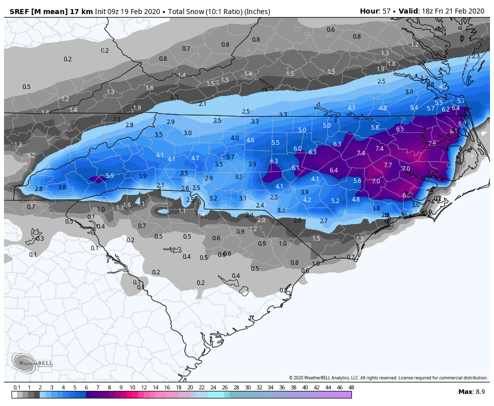
The transition to snow almost always takes longer than expected. I don't feel too optimistic on 10" totals around here, even in the sweet spot, wherever that ends up being. But I do think it will snow for a lot of people. The most likely scenario in my mind is a similar distribution of precip type, along the lines of what the NAM is showing, but with much lower totals. South of Raleigh will probably fight mixing issues for a good portion of the storm. I'd guess a 1-3" gradient across Wake and higher amounts of maybe 3-5" toward the VA border. The northern and central coastal plain will probably be the best area to see 4-6". Going to be hard to beat that unless a really intense band sets up and doesn't move.
No doubt things could overperform. But they usually underperform, in spite of what the models are showing at this lead.
If the HRRR doesn't come around and if the NAM keeps creeping north with the warm layer, and if other models like the GFS continue to warm, then we know that we're tracking toward a lower end event. This isn't an ideal setup, but it may be just good enough. Often, just good enough is the same as not very good, so we'll see how this one unfolds. We need good rates, and hopefully they will occur.
This is your storm CR. If anybody's going to pull off a winter storm in NC it's you guys out east. You may mix with some sleet but I think eastern sections score even with the warm nose. Moisture hangs out with you guys a lot longer than it will for us out west. That'll give time for the cold to get here IMO. Bask in your coastal!
-
1
-
-
Just now, It's Always Sunny said:
Yeah it's definitely concerning. It's a storm where dynamics will have the final say. If it snows hard enough low level temps can easily wet bulb to allow accumulations. Could be a situation where the roadways are fine but grassy surfaces get a couple inches depending on where you are.
Thanks, yeah that's been exactly my fear all along. GFS was in and out of there quick too. It's NAM or nothing at this point for mby.
-
9 minutes ago, griteater said:
HREF Precip Type
If we could start and finish the storm with snow that would be great. It keeps the rain/snow line nice and south of clt (well lake norman, then quickly goes south).
-
That's not good. It's going to be warmer I'd expect...
-
Just now, Blue_Ridge_Escarpment said:

Wow, that looks great. It removes the lull in the central piedmont, hope it's right.
-
Just now, BullCityWx said:
I guess my question to myself, in that situation, is why would I trust the GFS with thermals?
Yeah, well because all the professional forecasters seem to be along with GSP. They're discounting the nam.
-
35 minutes ago, Amos83 said:
I like where we are sitting @Wow, I think we will be just far enough north to not have too much mixing issues, just need the precip
I'm worried about surface temps. Per the GFS, we're warm at the surface even though the column is cold and it's snowing. Nam is a bit colder but seems to be discounted by....like everybody. If we're sitting at 36 or so we'll lose alot of accumulation and sticking to the roads is doubtful IMO. I don't see the rates being hard enough to cool us down to freezing. Evidently no other met does either looking at the accumulation numbers forecasted. Everybody is honking the "on elevated surfaces" jargon. Sigh. Hoping things tick colder today.
Remember when we were worried about qpf? Nope, it's always temps.

-
4 minutes ago, Wow said:
Yup... overblown more than likely. Thinking a general 1-3" with 3-6" maximums east part of the state. Marginal temps.. wet snow
Surface temps are my pet peeve, listening to the snow melt and run down the gutters as it falls.
With the nam moving North and North with the warm nose this may not be a very impactful storm for clt.
-
1
-
-
5 minutes ago, griteater said:
Agree. It comes down to precip rates and how shallow the near surface warm layer is. In this case the GFS and NAM yield good rates and the warm layer is very shallow (in this area) so I’d expect to see surface temps move 2-3 degrees lower than modeled. But look above, as warm nosing aloft is a separate problem. The Euro doesn’t have the precip rates
I'm completely fine with sleet if we're solidly below freezing. I'd just like a strong winter storm event. I'd suspect that's why many mets are going so low impact event with this is 1. Hugging the euro and 2. seeing above freezing surface temps.
It would be nice if we didn't have to worry about temps one time wouldn't it?! Only a 1043+ high in just the right spot....
-
2
-
-
One thing I'm watching though, assuming the qpf is significant in mby, is the surface temps. The last GFS run although improved, still has surface temps around 34 degrees during the event (per soundings). Yes accumulation can happen at that temp but we'll lose accumulation because of it. I'd really like the nam to be more right not only because of qpf but its slightly colder. I'd greatly like to be below freezing during peak moisture.
-
 2
2
-
-
10 minutes ago, griteater said:
The Euro is 0 for 5 in SE Winter Storm Model Battles


Really? I would not have expected that thanks. My understanding is that the snow event from last weekend in GA was also poorly modeled by the euro, but well done by the nam. See I write that, but I'm having such a hard time believing it. I want to weenie out but my skeptical mind just won't let me!

-
1
-
-
18 minutes ago, griteater said:
I like the idea of this meeting in the middle with the model runs today and tomorrow. The NAM is too wet and the Euro is too dry.
That would make sense and give most of NC a decent snow event. However the euro and gfs are on the warmer side of things even if they get wetter. Nam this morning has crept the rain line up to clt. Getting dangerously close to our back yards even on the coldest model. Hoping today and tomorrow things trend colder and that high does work. Like you said yesterday, higher heights for this storm may fight the cold push a bit. Never like seeing higher heights in the SE when trying to get cold in.
-
1
-
-
14 minutes ago, griteater said:
This run of the NAM pretty much matches the track and precip footprint of the GFS/Euro, but it's simply much heavier with the precip on the north side owning to potentially resolving the higher resolution dynamics at play (heavy frontogenesis). Maybe the NAM is too heavy with the precip and maybe the globals are too light
Yeah, that seems to be the big question...which is out to lunch, the nam or the globals? Man I want to believe but the long range nam versus the euro/ukmet. My brain says that's not even a fight.
-
most important NAM run in forever. HUGE! lol. Hoping it holds serve.
-
 1
1
-
Mid to Long Term Discussion 2020
in Southeastern States
Posted
Thirded.
Thankfully with the strat taking a beating it "seems" like the blocking regime will hang around. I read too that a December -AO regime usually lasts deep into winter. With everyone expecting +PNA first of January timeframe we could be right on the edge of a really great pattern first week of the year. Without it though anything we see until then will likely not be cold enough IMO. All eyes on January.