

SnowNiner
-
Posts
1,906 -
Joined
-
Last visited
Content Type
Profiles
Blogs
Forums
American Weather
Media Demo
Store
Gallery
Posts posted by SnowNiner
-
-
2 minutes ago, Amos83 said:
The fact that this is an ensemble mean is absurd. As much as I want to get deliriously excited about this I think we need to remember that we will for sure be dealing with WAA at some point, no way we will get such a juiced up storm and not have it. WAA is very hard to forecast and many times it comes it stronger than anticipated.
Having said that it is beautiful to see these runs continue over and over
We need Kuechera ensemble mean snow maps.
-
58 minutes ago, griteater said:
30 inches of clown snow for snowniner


 Lol, yep, I'll take my 30 inches and love it!...until the next Euro run! I saw the low further east off the coast and I knew it was going to be a better run than last night.

-
13 minutes ago, griteater said:
I think though that we are headed in the direction of more of a Miller B or Miller B Hybrid as HkyWx calls it....where that was straight Miller A...so, I would expect much more mixed precip compared to that one, IMO
I'm surprised that even with a strong stj storm with confluence and some blocking we still get a Miller b. I dont know how in the world to get a miller a anymore.
-
I've seen 2 noticeable trends on the EPS. First, the 50/50 low has trended stronger and SW, which I think is good. That's why our high pressure is modeled great and our confluence is keeping the low suppressed in the gulf nicely. However it seems like once the storm hits the coast, the northern stream energy is phasing and tugging it closer to the coast on the last several runs. Therefore I still like the threat of a good first thump of snow/sleet, but once the storm is to our south, things may pull north and WAA will take over.
That's right now. Hopefully that 50/50 will get keep trending stronger and the northern energy will trend slower to keep this thing south.
-
 1
1
-
-
2 minutes ago, griteater said:
18z EPS Mean compared to the 12z EPS Mean was a bit more amplified with the wave...a little north with the sfc and 850mb low tracks. It was a little warmer from Bama thru TN again as the low tracks across the gulf coast while maintain the relative cold east of the Apps...so it continues to increase its recognition of the damming high to the north. The closed off 850mb low on the mean tracks from Birmingham, AL to Cape Hatteras. That track is very good for the N NC Mtns into SW VA, but problematic for warm nosing aloft from the upstate into parts of central NC
Thanks grit, hopefully that corrects south tonight. It seems to be going back and forth, bit north, bit south.
-
3 minutes ago, Poimen said:
I'm not sure if this really matches the model, but I believe this is based on the Kuchera method, FWIW:
Yeah I noticed the model output doesn't seem to reflect the snowfall output, even the Kuchera map. I don't know why. I like the pretty maps though....even in a "bad" run I'm getting nice clown maps.
-
2
-
-
As long as we keep having these awesome ensemble tracks that keep creeping colder and more suppressed, I won't worry about op runs until Thursday.
Other than UK and Euro. I want them in my camp continually and right now. That goes without saying right?
-
1 minute ago, BIG FROSTY said:

Lol, what in the world is that? feedback issues? Squiggly wiggly...
-
 2
2
-
 1
1
-
-
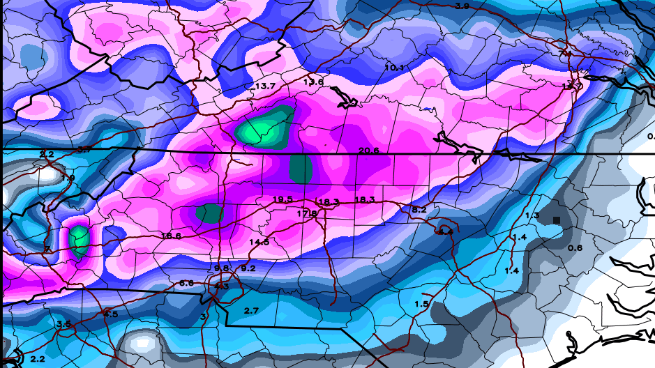
1 hour ago, griteater said:
12z EPS Clown....similar largescale footprint as previous run, but higher totals (more consistency I would assume)

Wait, what? Is that a 12-15 inch mean on the EPS ensembles? Trying to work here people, how did this happen? lol.
I don't think I've ever seen that kind of thing. Beautiful.
-
1
-
-
7 minutes ago, griteater said:
IMO, the biggest thing to watch for the upstate to central NC crowd is how firmly the confluence pattern holds and is reinforced over the Northeast prior to the storms arrival. I think we'll pretty much be able to count on the wave trekking west to east and holding its strength
Agreed, the ensembles seem rock steady on rolling this thing east along the panhandle and off the coast. I hope the FV3 idea of the inland tug is out to lunch. Temps, confluence and CAD seem to be the question mark still. What on the 500 maps do we look for better/worse confluence?
Thank you Grit for the excellent play by play on this storm by the way...
-
 1
1
-
-
4 minutes ago, Queencitywx said:
Yes. Unless they start changing then no reason to panic yet.
Are the means cold? I thought they were pretty marginal, from 850 means that I could see.
-
24 minutes ago, Rankin5150 said:
I feel NWS-GSP worded this spot on:

.LONG TERM /THURSDAY NIGHT THROUGH MONDAY/...
As of 230 PM Monday: No major changes to the overall forecast from
the 12z guidance. If anything, they continue to trend a little
slower/delayed on the onset of precip, and also a little heavier in
QPF. The 12z ECMWF has come in more northerly/inland with the sfc
low track, and results in warmer thicknesses across the FA thru the
event. This allows a stronger warm nose, and perhaps, more of a
mixed bag of p-types, versus more ra/sn that previous runs
suggested. I opted to blend a little 12z ECMWF into the partial
thickness p-type nomogram tool for this forecast. Still get a lot of
snow in the mountains and the I-40 corridor with this solution, but
if the new ECMWF trend holds, these values will likely be a lot
lower, due to the sleet/frza mixing in. With all that said, it still
looks like a significant winter storm on tap for most of the
mountains and adjacent foothills in NC, while the Piedmont south of
I-40 is highly uncertain. Temps will start out below normal Friday,
as a reinforcing cold front pushes thru. Then classic cold air
damming sets up Friday night thru Sunday, as a strong sfc high
builds in across the Ohio Valley to the Mid-Atlantic. The heaviest
precip looks to be mainly Saturday night into early Sunday, but that
time may change slightly as we get closer to the event. Temps will
be tricky with the CAD. I stuck close to WPC, but these may be too
warm within the heart of the CAD wedge.
At this long lead, I wonder why the NWS doesn't lean more heavily on ensembles. They seem to base their forecast on guidance from operational models in their discussion.
-
1 minute ago, jjwxman said:
12z EPS: You really can't ask for much more than this at this stage in the game. Roll on!

Man if we can't get a warning criteria snow in the NC piedmont/Upstate out of that sweet look in December, I will never expect snow again in December. Geez. I don't know how I could draw it any better, other than a stronger high. We suck if we can't snow with that.
-
1
-
-
Boo, Dr No does it again. Can't beat a EURO/UK combo. Temps just don't want to play ball in early December. Maybe we can reset and get a similar setup in January for the win....
-
Not terrible, but not the cold run we wanted. Also the low is a bit more north than we'd like. I don't know. UK and Euro on the warmer side doesn't make me overly optimistic today. On to tomorrow.

-
1
-
-
this looks pretty good to me...need that high though to keep moving east with the low and dig in.

-
Huge Euro run incoming.
Can't have FV3/GFS be the only colder more suppressed model.
-
1
-
-
3 minutes ago, griteater said:
Just looked...you are correct QC at hr120, but at hr144 the 0 deg at 850 is on the NC/VA line....so, it surges well north...good for VA, not for south of there
FV3 on its own then with the colder solution of the storm throughout. Hopefully the EURO will join to add weight. I'd really like the UKMET to trend colder there...as well.
-
1
-
-
5 minutes ago, BretWheatley said:
Sweet Jesus.
Ok, even I can't weenie out that much. I can't even with that. CLT would bet counting snow in feet, not inches. lol. Gonna have that save that one though for fun!
-
1
-
-
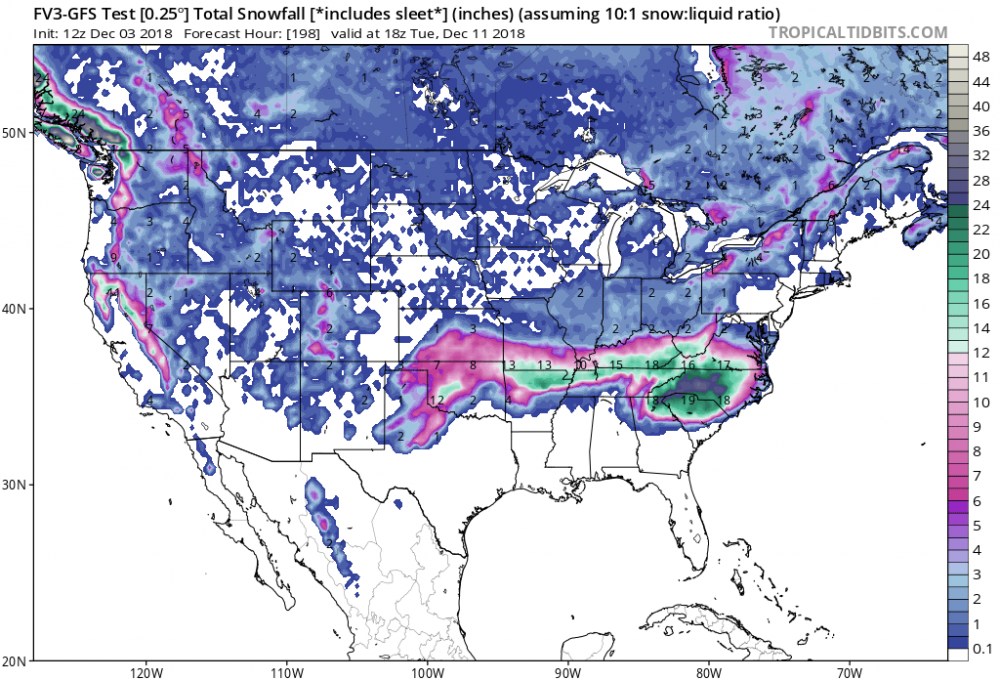
2 minutes ago, Wow said:
FV3 is a monster. Plenty of cold air. Looks like all snow on a line at and north from GSP to CLT to RDU
What's the key in getting that high to pop in the NE? Some modeling is showing only the midwest high, and some like the EURO and FV3 pop the high in the perfect placement. What synoptically needs to happen for that to occur?

-
4 minutes ago, griteater said:
12z GEFS Mean took a baby step south like the Op
Hopefully it ticked colder and lower dew points as well.
-
5 minutes ago, DopplerWx said:
soundings for clt aren't good verbatim. a lot of sleet and frz rain with plain cold rain to start.
Good track, but not cold enough. I want to see the the 850s south of Rock Hill at least.

-
7 minutes ago, griteater said:
For the central and southern areas of the forum, I'd want to see that confluence area created by the southern stream connecting to the Northeast trough to be solid, well-timed, and not retreat north too early...and I'd want the southern wave to make a clean sweep, unencumbered west to east and slide right off the southeast/mid-atlantic coast...and the farther south that west to east trek the better. Go take a look at the 06z FV3 GVS - it nailed it
Thanks! Yeah, saw the FV3, which was a cold, cold run with lots of snow for everybody. NWS also favored the 0Z Euro, which was colder than the EPS so we've got that. Hopefully we can trend back to a more suppressed Miller A track slider. I need the afternoon runs, like right now.
-
2
-
-
14 minutes ago, griteater said:
Looking at the last few runs of the EPS Mean (including this morning's 06z run), there has been a subtle, though noteworthy, north trend with the system and temperatures. At 500mb, the main changes I see are that the amplitude of our southern wave has increased and the blocking confluence region ahead of the storm in the critical area of Ohio/Maryland/PA has climbed north a touch. To me, the target area for heaviest snow at the moment would be SW VA into Central VA, with the extent of wintry precip to the south of there dependent on the strength of the damming high and extent of the cold air source. Right now, the EPS mean is showing dewpoints in the teens in Virginia on Saturday as the storm approaches. For the hardcore mixed precip events in central NC down into the SC upstate and into NE GA, we typically see dewpoints in the single digits in Virginia. Now, that's a surface plot on an ensemble mean 5 days away, but nevertheless, you'd want to see a colder trend there for more mixed wintry precip to the south. In terms of precip, it does indeed look to be a heavy event as others have mentioned for the areas that take a flush hit by the storm given the solid southern stream wave and gulf intake.
Yeah, we need to see this trend colder for sure. 850s shown below won't cut it. What feature do we need to look for to get this colder in upcoming afternoon runs?
I heard we lost the Ukie too? Haven't seen specifics. Sounds like bad trends overnight.

-
1
-

December 8-10, 2018 Winter Storm
in Southeastern States
Posted
Wow, they poo poo'd the whole thing, didn't they? Even for the Triad. Cold rain trend for the Triad? I'm lost on that one.