

Derek30
-
Posts
223 -
Joined
-
Last visited
About Derek30

-
Central/Southern Plains Severe Weather Palooza (4/29 - 05/05)
Derek30 replied to Powerball's topic in Central/Western States
00z HRRR paints an ominous scenario tomorrow with numerous discrete supercells prior to upscale growth into a large bow. 3km NAM, on the other hand, has a lot of early convection in the risk area which muddies things. -
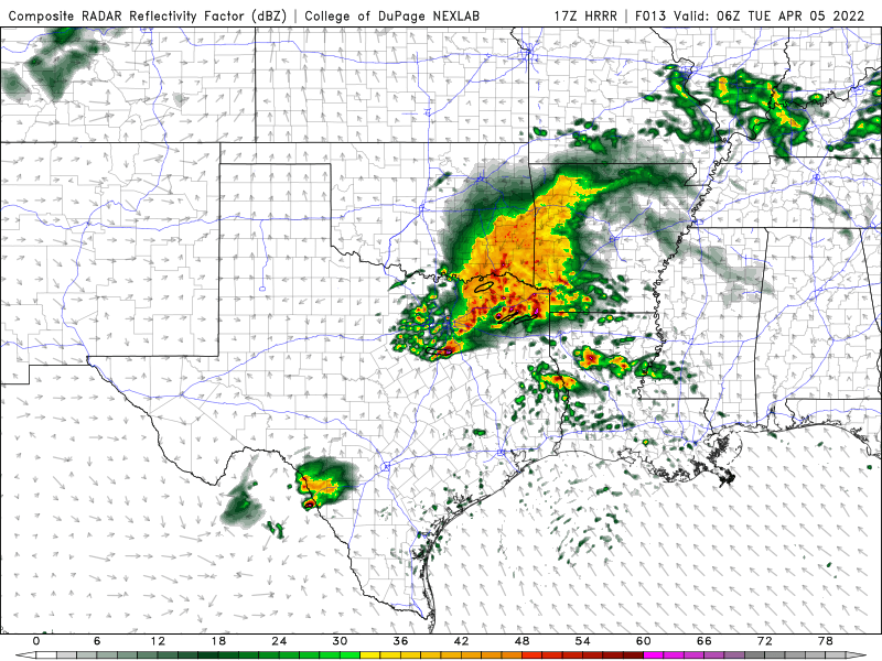
Latest HRRR runs hinting at discrete supercell activity near/to the south of DFW late this evening into the overnight
-
Starting to unzip in portions of AR and far N LA. That Haynesville cell just went severe warned.
-
Cell near Earth, TX could be the first major player of the day eventually.
-
Central/Western Medium-Long Range Discussion
Derek30 replied to andyhb's topic in Central/Western States
Could be a decent stretch into next week as well with a rather strong ridge encompassing the eastern US and prolonged SW flow aloft for the northern Plains and southern Canada -
Central/Western Medium-Long Range Discussion
Derek30 replied to andyhb's topic in Central/Western States
Leaning towards the GFS solution over the NAM for Friday. Surge of moisture leads to increase in instability especially late into Friday night in MB. Not really seeing a surface based threat but instead a classic MCS/elevated scenario along and north of the warm front heading into Saturday morning. You folks think southwest MB could be a surface based play at some point Friday? Tough call as models hint at a dying MCS in that area early. MB historically has had a hard time with afternoon recovery behind MCS activity but we shall see. -
Central/Western Medium-Long Range Discussion
Derek30 replied to andyhb's topic in Central/Western States
Anyone coming up north in the coming weeks may need to bring their passports. Looks like the potential for a good setup or two in SK/MB ahead. -
Central/Western Medium-Long Range Discussion
Derek30 replied to andyhb's topic in Central/Western States
GFS has been hinting at big things for the central and northern Plains in early to mid June. Big time ridge followed by western troughing and the jet shifting north. -
Central/Western Medium-Long Range Discussion
Derek30 replied to andyhb's topic in Central/Western States
Keep an eye on Sunday as well. Low progresses east and the trough finally approaches. Should be good forcing along with appreciable moisture and instability. -
Central/Western Medium-Long Range Discussion
Derek30 replied to andyhb's topic in Central/Western States
Yeah, E SK looks to be the best bet tomorrow and Thursday. Ridge is overhead for S MB with MCS potential increasing both nights. E SK should see a few supercells with the highest risk on Thursday. -
Central/Western Medium-Long Range Discussion
Derek30 replied to andyhb's topic in Central/Western States
Thursday looks volatile on top of the ridge in southern Manitoba. Reminds me a bit of a certain setup 9 years ago. Northern Plains also look active next weekend as the ridge breaks down. 6z and 12z GFS depicting a very strong low in ND. -
Devastating tornado strikes Joplin, Missouri
Derek30 replied to Hoosier's topic in Weather Forecasting and Discussion
Thank you! -
Devastating tornado strikes Joplin, Missouri
Derek30 replied to Hoosier's topic in Weather Forecasting and Discussion
Can someone provide a link to the discussion thread for this event? I can't seem to track it down. Thanks. -
Historic Tornado Outbreak April 27, 2011
Derek30 replied to CUmet's topic in Weather Forecasting and Discussion
Good lord. That is one hell of a scary skycam. If this continues to track the way it is, there will be devastation in Tuscaloosa. Hoping for the best!
