

penndotguy
-
Posts
1,624 -
Joined
-
Last visited
Content Type
Profiles
Blogs
Forums
American Weather
Media Demo
Store
Gallery
Posts posted by penndotguy
-
-
31F dp13 I think at the onset of precipitation the temps will fall back a bit and most will see snow/sleet most of the afternoon still thinking 2-3” out here before we mix and rain this evening.
-
3 minutes ago, Ralph Wiggum said:
I don't have a good feel about next week if I'm being totally honest and not the usual wiggum playing devils advocate sorta thing. We've been teased with the eps mega snow mean TWICE this season already, and both times, the mid Atlantic took the brunt and we got advisory type stuff.
We are in a Nina. And so far climo has played out with Delaware and South Jersey taking the bulk of the storms.
Why would this be different? Seriously, change my mind that this is going to morph into even a low-end MECS for SE PA? I just am getting bad vibes from the minute the GFS mirrored March 2001 last night. Prove me wrong.
I’m afraid to say the trend all season has been South no reason at this point to think any different. I think we’ll know by Sunday if Lucy is warming up or not. I’ve Nickle and dimed my way to 15” so far
-
 1
1
-
-
18 minutes ago, Albedoman said:
I want to give all you snow weenies out there a heads up. I am currently employed as a township consultant for planning. (Yeah retirement hogwash need the bucks LOL) Last night at the local township meeting, I was told by the public works director that they been told by salt suppliers that many (dozens) municipalities are OUT OF SALT. They the township maybe resorting to sand. The salt suppliers were told it will be 10-15 days before the municipalities y will be resupplied. Will not help after Sunday thats for sure. I expect a state disaster will be issued sometime after Sunday for any major storm over 6" so as the salt bins can filled in a hurry. The media has been kept out the picture on this entire situation but not for long because what municipality wants to broadcast to the media that they are out of salt or have a limited amount to their residents? Yes these numerous "nuisance" storm events have quickly escalated to a road disaster as many municipalities have already expended their salt budget twice over. Once the news gets out folks, hold on to hat. Thus far the media is too damn busy covering social BS and Trump doings. They better worry about their own dam backyard first as I always say.
I got news for ya there has been articles written about this on the WFMZ news, this past week so it’s out there already
-
1
-
-
12 minutes ago, Mikeymac5306 said:
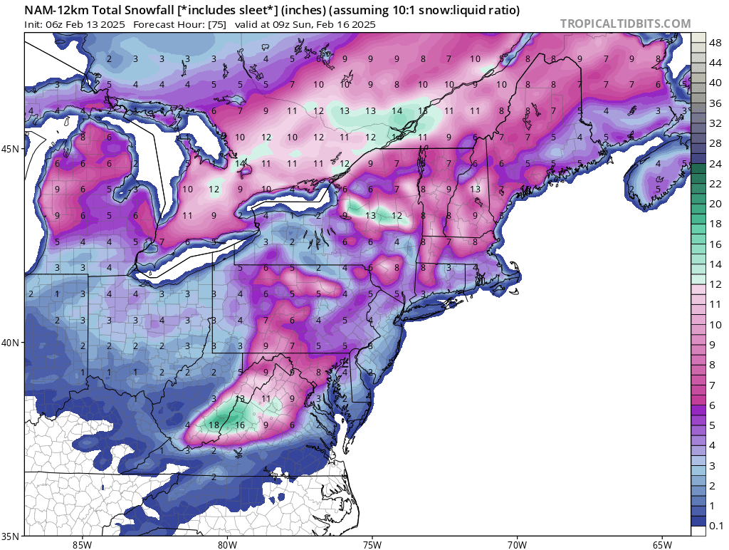
6Z NAM Saturday FWIW.
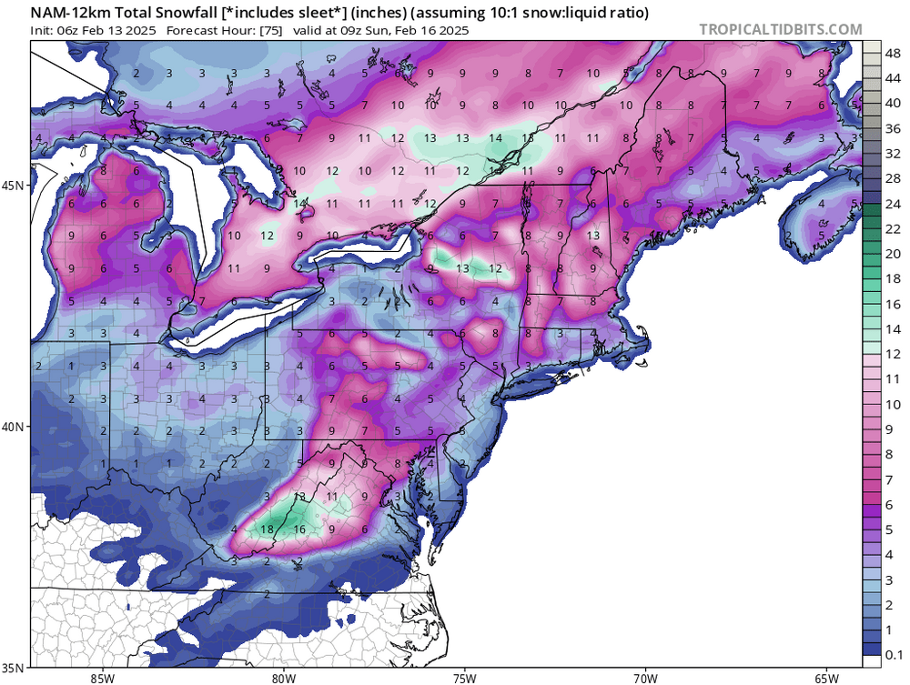
The Saturday looks like it could be a nice little event no ones talking about especially N&W burbs
-
45 minutes ago, Kevin Reilly said:
I think that ship has sailed here 33f humidity 96% dew point 33f light drizzle and rain already too warm at surface and aloft.
Same here in Berks temp 33F dp31 with drizzle, can’t see the temp dropping from here
-
1
-
-
29F total 1.2”
-
1
-
-
Just took quick measurement of .60 headed back to bed tally up in the morning
-
29F with snow, not sure when it started but a decent coating on all surfaces
-
30F not a flake to be found
-
1
-
-
1 hour ago, Duca892 said:
Something something right where we want it let’s roll!!!!
That used to be the theme, not so much anymore.
-
1 hour ago, RedSky said:
oops we lost to a southern slider at 12z
That sounds like a lock for sure, cutter or slider lock it in.
-
 1
1
-
-
Not gonna do it, but hey I called for a MECS this winter back in early December, maybe this is it? Let’s get this inside 5 days

-
I remember a month ago being kinda pumped for this Classic winter pattern setting up, instead we got the classic screw pattern.
-
2 hours ago, JTA66 said:
Bar set at passing snow showers, perhaps a dusting with lollies of a coating, 24F/DP 20F
Looking at the radar I tend to agree especially us up this way, I get it when the low pops off the coast the precip shield will expand a bit but I hate waiting for that been burned before
-
36F dp22 My thinking for Berks County is 2-4 the higher totals southern Berks. Then wave 2 C-1 then some mixing then rain.
-
2
-
-
6 minutes ago, Mikeymac5306 said:
Nah its gonna be a big one trust me. I am flying out to Vegas on the 23rd.
You’ll be fine, when have these ever worked out for us.
-
1
-
-
Temp dropped to 28F it looks like the ice age out there I measured .75” of sleet very little freezing rain, it appears to have ended
-
30F moderate sleet all surfaces covered
-
31F sleet fest has begun
-
31F dp22 nothing falling yet
-
1 hour ago, ChescoWx said:
Radar starting to blossom out here in NW Chesco....saw a couple sleet pellets so far - temp 30.0 degrees DP 11.7 (I smell a sleet fest incoming)
I’ll take a decent sleet fest was pretty good couple days ago, hopefully we can surpass .5” hey it’s winter right? may as well be something frozen.
-
7 minutes ago, ChescoWx said:
We also have the NBM ticking up from its s 6z run....if you choose to believe!!

As I stated yesterday today is when I’ll start paying attention to the the Tuesday thru Wednesday event. Mt Holly still seems to think we get a plowable event. The trends good or bad should start to resolve by Sunday, hopefully.
-
1
-
-
26F Dp16 clouds starting to filter the Sun, thinking 1-3 snow/sleet out here In Berks co.
-
Not one of these 300+hr fantasy storms have been close to reality over the past few years, until one gives us a fraction of the fantasy totals I’m not buying any of them even if the pattern looks great. Let’s get these inside 5 days then maybe we believe.
-
1
-
 1
1
-
1
-
February 15-16 Slop Fest/Rain/Wind OBS
in Philadelphia Region
Posted
31F with very light snow