

north pgh
-
Posts
3,009 -
Joined
-
Last visited
Content Type
Profiles
Blogs
Forums
American Weather
Media Demo
Store
Gallery
Everything posted by north pgh
-
 Models definitely improved today. Looking better for cold and maybe some snow the week before Christmas. Fingers crossed
 -
GFS Dec 13-19 the cold air is here. That will be the time for something if it holds.
-
Fall 2022 Pittsburgh/Western PA Discussion
north pgh replied to Ahoff's topic in Upstate New York/Pennsylvania
Remember the last few years the long term models weren't very good. Many storms seemed to pop up in the 5-7 day period. Being optimistic. -
Fall 2022 Pittsburgh/Western PA Discussion
north pgh replied to Ahoff's topic in Upstate New York/Pennsylvania
Mesoscale Discussion 1974 NWS Storm Prediction Center Norman OK 1119 AM CST Sun Nov 27 2022 Areas affected...Upper Ohio Valley Concerning...Severe potential...Watch unlikely Valid 271719Z - 271915Z Probability of Watch Issuance...20 percent SUMMARY...Isolated strong/damaging winds will be possible in parts of the upper Ohio Valley region this afternoon. DISCUSSION...Shallow convection has very slowly deepened along the cold front in southeast Ohio to near West Virginia border. A small region of mid 50s F dewpoints within this region is supporting 250-500 J/kg MUCAPE. Regional VAD profiles show 40-60 kts of flow within the lowest 2 km. Though convection will likely remain shallow and produce little lightning, isolated strong/damaging gusts will be possible as surface heating continues this afternoon. Within the last hour, a gust of 37 kts was observed near Chillicothe, OH and 47 kts was observed at Huntington, WV. Given the low-level inversions present on the 12Z observed ILM/PBZ soundings, low-level lapse rates are not expected to become overly steep even with more heating. The shallow convection will likely be the primary mechanism for stronger gusts this afternoon. ..Wendt/Hart.. 11/27/2022 ...Please see www.spc.noaa.gov for graphic product... ATTN...WFO...CTP...LWX...PBZ...RLX...ILN... LAT...LON 39818266 40428121 40717986 40387904 39897887 38758039 38378185 38558251 38808270 39818266 Top/All Mesoscale Discussions/Forecast Products/Home Weather Topics: -
Fall 2022 Pittsburgh/Western PA Discussion
north pgh replied to Ahoff's topic in Upstate New York/Pennsylvania
Sun is out. Picked up a quick 1/2 inch. -
Nice Graupel snow shower moving thru.
-
Picking up in intensity again. Silver dollar flakes.
-
Still moderate snow here. Close to an inch. I am at a higher elevation.
-
Fall 2022 Pittsburgh/Western PA Discussion
north pgh replied to Ahoff's topic in Upstate New York/Pennsylvania
Moderate snow with big fluffy flakes. Covering the grassy areas and rooftops. -
Fall 2022 Pittsburgh/Western PA Discussion
north pgh replied to Ahoff's topic in Upstate New York/Pennsylvania
1.95 here so far today. -
Fall 2022 Pittsburgh/Western PA Discussion
north pgh replied to Ahoff's topic in Upstate New York/Pennsylvania
Anyone else getting ready for winter? I've officially started looking at models. -
Pittsburgh/Western PA Summer 2022 Discussion
north pgh replied to Ahoff's topic in Upstate New York/Pennsylvania
Wow! That was quite a Lightning show. A solid hour of ctg lightning and .78 inches of rain. My kind of night-time thunderstorm ⚡️⚡️ -
Pittsburgh/Western PA Summer 2022 Discussion
north pgh replied to Ahoff's topic in Upstate New York/Pennsylvania
Yes lot's of lightning and thunder. 1.62 inches of rain in my gauge since midnight last night. I love storms when you can just lie in bed and relax. -
Pittsburgh/Western PA Summer 2022 Discussion
north pgh replied to Ahoff's topic in Upstate New York/Pennsylvania
Got slammed here in the North Hills. 1.38 inches of rain. Hail and winds had to be 60+. Tree branches and a lot of debris on the roads. -
Pittsburgh/Western PA Summer 2022 Discussion
north pgh replied to Ahoff's topic in Upstate New York/Pennsylvania
Mesoscale Discussion 1191 NWS Storm Prediction Center Norman OK 0231 PM CDT Thu Jun 16 2022 Areas affected...northeastern Ohio into western Pennsylvania. Concerning...Severe Thunderstorm Watch 375... Valid 161931Z - 162100Z The severe weather threat for Severe Thunderstorm Watch 375 continues. SUMMARY...Ongoing storms, will continue eastward with a risk for damaging wind gusts and hail. Storms with supercellular characteristics are maturing suggesting a localized greater severe potential downstream into PA. DISCUSSION...As of 1915 UTC, regional radar analysis showed scattered thunderstorms maturing ahead of a pre frontal trough/lake breeze boundary across portions of northeastern OH and northwestern PA. Supercell characteristics have emerged on two of the more dominant storms (Ashtabula/Trumbull and Wayne/Holmes counties) in OH suggesting a locally greater risk of damaging wind gusts and severe hail. While lapse rates are not particularly steep (7 C/km), 40+ kt of effective shear from the 19z PBZ special sounding should continue to support supercells capable damaging winds and potentially hail near 2 inches. Additional severe storm development will be possible farther west into central OH, though uncertainty remains higher. ..Lyons.. 06/16/2022 ...Please see www.spc.noaa.gov for graphic product... ATTN...WFO...CTP...PBZ...CLE...ILN... LAT...LON 40847917 40357930 40257969 40128032 40148083 40148185 40118275 40358279 40848212 41528111 41848033 41947964 41887931 41727921 41537915 41077915 40847917 -
Pittsburgh/Western PA Summer 2022 Discussion
north pgh replied to Ahoff's topic in Upstate New York/Pennsylvania
-
Pittsburgh/Western PA Spring 2022 Discussion Thread
north pgh replied to Ahoff's topic in Upstate New York/Pennsylvania
This is about as accurate as I have ever seen the 18HRRR match up with current.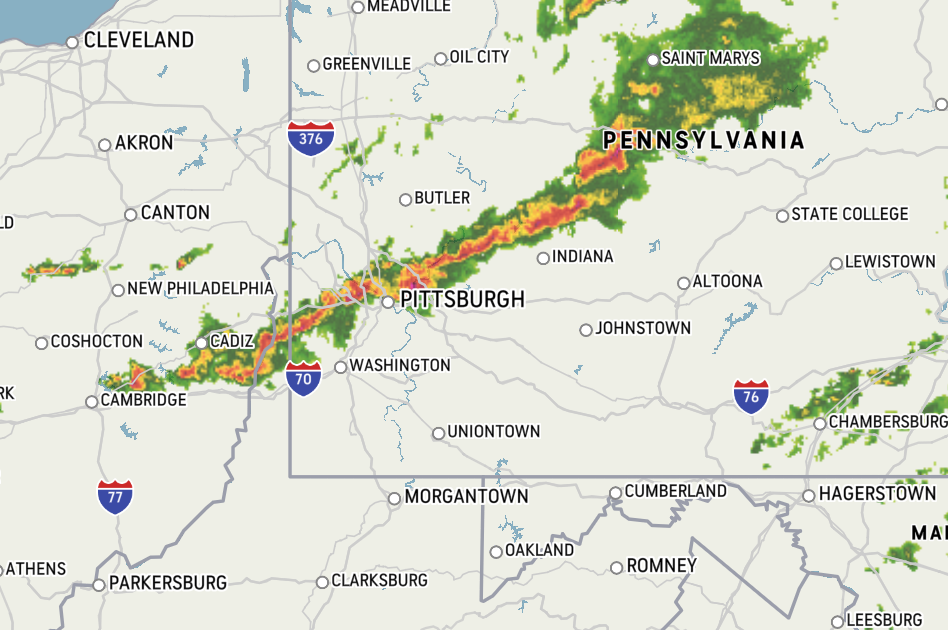
-
Pittsburgh/Western PA Spring 2022 Discussion Thread
north pgh replied to Ahoff's topic in Upstate New York/Pennsylvania
My temp has jumped to 79. Dewpoint is up to 68. You can feel the humidity kicking in. -
Pittsburgh/Western PA Spring 2022 Discussion Thread
north pgh replied to Ahoff's topic in Upstate New York/Pennsylvania
Yep. No overnight storms. Nice complex may come through around 9 or 10 am -
Pittsburgh/Western PA Spring 2022 Discussion Thread
north pgh replied to Ahoff's topic in Upstate New York/Pennsylvania
I just know from my history of storms that when I see elevated thunderstorms in forecast discussions they are usually ahead of warm fronts moving from the southwest to northeast. Most times they seem to come overnight. I like them because they usually are not severe but can have a lot of lightning. I always enjoyed the overnight storm with the rain and the lightning. I don't know if it has anything to do with making it warmer. What I meant was that knowing the storms were coming ahead of the front and storms in the morning we can sometimes clear out in the afternoon and the temp will rise fast mainly from the front itself. Just an observation on my part. I am not a met. Just going from experience. https://www.weather.gov/source/zhu/ZHU_Training_Page/thunderstorm_stuff/elevated_convection/elevated_convection.html -
Pittsburgh/Western PA Spring 2022 Discussion Thread
north pgh replied to Ahoff's topic in Upstate New York/Pennsylvania
For Thunderstorm lovers it looks like a decent chance of some elevated storms moving in after 2:00 am overnight. My favorite kind. Usually no severe but some decent lightning. Maybe if we get them it will help raise temps tomorrow over 90. -
Pittsburgh/Western PA Spring 2022 Discussion Thread
north pgh replied to Ahoff's topic in Upstate New York/Pennsylvania
I agree. Just eliminate the extremes. Let's get some constant 70+ degree days with fronts twice a week with 4 or 5 days of dry weather instead of every other day we get a new system with precip. -
Western PA/Pittsburgh Winter 2021/22 Discussion
north pgh replied to meatwad's topic in Upstate New York/Pennsylvania
Big flakes are flying now starting to stick. -
Pittsburgh/Western PA Spring 2022 Discussion Thread
north pgh replied to Ahoff's topic in Upstate New York/Pennsylvania
I am currently at 78 -
Western PA/Pittsburgh Winter 2021/22 Discussion
north pgh replied to meatwad's topic in Upstate New York/Pennsylvania
I believe they missed some potential snow squall warnings last week. Today no. I believe temps have to be below freezing which they are not today. I love spring snow showers. Nice cumulus cloud formation with sun and stormy looks.

