

north pgh
-
Posts
3,012 -
Joined
-
Last visited
About north pgh

-
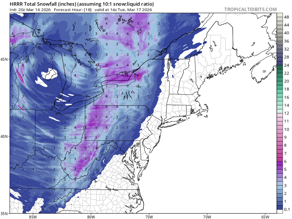
Another stormy night on the way!
-

Pittsburgh/Western PA WINTER ‘25/‘26
north pgh replied to Burghblizz's topic in Upstate New York/Pennsylvania
I just took out the dog and was getting some light sleet. -
Pittsburgh/Western PA WINTER ‘25/‘26
north pgh replied to Burghblizz's topic in Upstate New York/Pennsylvania
These March days remind me of being outside in the 70’s. Snow on the ground, birds chirping, the sun comes out and you feel the warmth from it, then it gets dark and a squall comes thru and re-whitens the ground……. Rinse and repeat. -
Pittsburgh/Western PA WINTER ‘25/‘26
north pgh replied to Burghblizz's topic in Upstate New York/Pennsylvania
4 inches here. -
Pittsburgh/Western PA WINTER ‘25/‘26
north pgh replied to Burghblizz's topic in Upstate New York/Pennsylvania
-
Pittsburgh/Western PA WINTER ‘25/‘26
north pgh replied to Burghblizz's topic in Upstate New York/Pennsylvania
I guessing a good chance of a tornado watch this afternoon -
Pittsburgh/Western PA WINTER ‘25/‘26
north pgh replied to Burghblizz's topic in Upstate New York/Pennsylvania
Looking forward to some possible thunderstorms overnight and tomorrow. . -
Pittsburgh/Western PA WINTER ‘25/‘26
north pgh replied to Burghblizz's topic in Upstate New York/Pennsylvania
I'll gladly take 3-5 inches on Sunday night/Monday morning -
Pittsburgh/Western PA WINTER ‘25/‘26
north pgh replied to Burghblizz's topic in Upstate New York/Pennsylvania
Nice...GFS (In the game) -
Pittsburgh/Western PA WINTER ‘25/‘26
north pgh replied to Burghblizz's topic in Upstate New York/Pennsylvania
A solid inch and a half sticking to everything. Nice viewing as I take the dog out at 5:30. -
Pittsburgh/Western PA WINTER ‘25/‘26
north pgh replied to Burghblizz's topic in Upstate New York/Pennsylvania
Yes most models are showing about 6-10 inches less than projected. Still I nice snowfall but a lot of people thinking they were getting 20 inches will be disappointed if they only get 10. -
Pittsburgh/Western PA WINTER ‘25/‘26
north pgh replied to Burghblizz's topic in Upstate New York/Pennsylvania
Same here, except 2 inches on the grass. Beautiful morning. Don’t have to shovel -
Pittsburgh/Western PA WINTER ‘25/‘26
north pgh replied to Burghblizz's topic in Upstate New York/Pennsylvania
Just got home. Snow coming down and whitening the ground. Maybe we can eak out an inch overnight. -
Pittsburgh/Western PA WINTER ‘25/‘26
north pgh replied to Burghblizz's topic in Upstate New York/Pennsylvania
50 + MPH wind gusts. Thunderstorms last night and a couple inches of snow Sunday -Monday. Gotta love this weather. -
Pittsburgh/Western PA WINTER ‘25/‘26
north pgh replied to Burghblizz's topic in Upstate New York/Pennsylvania
It woke me up. It gets me anxious for spring storms

