

Stormpc
-
Posts
3,191 -
Joined
-
Last visited
Content Type
Profiles
Blogs
Forums
American Weather
Media Demo
Store
Gallery
Posts posted by Stormpc
-
-
All that severe weather talk and I didn't even see a drop of rain yesterday. Nothing on the south side of Hampton Roads nor in Northeast North carolina. We'll see what happens later today.
-
Should have never brought back Hyde after last season's playoff debacle. Now it's possibly a Lost season. Actually most definitely. Elias did nothing since last year's trade deadline. Poorly spent money. What was once looking like a several year window has closed. What a mess. Orioles fans don't deserve this.
-
Bring Buck Britton up from norfolk. Long time with the organization. Managed all of these young guys. Time for a change. Then send Elias packing when the season is over.
-
Hyde AND Elias need to go. Elias fell asleep at the wheel and did nothing the past year to improve the team in many areas. Meanwhile no one's listening to the skipper anymore. His young players have regressed. They've been in this Swoon since middle of last year. They need a new voice in the clubhouse and within management. I hope ownership does something soon.
-
 1
1
-
-
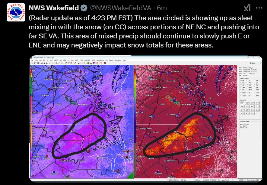
EXPECT AN INCREASE IN ORGANIZATION AND INTENSITY OF THE SQUALL LINE
(FIRST INDICATED BY THE PRESENCE OF LIGHTNING) WITHIN THE NEXT 1 TO
2 HOURS WITH THE THREAT PERSISTING THROUGH THE AFTERNOON/EVENING. AN
ADDITIONAL TORNADO WATCH WILL EVENTUALLY BE NEEDED DOWNSTREAM OF
WATCH 26 ACROSS PARTS OF EASTERN NORTH CAROLINA AND SOUTHEAST
VIRGINIA.-
 1
1
-
-
18 minutes ago, wasnow215 said:
I wonder when Wakefield will put out severe storm watches?
Those come from the Storm Prediction Center I believe. And yes I bet they'll probably extend it east and north as we get through the morning
-
1
-
-
I've been watching that little disturbance tonight as the cold air deepens around Hampton Roads and Northeast North carolina. Some of the mesos are trying to throw in a rain snow mix or some flurries. Obviously nothing's going to happen of significance but just something to watch.
-
 1
1
-
-
42 minutes ago, ldub23 said:
If you hadnt got that sleet you may have hit 15. As i type getting a last dying flurry
There's no doubt about it. All those locations are within 2 miles of my house either side north or south and we all had a good 75 minutes of power sleet. I guess flirting with that line as its benefits in the end.
-
1
-
-
Big thanks to @Ric Airport. Always there to post a model run and provide current and historic data. We're going to miss you for certain.
-
5
-
-
CURRITUCK COUNTY 2 NNW CURRITUCK 14.0 IN 0120 PM 02/20 EMERGENCY MNGR
KNOTTS ISLAND 13.0 IN 0120 PM 02/20 EMERGENCY MNGR
SLIGO 12.0 IN 0120 PM 02/20 EMERGENCY MNGR
MAPLE 12.0 IN 0120 PM 02/20 EMERGENCY MNGR
3 NNE SLIGO 12.0 IN 0120 PM 02/20 EMERGENCY MNGR
2 WNW MOYOCK 12.0 IN 0120 PM 02/20 EMERGENCY MNGR
COROLLA 11.0 IN 0120 PM 02/20 EMERGENCY MNGR AYDLETT
-
2
-
-
I ended up with around 12 inches give or take. Matches well with the areas of Currituck around me that had 12-14 inches per Wakefield.
-
3
-
-
We are still getting heavy rates down here just South of the Border in North Carolina along the coast. The totals all across the board are going to be impressive to say the least. A storm that reached the higher ends of the forecasted amounts. Very well modeled for this small geographic region as well. Nice job. This will probably be it for us. And that's perfectly fine. A great winter. A+ for my area for sure. Two 7+ inch snow events in season. What a rarity.
Doesn't look like we're going to get much action from the upper energy tomorrow but we'll see. Those are always tricky. Tomorrow night's cold is going to be impressive. Good night all and congrats.
-
3
-
1
-
1
-
-
2 minutes ago, Coach McGuirk said:
the southside beat the peninsula, cograts.
It's still ripping as well. Impressive throughout all of the HR.
-
1
-
-
Hampton Roads cashing in on a great event. Heavy snow piling up after that late afternoon sleet fest. Windy, blowing and drifting ongoing. Temps down to 27.5 after getting over 31 a few hours ago. Came close to plain rain. GREAT EVENT. Not looking forward to shoveling my snow that is layered with sleet. Not the fluffy stuff like y'all have further North. Have a legit shot at double digits.
-
4
-
1
-
-
17 minutes ago, chris624wx said:
Absolutely puking snow in Norfolk right now!
Same here. A snow fog. Small flakes here. Bad growth upstairs. My temp went above 31 for a time, backed down to 29.5 now. Mix line may try another surge later.
-
2
-
-
I am back to all snow mostly... for at least 30 minutes or so. Still bursts of sleet as well.
-
2
-
-
20 minutes ago, yotaman said:
Either big fat flakes or sleet.
I had about 1 hour and 20 minutes of pure sleet. It's back to snow sleet mix now, hence the bright banding, but that did a number on the weight of the nearly 4 inches that fell just before it flipped. I tried to move some of it out of the driveway and it was pure cement.
-
50/50 snow sleet mix. Monster parachutes coming down now. Right on that edge.
-
1
-
-
Looks like that warm nose that was in Central North Carolina around RDU shot Northeast. Odd configuration where it was snowing south and east of the nose. They are back to pure snow SW of here.
-
1
-
-
Heavy sleet!! I guess it'll keep the 3.5-4 inches we got already from blowing away. Let's see if this is going to mix out
-
8 minutes ago, Stormpc said:
That's actually a burst of heavy snow. 2 inch an hour stuff
I spoke too soon. There's definitely an ice component to this right now. Lots of sleet!!!
-
 2
2
-
-
9 minutes ago, RIC Airport said:
Sleet line looks to be headed your way and parts of southside HR.
That's actually a burst of heavy snow. 2 inch an hour stuff
-
1
-
 1
1
-
-
9 minutes ago, aldie 22 said:
Is that push broom your shovel?

Flagpole
-
4 minutes ago, Heisy said:
Based on the radar I can’t imagine they get less than 8-9”, 10-14” would be final guess
.I agree, especially if they don't mix a little later this evening. It's really just getting started in these parts
Richmond Metro/Hampton Roads Area Discussion
in Mid Atlantic
Posted
Wakefield and all the local Mets are a little shy on pulling the trigger for the Thursday/Friday Coastal system. It's becoming more apparent it's coming north and should get well into Coastal North Carolina and at least the south side of Hampton Roads with showery East Wind driven rain. As we get closer it'll be interesting to see the details. Euro is now on board