

CoastalWx
-
Posts
175,992 -
Joined
-
Last visited
Content Type
Profiles
Blogs
Forums
American Weather
Media Demo
Store
Gallery
Everything posted by CoastalWx
-
Active mid December with multiple event potential
CoastalWx replied to Typhoon Tip's topic in New England
We love -
Active mid December with multiple event potential
CoastalWx replied to Typhoon Tip's topic in New England
For all. -
Active mid December with multiple event potential
CoastalWx replied to Typhoon Tip's topic in New England
18z eps looks good. -
Active mid December with multiple event potential
CoastalWx replied to Typhoon Tip's topic in New England
What a storm. There was about 2’ where I am now. I had 17” iirc in Dorchester. -
Active mid December with multiple event potential
CoastalWx replied to Typhoon Tip's topic in New England
I just looked at BOS. -
Active mid December with multiple event potential
CoastalWx replied to Typhoon Tip's topic in New England
LOL, it may be wrong, but it isn't outrageous. 6-9 for BOS is outrageous? -
Active mid December with multiple event potential
CoastalWx replied to Typhoon Tip's topic in New England
It's not outrageous. If it trends warmer or NW, then it will be right. -
Active mid December with multiple event potential
CoastalWx replied to Typhoon Tip's topic in New England
That run was a little better here. Snows into Thursday evening. -
Active mid December with multiple event potential
CoastalWx replied to Typhoon Tip's topic in New England
Yeah so strange. Agree Thursday morning looks good. -
Active mid December with multiple event potential
CoastalWx replied to Typhoon Tip's topic in New England
Meh nothing reallY notable on euro. Loving the offshore convection. -
Active mid December with multiple event potential
CoastalWx replied to Typhoon Tip's topic in New England
It does have a topographic fetish. -
Active mid December with multiple event potential
CoastalWx replied to Typhoon Tip's topic in New England
I just don’t exactly understand why the gulf. More of the uncertainty is out west. -
Active mid December with multiple event potential
CoastalWx replied to Typhoon Tip's topic in New England
I want a Mar 2019 blob moving over my fanny. -
Active mid December with multiple event potential
CoastalWx replied to Typhoon Tip's topic in New England
-
Active mid December with multiple event potential
CoastalWx replied to Typhoon Tip's topic in New England
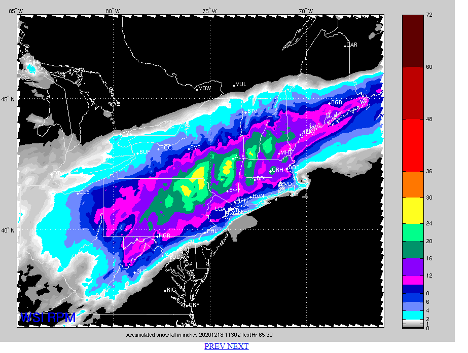
RPM is Ray approved. -
Active mid December with multiple event potential
CoastalWx replied to Typhoon Tip's topic in New England
Wearing a crown of Fenway franks. -
Active mid December with multiple event potential
CoastalWx replied to Typhoon Tip's topic in New England
You can picture him carrying his heavy wooden shovel and laptop up 95 as he falls several times in doing so. -
Active mid December with multiple event potential
CoastalWx replied to Typhoon Tip's topic in New England
I think Will put it nicely. I don't have the confidence or certainty to say it's near your hood right now. -
Active mid December with multiple event potential
CoastalWx replied to Typhoon Tip's topic in New England
EPS were a tad stronger and NW of 6z. Not by a whole lot though. -
Active mid December with multiple event potential
CoastalWx replied to Typhoon Tip's topic in New England
Yeah the shield blew up nicely. -
Active mid December with multiple event potential
CoastalWx replied to Typhoon Tip's topic in New England
Looks like the vort was further east at 12z thursday. -
Active mid December with multiple event potential
CoastalWx replied to Typhoon Tip's topic in New England
Civil war breaking out. -
Active mid December with multiple event potential
CoastalWx replied to Typhoon Tip's topic in New England
The model resolution picking out the coastline with NE winds. Basically saying beaches may get less snow vs a few miles inland. -
Active mid December with multiple event potential
CoastalWx replied to Typhoon Tip's topic in New England
He still is recovering from the Valentines Day massacre of 2015. Well more like 2/15/15. One of the last posts when the models showed a PWM jack that day was "we take." -
Active mid December with multiple event potential
CoastalWx replied to Typhoon Tip's topic in New England
Ukie is pretty nice near BOS. That's going to be quite the man snow where it does not taint, and on warm side of CF. I guess for those on the edge, looks like cstl areas will get a lot of light moods snows into Thursday evening that could drop an extra inch or two.


