

CoastalWx
-
Posts
177,031 -
Joined
-
Last visited
Content Type
Profiles
Blogs
Forums
American Weather
Media Demo
Store
Gallery
Everything posted by CoastalWx
-
Monitoring a potential important TV to East Coastal storm: Jan 17
CoastalWx replied to Typhoon Tip's topic in New England
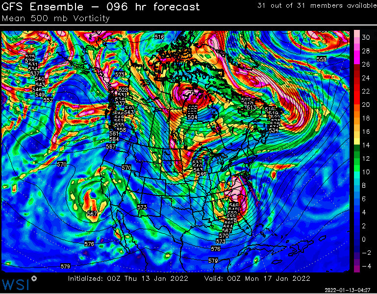
So to me this makes sense. Compare 00z GEFS and 06z GEFS. - At 00z Monday you can see the srn stream on the 6z run is a bit east of the 00z position. - Nrn stream at 06z appears a little more strung out and weaker. All the energy at 00z is in the back of the s/w which will tighten it up. - Confluence north of New England looks better, especially as you advance 12 hrs.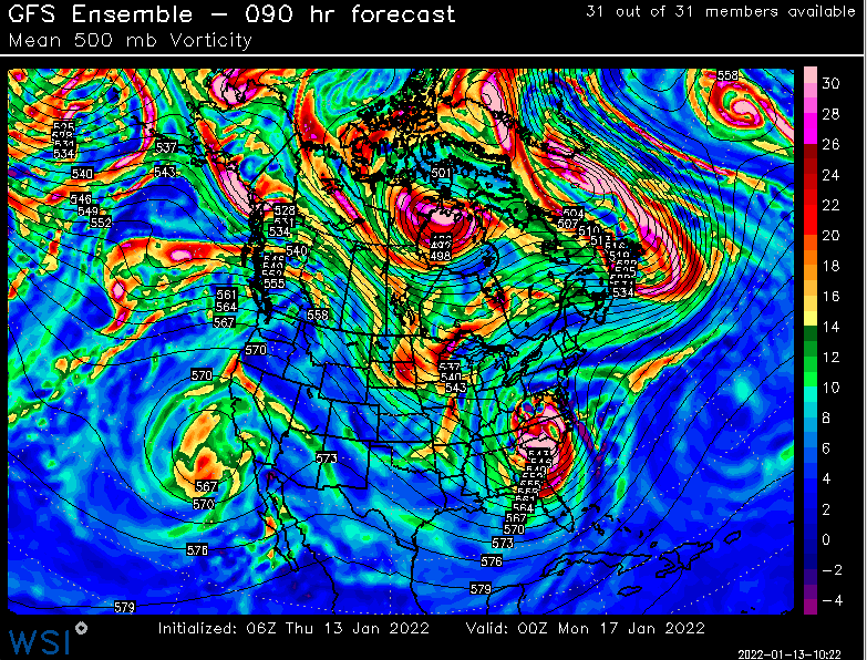
-
Monitoring a potential important TV to East Coastal storm: Jan 17
CoastalWx replied to Typhoon Tip's topic in New England
He's gone wild again. -
Monitoring a potential important TV to East Coastal storm: Jan 17
CoastalWx replied to Typhoon Tip's topic in New England
I don't know what to say on that. -
Monitoring a potential important TV to East Coastal storm: Jan 17
CoastalWx replied to Typhoon Tip's topic in New England
Are you trying to tell me how to forecast? -
Monitoring a potential important TV to East Coastal storm: Jan 17
CoastalWx replied to Typhoon Tip's topic in New England
Edibles -
Monitoring a potential important TV to East Coastal storm: Jan 17
CoastalWx replied to Typhoon Tip's topic in New England
It certainly matters. A track near CHH would greatly limit the influx of warm air from the ocean to like 925-850. -
Monitoring a potential important TV to East Coastal storm: Jan 17
CoastalWx replied to Typhoon Tip's topic in New England
Not if he counts every 0.1” -
Monitoring a potential important TV to East Coastal storm: Jan 17
CoastalWx replied to Typhoon Tip's topic in New England
Of Course it matters lol. -
Monitoring a potential important TV to East Coastal storm: Jan 17
CoastalWx replied to Typhoon Tip's topic in New England
If we could all disrobe over upslope like you. -
Monitoring a potential important TV to East Coastal storm: Jan 17
CoastalWx replied to Typhoon Tip's topic in New England
That’s because he’s Santa’s neighbor. -
Monitoring a potential important TV to East Coastal storm: Jan 17
CoastalWx replied to Typhoon Tip's topic in New England
I still have no idea how to read those sensitivity charts, but makes sense knocking down the ridge a bit would shove things east down. Although I think a strong nrn vort is a risk of picking up the srn vort. -
Monitoring a potential important TV to East Coastal storm: Jan 17
CoastalWx replied to Typhoon Tip's topic in New England
Because in general it’s better than the GEFS. Too many weenies using anecdotal evidence. I will say the GEFS have done better long term. -
Monitoring a potential important TV to East Coastal storm: Jan 17
CoastalWx replied to Typhoon Tip's topic in New England
Gfs op still sucked south of pike even inland. I wouldn’t lose my wad to that. -
Monitoring a potential important TV to East Coastal storm: Jan 17
CoastalWx replied to Typhoon Tip's topic in New England
Run. Haha. -
Monitoring a potential important TV to East Coastal storm: Jan 17
CoastalWx replied to Typhoon Tip's topic in New England
I’ll still scold you. -
Monitoring a potential important TV to East Coastal storm: Jan 17
CoastalWx replied to Typhoon Tip's topic in New England
The gfs op had had short term busts too. Whatever models show the most snow, weenie will hump. -
Monitoring a potential important TV to East Coastal storm: Jan 17
CoastalWx replied to Typhoon Tip's topic in New England
I meant op. My bad. -
Monitoring a potential important TV to East Coastal storm: Jan 17
CoastalWx replied to Typhoon Tip's topic in New England
GEFs overall have been better with the long term, but in short term I don’t know if you can say the same. -
Monitoring a potential important TV to East Coastal storm: Jan 17
CoastalWx replied to Typhoon Tip's topic in New England
I won’t say it’s 0% chance, but when everything else is west, it’s tough for me to buy. -
Monitoring a potential important TV to East Coastal storm: Jan 17
CoastalWx replied to Typhoon Tip's topic in New England
6z EPS is out too. Every single model including gfs op is west of the GEFS. They are the outlier. -
Monitoring a potential important TV to East Coastal storm: Jan 17
CoastalWx replied to Typhoon Tip's topic in New England
GEFS are an outlier right now. Good luck. -
Monitoring a potential important TV to East Coastal storm: Jan 17
CoastalWx replied to Typhoon Tip's topic in New England
EPS is so amped. I’ll sell GEFS. Maybe in between, but I don’t see an offshore look with this setup and retreating high. -
Monitoring a potential important TV to East Coastal storm: Jan 17
CoastalWx replied to Typhoon Tip's topic in New England
I’ve seen many instances that screw your and I from more than like 2-3”. That flow is terrible. Get that high slower to retreat and a little more confluence with a low more near the Cape, and it would be much different. -
Monitoring a potential important TV to East Coastal storm: Jan 17
CoastalWx replied to Typhoon Tip's topic in New England
Tossed like your snowblower into the scrap yard. -
Monitoring a potential important TV to East Coastal storm: Jan 17
CoastalWx replied to Typhoon Tip's topic in New England
Get the high north of caribou.


