CoastalWx
-
Posts
176,078 -
Joined
-
Last visited
Content Type
Profiles
Blogs
Forums
American Weather
Media Demo
Store
Gallery
Everything posted by CoastalWx
-
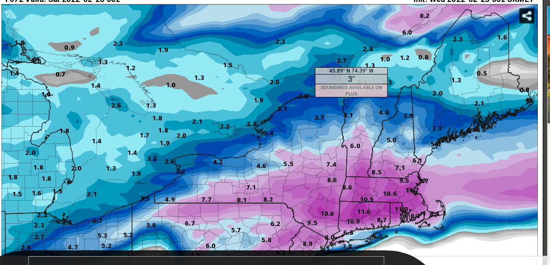
Winter storm for the 25th of February is imminent.
CoastalWx replied to Typhoon Tip's topic in New England
I mean still time for adjustments, but usually this was the time to see the north ticks. -
Winter storm for the 25th of February is imminent.
CoastalWx replied to Typhoon Tip's topic in New England
Well it certainly hasn’t been my best winter in guessing trends. -
Winter storm for the 25th of February is imminent.
CoastalWx replied to Typhoon Tip's topic in New England
Pretty good consensus now aside from the NAM. Was thinking some ticks north were in the cards from some of the other guidance, but so far not yet. -
Winter storm for the 25th of February is imminent.
CoastalWx replied to Typhoon Tip's topic in New England
Ukie a tad warmer than 00z, but still cold as well. -
Winter storm for the 25th of February is imminent.
CoastalWx replied to Typhoon Tip's topic in New England
Canadian went south too. -
Winter storm for the 25th of February is imminent.
CoastalWx replied to Typhoon Tip's topic in New England
That period near dinner time as temps rapidly fall with light snow, could be highway Phil too. At least for you and I. -
Winter storm for the 25th of February is imminent.
CoastalWx replied to Typhoon Tip's topic in New England
Well I would love to be wrong, but tough for me to buy 10-12". -
Winter storm for the 25th of February is imminent.
CoastalWx replied to Typhoon Tip's topic in New England
Nice parting gift on the GFS. -
Winter storm for the 25th of February is imminent.
CoastalWx replied to Typhoon Tip's topic in New England
ARW2 is a nice thump. Colder than the NAM for sure. -
Winter storm for the 25th of February is imminent.
CoastalWx replied to Typhoon Tip's topic in New England
I know, which is why I mentioned waiting for the 12z to adjust amounts. Just noting some of the trends. -
Winter storm for the 25th of February is imminent.
CoastalWx replied to Typhoon Tip's topic in New England
I think you missed the 20 posts explaining the NAM issue here. -
Winter storm for the 25th of February is imminent.
CoastalWx replied to Typhoon Tip's topic in New England
It would be a little -RA which is what I still expect for you and I. -
Winter storm for the 25th of February is imminent.
CoastalWx replied to Typhoon Tip's topic in New England
PVD getting more snow than MHT and by a lot? Come on. -
Winter storm for the 25th of February is imminent.
CoastalWx replied to Typhoon Tip's topic in New England
Do we really need to question why the Ukie is tossed?
-
Winter storm for the 25th of February is imminent.
CoastalWx replied to Typhoon Tip's topic in New England
Some of the north ticks are the result of the shortwave moving north. Euro is one of them. -
Winter storm for the 25th of February is imminent.
CoastalWx replied to Typhoon Tip's topic in New England
I don't really weigh the nam a lot, but I think Dryslot said it, and we all mentioned this ad nauseum with these. They tick north final 72 hours or so. Not sure why some are getting defensive. This is just how they work. -
Winter storm for the 25th of February is imminent.
CoastalWx replied to Typhoon Tip's topic in New England
Ukie is a joke, it's not a defense mechanism, it makes no sense. -
Winter storm for the 25th of February is imminent.
CoastalWx replied to Typhoon Tip's topic in New England
Some knew. -
Winter storm for the 25th of February is imminent.
CoastalWx replied to Typhoon Tip's topic in New England
Reckless? It’s the reality. Tossed. -
Winter storm for the 25th of February is imminent.
CoastalWx replied to Typhoon Tip's topic in New England
Tossed -
Winter storm for the 25th of February is imminent.
CoastalWx replied to Typhoon Tip's topic in New England
HRRR is most certainly warmer than 6z. -
Winter storm for the 25th of February is imminent.
CoastalWx replied to Typhoon Tip's topic in New England
You're on the line, I'd probably slide you into the 8-12 to be honest. -
Winter storm for the 25th of February is imminent.
CoastalWx replied to Typhoon Tip's topic in New England
You should do better than that no? What does GYX have? -
Winter storm for the 25th of February is imminent.
CoastalWx replied to Typhoon Tip's topic in New England
Yeah he can be confusing. He talked about torches, wanting his driveway and chicken path cleared etc. Then he throws fresh eggs around the coop when the euro gave him 6”. -
Winter storm for the 25th of February is imminent.
CoastalWx replied to Typhoon Tip's topic in New England
We tried to tell Brian and Lava.