

Mr. Windcredible!
-
Posts
2,962 -
Joined
-
Last visited
Content Type
Profiles
Blogs
Forums
American Weather
Media Demo
Store
Gallery
Posts posted by Mr. Windcredible!
-
-
GFS says I triple my seasonal snow total in the next 100 hours...I just don’t see that happening.
-
6 minutes ago, Hoth said:
Too funny.
I'm at a whopping 10.5" on the season down here. I so want this winter over and done with...but it's clear that winter isn't done finding new ways to screw us
-
as a S CT resident...all you can do at this point is laugh. then cry. then nervously laugh again. then sob hysterically.
-
3 hours ago, Hoth said:
SCT for the loss again.
The way this winter has gone...I fully expect the bulk of this to miss to the north...and that weak ass Friday system will slide to our south.
-
18 minutes ago, Ginx snewx said:
It has an inch by Wed meh
while DC gets 8-12"
-
1 hour ago, Cold Miser said:
You and I are neck and neck with snow totals right now in our race to winter futility. The 14.5" that I now have includes November where that one shot, 6" snow has been the biggest of the season so far, as well as the month with the most snow for me.
ooo can I play too? haven't even eclipsed 10" yet myself...I'm at about 9.8" after yesterday. honestly yesterday was a bit cathartic despite the low totals just because the timing was perfect to actually be able to enjoy it during daylight hours.
-
 1
1
-
-
33 minutes ago, #NoPoles said:
I didnt check much last night, but i feel like this storm is ahead of schedule. Although im not sure if there is a lot of virga or it actually starts snowing right away
The HRRR had the start time nailed pretty good, about 10am. The NAM was a couple hours slower...didn't have things starting here until about noon.
-
Snow started about 20 min ago here. Just need 1” to make this my biggest event since November. Let’s go!
.-
 1
1
-
4
-
-
You know at this point I can accept a ratter of a winter...but what infuriates me is watching this little Sunday night system morph into a 2-5” deal for Philly/SNJ while the Tuesday event trends toward a sleet to rain scenario here along the shoreline. NYC and S CT/SE MA is just getting boned in every possible way.-
1
-
-
Another bust on the shoreline. A couple min of 2 mi visibility and no more than a dusting. Is it spring yet?
.-
1
-
-
This thing needs to fill in quick or it could be a bust for much of CT
-
Don’t be surprised when even your area struggles to 32. Listen to Will . Surface ain’t warming away from water
I imagine you still have a shot...maybe even down to like Middletown for not getting above 32...but we’re toast here. I’ve seen this show before.
.-
1
-
-
Trends are great in CT for anyone who ever wanted a skating rink in their yard. Flooding rain followed by a flash freeze. I always said I’d prefer a 50 degree rainstorm to a crushing ice storm...I guess I should be happy.
-
 1
1
-
-
1 minute ago, Bostonseminole said:
yeap, thermals remained the same.. even with slightly further north track
smidge warmer at the surface and 850 for CT...but still colder than the Euro. If we see the Euro nudge south at 12z then we certainly could be trending towards a compromise of the two.
-
6 minutes ago, Baroclinic Zone said:
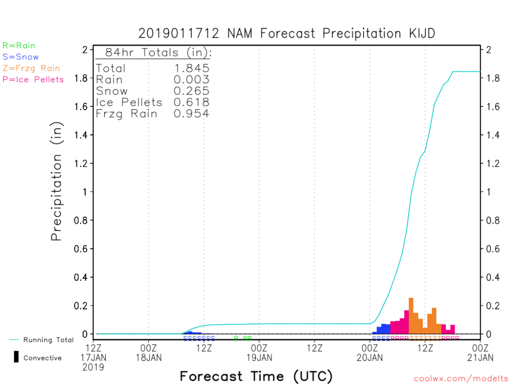
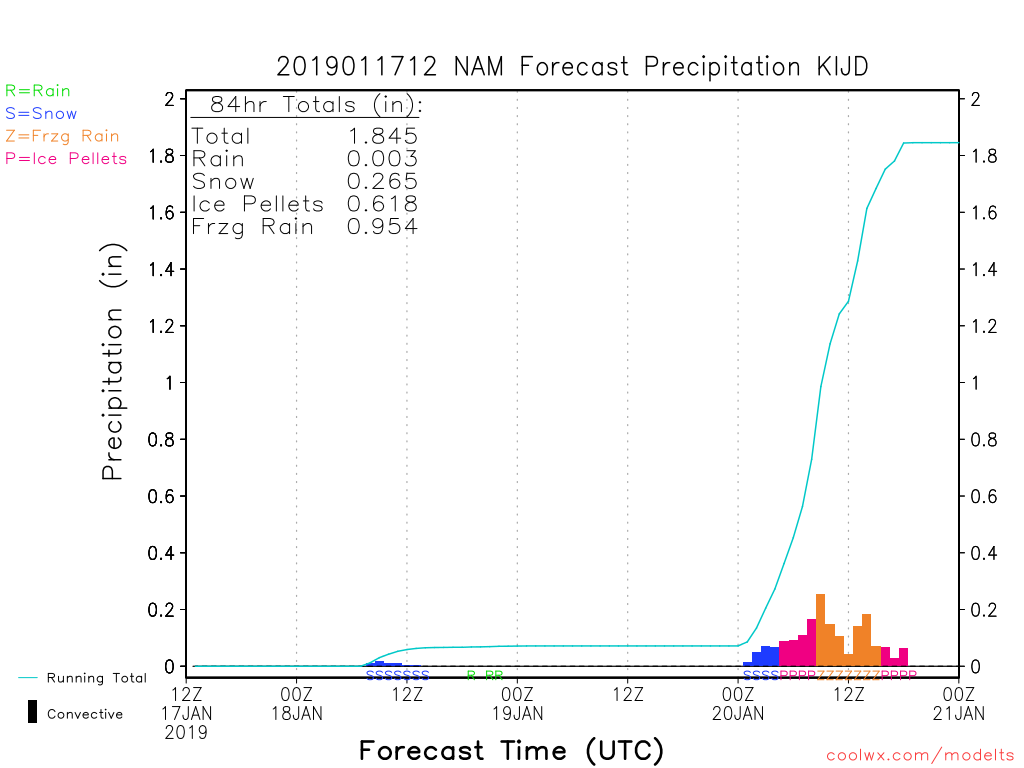
Wow, the 3km NAM is cold. 850s only creep above 0c about 15mi N of the south coast.
yeah...it was much more in line with the 12km at 6z...they were quite a bit different last night at 0z, with the 3km being rather toasty. I will say NAM has certainly backed off the prolific fzra totals it was spitting out for CT yesterday. Seems to be a combo of less QPF and an overall colder trend. 6z even kept GON mostly below freezing. Hoping that holds here at 12z.
-
1
-
-
Not liking this look...could get ugly for someone in southern CT
-
1 hour ago, SnowGoose69 said:
Other than the NAM the Euro is the only model showing that weak overrunning that far north from 84-96. Given that is outside the Euro’s ideal range it may not be reliable
even then 18z NAM moving in the wrong direction
-
5” here...have transitioned to mostly sleet. Looks like rain is on the doorstop. Still, not too shabby for mid November and a great way to kick off the season!
. -
9 minutes ago, CT Rain said:
You got robbed in 2012... places just west of you had a foot!
I remember being happy with the 3". Like I said, I don't think I was expecting any accumulation so when we got in on the action a bit beginning around dusk I'm sure I went into full weenie mode. I should also add that 2010/11 & 2012/13 rocked down this way, so if we can whiten the ground a bit Thursday night then clearly we're headed towards a blockbuster winter.
-
35 minutes ago, CT Rain said:
I will say the boundary layer doesn't look like an issue with a really good cold source and nice northerly ageostrophic flow. Could surprise to the coast.
in the past 10 years at my current location I've only accorded accumulating snows in November twice...~0.5" on 11/8/10...and 3" on 11/7/12 (which according to my notes was unexpected). wouldn't mind adding another November snowfall to the record books.
-
15 minutes ago, Go Kart Mozart said:
Any reports from posters under the very narrow band from about East Hartford to Madison? That thing has been stuck for a while.
been under it here in Clinton for a couple hours...have picked up a couple inches. Looks like it may be getting ready to fizzle out shortly though
-
6 minutes ago, sankaty said:
Still cranking under that skinny band over central CT. Very heavy snow at times.
fortunate to get stuck under the same band down here. Only thing that prevented a complete disaster here...might still manage 5", would've been 3" at best without it.
-
4 minutes ago, Ginx snewx said:
4.5 new Moosup Ct heavy snow some branches breaking
dang...only about an inch back this way. intensity has picked up a bit in the past 1/2 hour, just getting into the edge of that deform band. my nowcast senses telling me we don't sniff the higher range of forecasts back this way...should still be good for 5-6" so long as we are solidly under some deform snows for a bit.
-
First flakes falling now near the shoreline. And with that I’m off to bed.

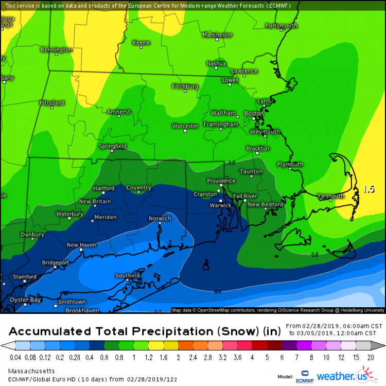
Perhaps a Coastal Storm on March 2nd for SNE????
in New England
Posted
3.5” here...biggest snow since November and 3rd day in a row with measurable snowfall. Is this what deep deep winter is?
.