

Scraff
-
Posts
4,412 -
Joined
-
Last visited
Content Type
Profiles
Blogs
Forums
American Weather
Media Demo
Store
Gallery
Posts posted by Scraff
-
-
3 minutes ago, stormtracker said:
I mean, I'd take the ICON without hesitation and call it a day
Same! Maybe as we get closer we juice it a bit more and get some 4-5” lollis.
")
-
Pass on the NAM. When do the real pro models run? You know like Deep Thunder, CRAS, the Farmers Almanac.
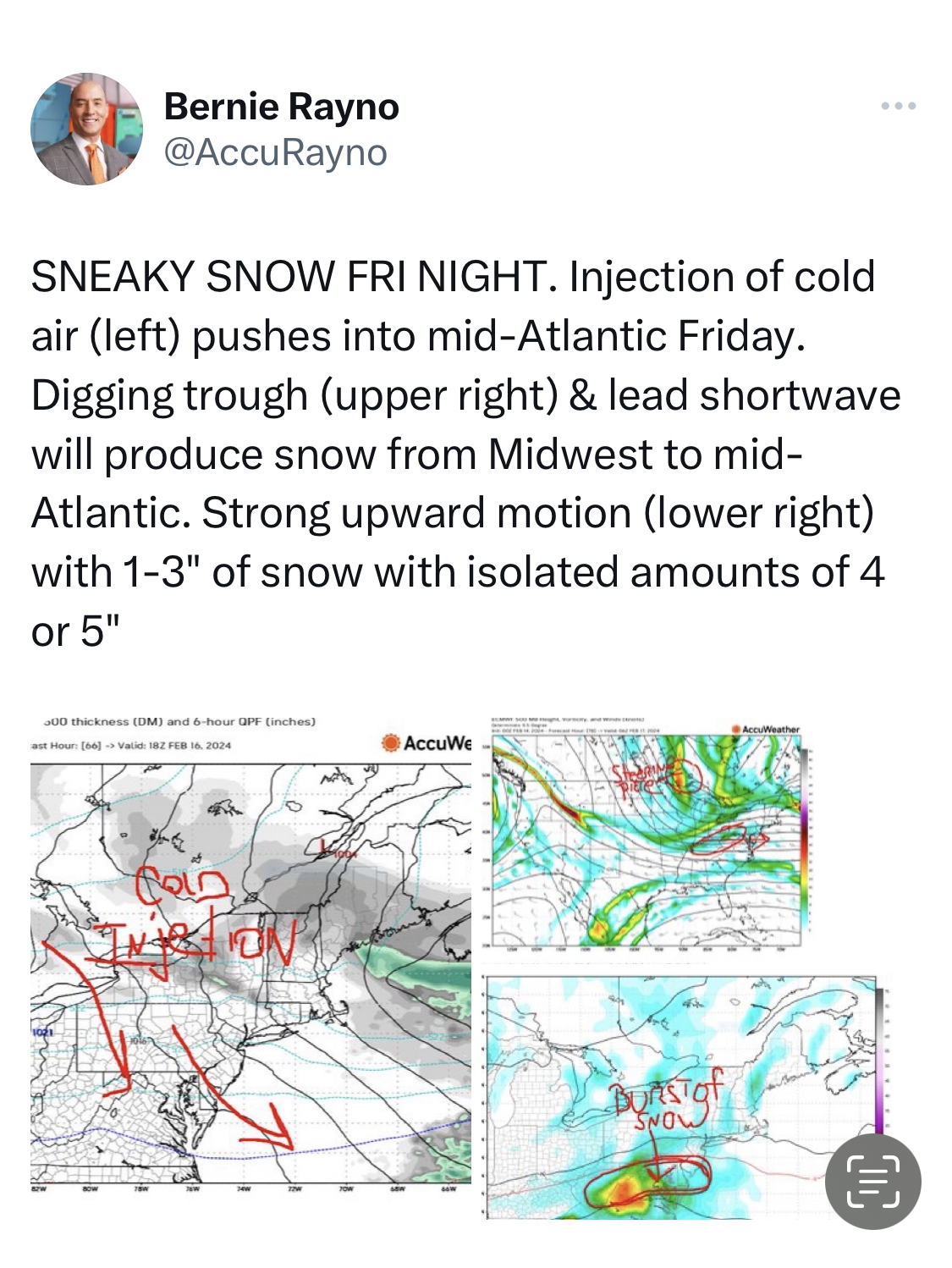
ETA—here we go with Rayno…

-
 2
2
-
 1
1
-
-
I’ll start by saying I’ll take a nice overnight few inches. Super happy with that option. Friday into Saturday would be perfect for beers, Jebwalks, and acting silly all night in the OBS thread. However, for shits and giggles, how do we wrangle that gulf moisture into play? It’s intriguing. And we’re 3 for 3 in getting things to go our way. So thoughts?
-
1
-
-
2 minutes ago, Eskimo Joe said:
That's like a classic 90s snowstorm.
In tribute, I’ll go listen to the new Pearl Jam song for the 5th time. Lol. But yeah, definitely got a classic feel.
-
19 minutes ago, yoda said:
Very similar to 12z ICON

We abscond.

-
2
-
-
Damn. Pummeling down right now. Wish this had started when my alarm went off at 6am.
-
1
-
-
9 minutes ago, Kay said:
So cool that they're still touring
Lost the rates and it's light snow/white rain here. No accums.
They’re getting kinda of old, but can still shred with the best of them. Don’t know if they can keep this up every winter, but I’ll buy a ticket every time they come to town.

ETA: Just hit the stage. Unfortunately they said it’s their last song today as they see JI screaming about a back edge or something. Meh. Whatever.
-
1
-
-
MoCo / HoCo deathband setting up on stage now?
")
-
2 minutes ago, osfan24 said:
It tries but it never really does. Those HRRR advertised rates were hilarious.
It’s pretty damn heavy at my house currently.
-
Small to medium flakes. Looks like it’s about to rip.
-
2 minutes ago, WxUSAF said:
Starting to mist again in Columbia. Don’t hate the radar…just needs to get here.
Looks like we’re on the cusp …
-
10 minutes ago, nw baltimore wx said:
Carroll and Frederick MD closed.
HoCo will be an interesting call.
-
1
-
-
Damn it! A ball of fire in the sky is coming up in the east. That pivot better happen fast or we are totally screwed.
-
1
-
-
1 minute ago, nw baltimore wx said:
The dryslot is a bummer but there’s precip redeveloping to the southwest and with the pivot, I think there still could be a few hours of good snows this morning.
Radar definitely filling in. Maybe by 7:00 I’ll see a few white asteroids. Gives me time to get my coffee game on.
-
1
-
-
3 minutes ago, DarkSharkWX said:
central md was expected to switch over at 6-8 am and we probably will
.Switch over from what? Dryer to driest?
-
1 minute ago, WxUSAF said:
Been awhile since I’ve seen a pivot on radar like this #ifonlyitwascolder
#Ifonlyitwasprecipitating
-
1
-
-
Perfect timing. Sets the alarm for the dry slot.

-
6
-
-
2 minutes ago, Kevin Reilly said:
That's classic take a look at the radar down there in NE Kentucky Wow! A clear center and another racing up from the south almost looks like they want to co locate.
As long as they co-locate over the DMV and rip white asteroids…

-
2
-
-
1 minute ago, wxmeddler said:
Baroclinic Leaf Time..
Oh sweet! I had Baroclinic Leaf on my Bingo card.
-
1 minute ago, StormyClearweather said:
Ahem


-
 2
2
-
-
4 minutes ago, Round Hill WX said:
Poor Yoder….he gets no snow and still has to give Randy $200.
Maybe they can meet up to swap funds in Georgetown. Roads should be just fine there.
-
2
-
-
I don’t know how, and I’ll believe it when I see it, but we might have just reeled in something out of nothing again. Snowtown USA baby!

-
1
-
-
URGENT - WINTER WEATHER MESSAGE
National Weather Service Baltimore MD/Washington DC
312 PM EST Mon Feb 12 2024Southern Baltimore-Central and Southeast Howard-Eastern Loudoun- 312 PM EST Mon Feb 12 2024
...WINTER WEATHER ADVISORY IN EFFECT FROM 3 AM TO 1 PM EST TUESDAY...
* WHAT...Rain changing to snow is expected. Total snow accumulations of up to two inches. Winds gusting as high as 35 mph.
* WHERE...In Maryland, Southern Baltimore and Central and Southeast Howard Counties. In Virginia, Eastern Loudoun County.
* WHEN...From 3 AM to 1 PM EST Tuesday.
* IMPACTS...Plan on slippery road conditions. The hazardous conditions could impact the morning commute.
* ADDITIONAL DETAILS...Rain is expected to change to snow between 5 AM and 7 AM. Snow will be heavy at times, with rates of around 1/2 to 1 inch per hour through mid-morning Tuesday. Visibility may be reduced to less than one half mile at times.
PRECAUTIONARY/PREPAREDNESS ACTIONS...
-
1
-
-
Queen RAP for the win! Yaaaaas Queen!!
ETA: Just got a WWA for HoCo. Here we go!
-
1
-

The Weekend Rule? Saturday 2/17 - The Icon Storm
in Mid Atlantic
Posted
Biggest Euro run of the winter! LFG!!