

wxsniss
-
Posts
5,523 -
Joined
-
Last visited
Content Type
Profiles
Blogs
Forums
American Weather
Media Demo
Store
Gallery
Posts posted by wxsniss
-
-
Thunder in Fenway area
-
This is really impressive
LLJ taking its time lifting north
Heaviest of day right now, hoping we hear some thunder
Love the activity in here… if only this was January
-
Theories?
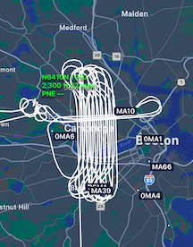
Easily audible so I checked FlightAware. Looks like a systematic screen.
This one ~9pm Monday March 3 took off from Hanscom:
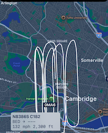
A 2nd one ~11:30pm took off from Northeast Philly:
-
Some younger folks here might be interested in this… summer student volunteer program with NWS Boston:
-
Fond memory on multiple levels... the turning point, Euro ~60 hrs prior... went from OTS to a retro for a few inches to a blizzard:
-
 1
1
-
-
1 minute ago, mahk_webstah said:
Good time to put the closing thoughts on this thread.
the Iggles flew high.
A good number of weenies got to high five though not as many as I hoped.
Thanks for letting me start a thread.
Let’s see if indeed this storm is the first of a decent run over the next few weeks
Congrats!
I think most here were thrilled not to see a 3peat!
-
~5-5.25" in Brookline
I love the fresh stark white on everything
-
43 minutes ago, CoastalWx said:
Haven’t gone outside but about 4” or so give or take. 6” streak goes on for 3 years. Light snow currently.
Take a 3peat tonight to the bank?
-
Look at Feb 9 0z HREF… 3z/4z RAP and 3z/4z HRRR, that’s go-time guidance… even short term mesos failed horribly here in handling dry air, had it snowing in east at least through 7am
-
Brookline: Great snowgrowth and heaviest rates of season, has to be at least 1”/hr
RAP HRRR HREF look good esp NOP and NEMA
-
1
-
-
Warnings up
This degree of model consensus seems so rare lately
-
1
-
-
Been a while since we've had a no-drama significant storm...
Regionwide 6-10" would probably accurately cover almost everyone outside Cape/southcoast
-
1
-
-
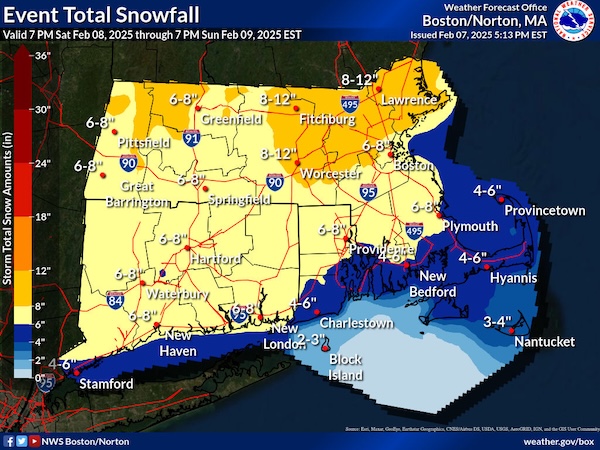
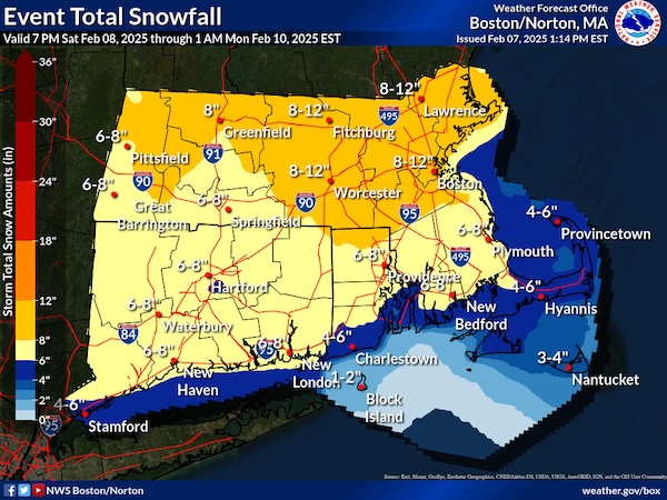
Just saw this from Box, sorry if posted earlier...
Are they relying on ratios for such widespread 8-12"?
Solid event incoming for a change... most guidance supports widespread 4-8", maybe some spots 8"+
-
1
-
-
Actually decent 4-day-lead consensus EC / GFS / CMC for once
-
Healthier SWFE and that fledgling CCB keeps improving
Widespread warning snows, would be SNE's largest storm of season so far
-
2
-
-
-
Earthquake?
definite shaking in Fenway area
-
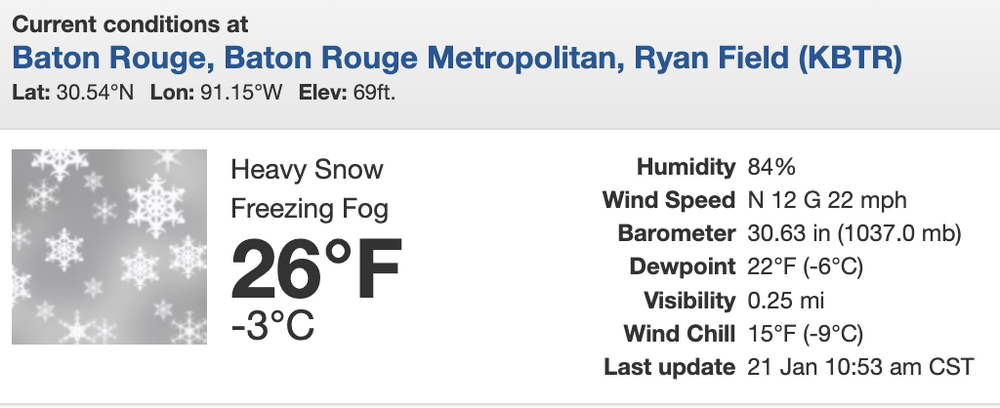
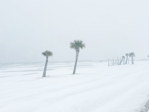
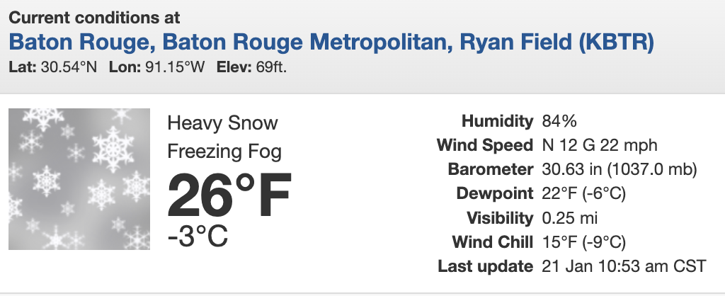
Wow...
KBTR 211653Z AUTO 02010G19KT 1/4SM +SN FZFG VV004 M03/M06 A3063 RMK AO2 SLP370 P0010 T10331056 RVRNO
-
3
-
-
Beautiful night (photos below before deform band came through...)
Looks like a beautiful white against bluebird sky now.... rushing to get kids out to sled, rare opportunity with no school or official work day!
Congrats to South Shore folks who badly needed this. Looks like Boston reports made it to 5-5.5".
We nickel our way back to yore, still a long way but we'll take it!


-
2
-
-
Happy for the South Shore folks, spreading the season wins
Be careful out there, it's slippery AF, flash frozen layer underneath
I'll make another measurement around 12-1am
-
2.1" at 10:15pm
Beautiful winter scene outside, heavy snow... baby steps back to yore

-
2
-
-
Increasingly confident of 5"+ for Boston metro
33F, roads covered completely, should see 1"+/hr rates next 3 hours
-
1
-
-
34F (down 5F in 30 min)
We're beating the 8pm mark for good snowgrowth and accumulation
Looking upstream, if 850 fronto is any prognostic, Boston metro into northeast MA will crank 9-11pm

-
 1
1
-
-
35F, moderate snow (Coolidge Corner Brookline)
Roads starting to whiten
Temp dropped 4F in ~20 min


May 2025 Obs/Discussion
in New England
Posted
Amazing feed, just keeps going into Boston metro... another rumble heard at 12:30am looks near Hingham