SACRUS
-
Posts
15,458 -
Joined
-
Last visited
Content Type
Profiles
Blogs
Forums
American Weather
Media Demo
Store
Gallery
Everything posted by SACRUS
-
Extreme Cold, Snow & Sleet: SECS 1/24 - 1/26
SACRUS replied to TriPol's topic in New York City Metro
12Z QPF Totals (NYC) ICON: 0.9 - 1.1 GFS: Trace GGEM: 0.6 - 0.8 GEFS: 0.5 - 0.6 UKMET: 1.00 - >1.00 Euro AI AIFS: 0.5 - 0.6 Euro: 0.7 - 0.8 GEPS: 0.9 EPS: 0.6 - 0.7 -
Extreme Cold, Snow & Sleet: SECS 1/24 - 1/26
SACRUS replied to TriPol's topic in New York City Metro
It'll be interesting to see the GEFS mean (12z) Op vs Ensembles -
Extreme Cold, Snow & Sleet: SECS 1/24 - 1/26
SACRUS replied to TriPol's topic in New York City Metro
That was when the MRF first moved to the GFS (first winter season) and the AVN to NAM -
Extreme Cold, Snow & Sleet: SECS 1/24 - 1/26
SACRUS replied to TriPol's topic in New York City Metro
The slower the progression once to Sun night / Monday the retreating high will allow the secondary low to gain latitude as the Euro shows and phasing capture. Timing is key and Euro /UK were leading there (so far) -
Records: Highs: EWR: 62 (2006) NYC: 62 (1951) LGA: 61 (2006) JFK: 56 (2013) Lows: EWR: -3 (1985) NYC: 0 (1994) LGA: 0 (1994) JFK: 3 (1994) Historical: 1606: 2,000 people died around the Severn Estuary as the result of severe flooding along the Severn River in England. (Ref. Wilson Wx. History) 1852: The temperature fell to 20 °F in Jacksonville, Florida and 22 °F in St. Augustine, Florida. (Ref. Early American Winters Vol. II 1821-1870 by David M. Ludlum pp. 109 - 110) 1863: The famous "Mud March" begins in the Fredericksburg area of Virginia. 1883: Yuma, Arizona, sets its all-time record low of 22 degrees. The record is tied in 1911 and again in 1937. 1917: 16 inches of snow falls in the Twin Cities, MN. (Ref. AccWeather Weather History) 1933: The greatest snowfall officially fell at Phoenix, AZ reaching one inch. Four years to the day later, another snowfall of one inch fell. (Ref. Wilson Wx. History) 1937 - The wettest Inaugural Day of record with 1.77 inches of rain in 24 hours. Temperatures were only in the 30s as Franklin D. Roosevelt was sworm in for his second term. (David Ludlum) 1933: Phoenix, Arizona, receives light snow between 7:55 pm and 9:25 pm 1937 - The wettest Inaugural Day of record with 1.77 inches of rain in 24 hours. Temperatures were only in the 30s as Franklin D. Roosevelt was sworm in for his second term. (David Ludlum) 1943 - Strange vertical antics took place in the Black Hills of South Dakota. While the temperature at Deadwood was a frigid 16 degrees below zero, the town of Lead, just a mile and a half away, but 600 feet higher in elevation, reported a balmy 52 degree reading. (David Ludlum) 1943: Strange vertical temperature antics took place in the Black Hills of South Dakota. While the temperature at Deadwood was a frigid 16 degrees below zero, the town of Lead, just a mile and a half away, but 600 feet higher in elevation, reported a balmy 52 degree reading. (David Ludlum) 1951: The maximum temperature for the date in Washington, DC is 70°F. (Ref. Washington Weather Records - KDCA) 1954 - The temperature at Rogers Pass, MT, plunged to 70 degrees below zero to establish a new record for the continental U.S. (David Ludlum) 1961: The "Kennedy Inaugural snowstorm" belted the mid-Atlantic and New England states. Up to 29 inches of snow fell in northern New Jersey and southeastern New York. Areas north and west of Boston, MA received over two feet. This was the 2nd of three major snowstorms during the 1960-61 winter season across the northeastern U.S. (Ref. Wilson Wx. History) 1978 - A paralyzing "Nor'easter" produced a record 21 inches of snow at Boston, 15 to 20 inches in Rhode Island, and one to two feet of snow in Pennsylvania. Winds along the coast of Connecticut gusted to 70 mph. (David Ludlum) 1982: Just over 17 inches of snow fell in the Twin Cities, MN. Amazingly, this record was to be outdone within two days. (Ref. AccWeather Weather History) 1984: An Arctic cold wave in the east through the 22nd claimed 42 lives across 14 states. One of the coldest readings was -40° at Minong, WI. Subzero readings were measured from the Rockies to New England. (Ref. AccWeather Weather History) 1985: The minimum temperature for the date is -2 °F. in Washington, DC. (Ref. Washington Weather Records - KDCA) A major Arctic outbreak brought extreme cold to much of the central and eastern U.S. Many all time record lows were set, including: Chicago, IL -27° (daytime high of -4 with a wind chill as low as -77°), Nashville, TN -16° (broken the next day), Asheville, NC -13° (broken the next day) and Raleigh/Durham, NC -3° (broken the next day). Even New Orleans was in the deep freeze with a low of 15°. Fort Wayne, INrecorded their coldest overall day, with a high of -11° and a low of -22°. South Bend, IN set their coldest January high temperature, at -6°. Quincy, IL set their January record low with -21°. St. Louis & Columbia, MO recorded their all-time coldest wind chill readings of -48°& -44°. Residents in Birmingham, AL woke up to an inch of snow on the ground and temperatures in the deep freeze. Readings remained in the single digits all day. The high temperature at Muscle Shoals in the northern part of Alabama never got above 0° that day. The extreme cold actually caused television cable wires to shrink, resulting in service disruptions across the state of Virginia.=(Ref. Wilson Wx. History) (Ref. AccWeather Weather History) 1987 - Gale force winds lingered along the northern Atlantic coast in the wake of a holiday weekend storm. High winds along the eastern slopes of the Northern Rockies gusted to 67 mph at Livingston MT, and high winds in southern California gusted to 70 mph near San Bernardino. (National Weather Summary) (Storm Data) 1988 - A storm in the Upper Midwest produced heavy snow and gale force winds. Up to 27.5 inches of snow was reported along the Lake Superior shoreline of Michigan, with 22 inches at Marquette. (National Weather Summary) (Storm Data) 1989 - The temperature in the Washington D.C. area warmed into the lower 50s for the Presidential Inauguration during the late morning hours, before gusty northwest winds ushered in colder air that afternoon. (National Weather Summary) 1990 - While heavy thunderstorm rains drenched the Central Gulf Coast States, with 4.23 inches reported at Centreville AL in 24 hours, unseasonably warm weather continued across Florida. Five cities in Florida reported record high temperatures for the date. Tampa FL equalled their record high for January of 85 degrees. (National Weather Summary) 1993: A fast moving 980-millibar storm (28.94 inches of mercury) produced high winds across the Pacific Northwest. A wind gust to 64 mph occurred at the Sea-tac airport in Seattle, WA; their 2nd highest wind gust ever recorded at that location. Winds gusted to near 100 mph at the mouth of the Columbia River. Over 750,000 people in the vicinity of Puget Sound lost power. Damage was severe, with 79 homes destroyed and 581 suffering major damage. In Oregon, wind gusts hit 89 mph at Netarts and 86 mph at Cape Blanco. The storm caused $130 million dollars in damage.(Ref. Wilson Wx. History) Heavy rains across Louisiana caused flooding. Nearly eleven inches fell in Lafayette, LA along with nine inches in Baton Rouge. (Ref. AccWeather Weather History) 1994: Relentless lake effect snow squalls dumped nearly 60 inches of snow at Adams, NY in only 17 hours The three day snowfall total in the town exceeded 100 inches, one of the greatest lake effect snowfall totals ever recorded. Frigid conditions persisted over the northeastern U.S. Rangeley, ME was the cold spot in the nation with a temperature of -45°. First Connecticut Lake, NH dropped to -44°. South Bend, IN completed its longest stretch of sub-zero weather at 64 hours. Both Pittsburgh, PA and Cleveland, OH also completed their longest stretch of subzero readings on record, with 52 and 56 consecutive hours, respectively. (Ref. Wilson Wx. History) Very cold conditions over the Northeast: Cleveland, OH and Pittsburgh, PA ended their longest continuous subzero periods with fifty-two and fifty-six hours respectively. Temperature bottomed out at -45 °F at Rangeley, ME. (Ref. AccWeather Weather History) 2006: A winter storm moved across northern Illinois during the afternoon and evening hours, continuing into early the next morning. A band of very heavy snow fell across northeast Illinois across Kane County, southeast McHenry County, northwest Cook County, and most of Lake County. Snowfall amounts in this band ranged from 10 to 12 inches. Outside of this heavy band, snow amounts ranged from 6 to 9 inches, but snowfall amounts tapered off quickly across south central DuPage and south central Cook Counties, with those areas receiving 3 to 5 inches. Some of the largest snowfall amounts included 12 inches at Elgin, 11.7 inches at Grayslake, 11.5 inches at Shabbona, 11 inches at Barrington, and 9 inches at Paw Paw. Northwest parts of the state saw ice accumulations around a quarter inch, enhanced by thunderstorms. (Ref. Wilson Wx. History)
-
15 / 1 off a low of 10 here. Overall cold to much below normal the next 11 days or through the 31st / 1st. Coldest days look to be 1/24-1/25 - perhaps temps at or sub 20 all day then single digit low (coldest since 2019 perhaps) , then again 1/28 - 1/30. The much talked WAA / overrunning and potential secondary developent later Sat (1/24) - Sun (1/25) and into Mon (1/26) and perhaps Tue (1/27 long duration event. Hints at additional energy clipper or southern in the 1/31 period. Beyond there moderation back towards / above normal.
-
Extreme Cold, Snow & Sleet: SECS 1/24 - 1/26
SACRUS replied to TriPol's topic in New York City Metro
GFS Total QPF: Euro AI AIFS: -
Extreme Cold, Snow & Sleet: SECS 1/24 - 1/26
SACRUS replied to TriPol's topic in New York City Metro
06Z Total QPF (NYC) GFS: 0.4 - 0.5 Euro AI AIFS: 0.9 - 1.1 Euro: through 144 looked more or less in line with the 1/20 00Z GEFS: 0.6 -
Extreme Cold, Snow & Sleet: SECS 1/24 - 1/26
SACRUS replied to TriPol's topic in New York City Metro
Euro total QPF long duration into Tue -
Extreme Cold, Snow & Sleet: SECS 1/24 - 1/26
SACRUS replied to TriPol's topic in New York City Metro
00Z QPF Summary NYC GFS: 0.4 GGEM: 0.9- 1.1 UKMET: 0.8 - 1.0 GEFS: 0.4 - 0.6 GEPS (Canadian Ensemble mean QPF): 0.8 - 1.0 Euro AI AIFS: 0.4 - 0.6 ECMWF: Coming.. 1.0 -
Extreme Cold, Snow & Sleet: SECS 1/24 - 1/26
SACRUS replied to TriPol's topic in New York City Metro
GEFS - mean Total QPF GGEM GEPS -
Extreme Cold, Snow & Sleet: SECS 1/24 - 1/26
SACRUS replied to TriPol's topic in New York City Metro
GGEM Total QPF -
Extreme Cold, Snow & Sleet: SECS 1/24 - 1/26
SACRUS replied to TriPol's topic in New York City Metro
UKMET Total QPF -
Extreme Cold, Snow & Sleet: SECS 1/24 - 1/26
SACRUS replied to TriPol's topic in New York City Metro
GFS Total QPF -
Extreme Cold, Snow & Sleet: SECS 1/24 - 1/26
SACRUS replied to TriPol's topic in New York City Metro
Euro AI AIFS QPF -
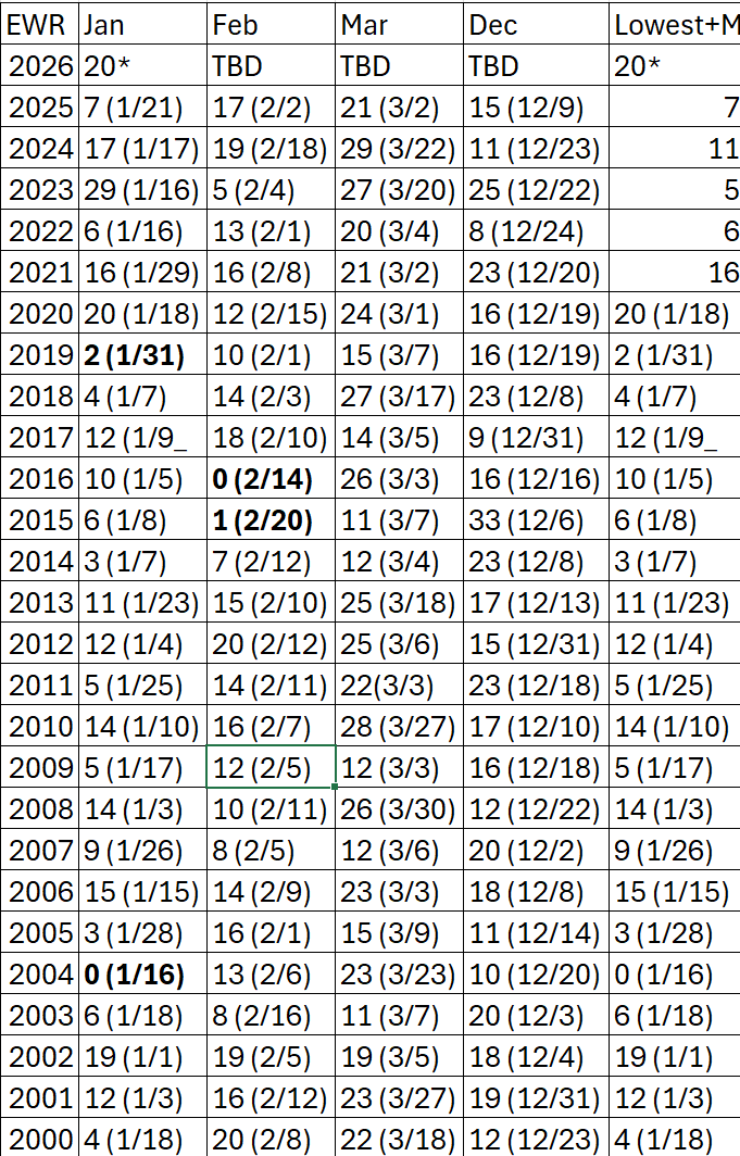
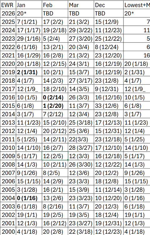
Recent coldest at EWR last 25 years: Bolded 5 and below
-
Down to 23 here and dropping Coldest air descending onto the upper MId West / G-L
-
Extreme Cold, Snow & Sleet: SECS 1/24 - 1/26
SACRUS replied to TriPol's topic in New York City Metro
The 18Z Euro was a bit south of 12z but still had snow into the region (north of the GFS). It only is out to 144 at 18z with likely a bit more at H150/H156. -
Ill have to check and i dont think we'll quite be in the single digitis in the city / metro areas byt of recent Jan 3 2014 comes to mind. Will need to check (low teens then)
-
Some flurries / snow squallls into PA with the front, maybe a stray flurry or shower makes it this way. Was up to 33 now clouds / mostly cloudy and down to 30
-
Your safest bet is to leave Friday or send flowers and stay back and enjoy the snow.
-
FRom the Mid Atlantic contingent
-
(A) is Anthony for that run. 32 / 19 here
-
12Z Guidance (QPF) Jan 24 OOZ to Jan 25 1800 Don or others can you add specific QPF for NYC? I think it'll be helpful to track run to run. GFS: 0 ICON: GGEM (CMC) : 0.75-1.00 UKMET: >1.00 ECMWF: GEFS: GEP: EPS:
-
Suspect we'll have the typical wax on / wax off windshield wiper suprssed / crushed run to run or model to model through Wed AM before honing in.