

NEGa
-
Posts
2,537 -
Joined
-
Last visited
Content Type
Profiles
Blogs
Forums
American Weather
Media Demo
Store
Gallery
Posts posted by NEGa
-
-
2 minutes ago, Ser Pounce said:
That's when the respective areas have at least a 5% chance of receiving TS winds, so they're going to show early date and times to reflect faster possible motion of the system.
Ah, thanks. Trying to keep up on the latest while I am at work
-
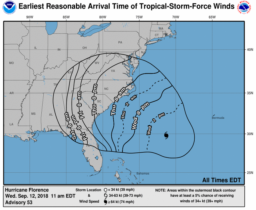
Am I misreading the latest update? I was under the assumption this storm (for NE GA, the Upstate and Western NC) was for like late Sunday or Monday. I guess I did not realize the storm would be starting earlier?
-
14 minutes ago, Lookout said:
I would be too quite honestly as storms moving northwest through ga are incredibly rare and to have two storms in back to back years like that would be incredible. There have only been a couple ever recorded. But even if it makes landfall in sc and tracks west, it would be amazing. In fact, i can only find one which made landfall in nc and the remnant low ended up in north ga way back in 1913 but it was a cat one and went well inland before getting here.. ( https://coast.noaa.gov/hurricanes/). So i'm really curious what it would be like if it makes landfall say near charleston and tracks west from there. Even with that track, the mountains would help compress the wind field and winds across the western carolinas and north ga could be quite high. Of course if it goes inland in nc before the stall and southwest/west turn we wouldn't have to worry too much about winds.
All i'm hoping for is some rain, it's actually gotten quite dry here. Do not want to go through all those hours of sustained winds, knocked down trees, and power outages. I got incredibly lucky i didn't lose power with irma and i sort of doubt i would be that lucky again if something similar happened.
thats for sure. we had some rain over the weekend ,but its been pretty dry here too lately (although through July it seemed to be raining every day). what is even more interesting in the track is the storm moving sw over the Gulf Stream. if I recall, many storms (hurricanes and noreasters) get a little nudge to the north as they approach the coast. to have it move sw over the gulf stream seems a bit odd
-
5 hours ago, Lookout said:
yeah not good...the euro takes the core of whats left of the strongest winds right across here. Irma was such a unique case that it's hard to believe that we could do it again just one year later. Unfortunately a lot of people lost power for days on end and that was just a tropical depression/weak tropical storm by the time it got to the al/ga border. hopefully it will only be a minimal hurricane at landfall and it wont' be as bad.
Well this new track was weird to wake up lol. I thought Irma was a one time deal - if this were to happen again a year later I would be flabbergasted. Since it’s 5 days out I hope the track shifts again. I love wild wx but Irma did a lot of damage around here and I had no power for 5 or 6 days. The aftermath clean up was not fun lol
-
Ok thanks. Maybe it just started here. Took the dogs out and it’s wet but it’s sleeting here now
-
22 minutes ago, Lookout said:
I'm heading to gainesville in a little bit but the latest nam is unbelievably close to all snow even here...at least it suggests a sloppy mix of rain/sleet/snow..or even all snow if it's heavy enough...much of the day. Never ceases to amaze me how often it comes down to not just one degree here every time. Probably a good sign for much of NE Ga/upstate if i'm this close way down here.
valid at 18z this afternoon
Is it snowing in Gainesville? Just woke up to rain here lol.
-
Ditto to big frosty. Love any Frozen precip. Heavy snow and coating of ice is fine by me. I enjoyed Monday/tues ice storm
-
After paying Tracker off....here it is! Good Luck and behave yourself!
um so i see lol. i was about to pop in here and ask who you bribed, but danggit you already admitted it. so how much did ya have to shell out

-
i just made a post in the banter thread, and realized i meant to put part of it here lol. i think there may be some confusion with some - the issue isnt really not asking questions and not learning. its not doing so in the main storm/model discussion thread. there is a logical reason for this -
remember, when the mets and pro forecasters are talking about the latest runs, they are doing so in real time as we all are. so they dont have the time to analyze and read all of the panels for all areas. they focus on their areas, of course, and the blanks get filled in as the discussion progresses. they are taking time to post their comments here free, and this is their profession, and that is the time for them to shine

maybe we could have two threads on the models - the main one and a novice one
 letting the novice one have a lot more questions and sort of a learn as you go thread. we all had to learn, and most in the se thread readily answer questions. but the IMBY questions as the models are running and being analyzed is just not really the most appropriate thing to go in that thread.
 i guess i just dont understand what the big deal is about keeping the main discussion thread clean and for a specific purpose (and keeping out unnecessary posts).
ask the same question in another thread, and not at the model run time, and chances are you will receive a much different response.
-
THIS is what got my goat during the last event!! As many times as we (Georgia guys/gals) have sat on the sidelines and rooted for our SE brethren while we got 33F and rain, there was plain nastiness by a few in here over us getting our once in every Blue Moon storm. Very disappointing. I realize that everyone is truly concerned about their backyard 1st and foremost and that's understandable. On the other hand, no one here controls the weather so if I can't get mine, I will be more than happy for you to get yours! (just be sure to post pics!
 )
)i agree - this year ga has been fortunate, but not the last few years. i think the 'regional bias' posts and in fighting in the se thread is what has really irked me this year. i have never felt this board to be 'nc' biased 'ga' biased etc. as we grow with more posters and have access to new info we can certainly try to be sure and include those areas. but just because n ga (or the upstate, or piedmont of nc) is in the bullseye, doesnt mean those out of it need to be nasty and say that the board is biased.
seems pretty obvious to me that whatever area the so called 'jackpot' is expected to be, is of course going to be the area of primary concern for a while.
-
Try not to pick a fight eh? NEGa I hate you.

How much for my area?
 It's a bust? NOOOOOOO.
i hate you too. i will see you in the parking lot after class. um, and that gosh awful blue bouncing thing needs to be banned. permanently
 most of the people that was really directed at i think have been properly dealt with by our mods since i havent seen many of them around.
 i just hope we have enough more winter wx to go this year to make this thread worth while (i mean if it warms up next week and stays that way, a lot of the posters will disappear lol)
-
good thread! also, pls try not to be rude and insulting (or pick a fight). we have been over the regional areas (whats in the SE, is n ga I20 etc), and most people know what part of the state they live in.
if people would just read before posting, many times their question has been answered. do not insult pro mets and do not pester them - they are doing us all a huge favor by posting here. and yes, what is posted here is probably not in the official NWS forecasts. the board is for discussion and possibilities.
the thing that i have noticed the most are the new posters seemingly trying to pick a fight or make a mountain out of a mole hill. please be respectful to others

-
<br />PHEW, for all IPAD users who had issues, click off RTE rich text editor under your settings, it will allow full normal access.<br />
Is this this fix to stop all the HTML tags or to increase speed the pages load? Using mobile skin it works great, the only issue i have had are the extra tags (which is fine as long as i can post and reply lol)
-
I am checking from an iPad...wasn't able to get on yesterday but it seems to be working fine now (Saturday morning)
Hurricane Florence
in Southeastern States
Posted
I noticed that too - a big difference on ne ga and upstate rainfall totals right now. its hard to know which one to believe lol