

Chase
-
Posts
486 -
Joined
Content Type
Profiles
Blogs
Forums
American Weather
Media Demo
Store
Gallery
Posts posted by Chase
-
-
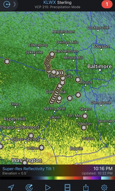
Snowing in Falls Church.
-
1 minute ago, showmethesnow said:
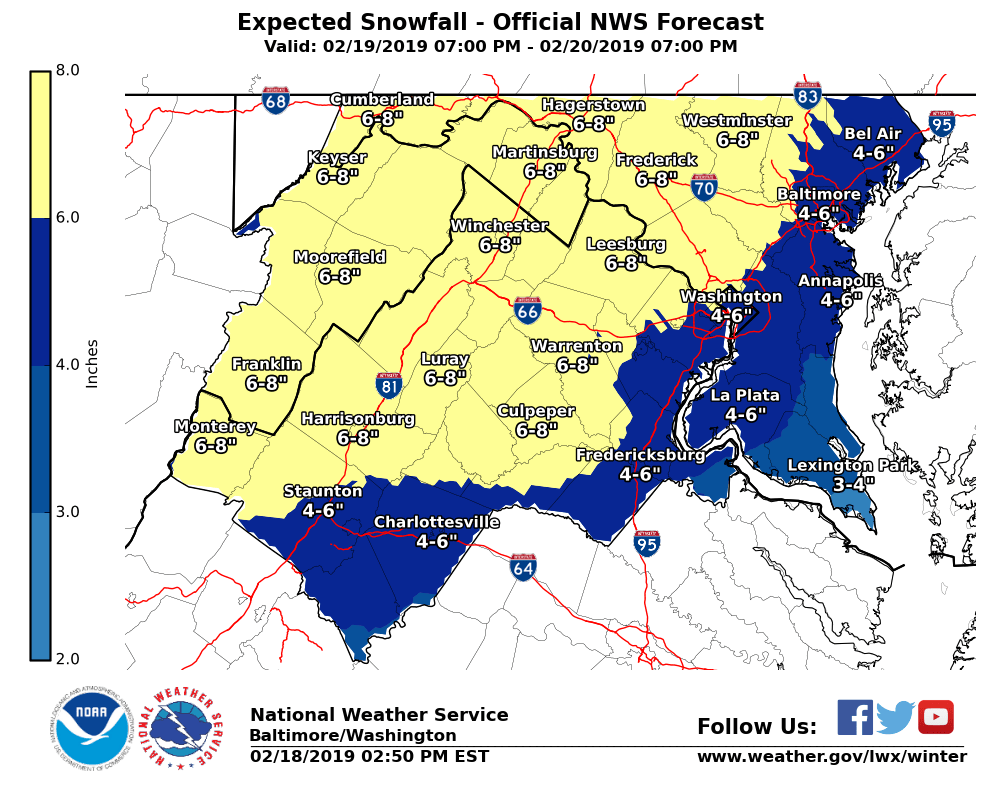
Kind of like what they have showing for the DC/Balt corridor and central MD as it pretty much mirrors my thoughts over the last couple of days. (2-4) up 95 from DC to Balt. (3-6) north and west burbs. (4-8) around the PA line.
And as far as the discrepancies between the 50% and the high and low ends? I have to question if that may be because the 50% is generated by both human input and computer vs. the other two being generated solely by computer. Just a thought and could very well be wrong.
This is no longer the forecast showing on their site.
-
3 minutes ago, Eskimo Joe said:
Heh, LWX chops totals again.
Nah. They updated again at 4:25. No idea what the 4:10 blip is.
-
43 minutes ago, Jrlg1181 said:
And still nada 55 miles south of you in the Waynesboro area...... dry dry air...
Once it starts in Augusta County, it should creep up to Luray within 90 minutes. Then the Beltway another hour after that.
Im seeing MPING reports showing snow west of Staunton and near Greenville. Anybody down there?
-
1 hour ago, SnowBeach said:
Made it to my chase location at a cabin just west of Luray at 1700 ft. Scotch, hot tub, and radar watching time.
Hooray for Luray!
-
 1
1
-
-
Just now, BaltimoreWxGuy said:
How about some weenie radar hallucinations? The thunderstorm near Atlanta looks prime for tracking in our area

The convection is going to rob our moisture.
-
1
-
-
-
Which one of you did this?
-
2
-
 2
2
-
-
5 minutes ago, haudidoody said:
Had maybe 0.5" before the switch... now changing over in Fairfax.
Oh no... where in Fairfax are you?
About a half inch in Fair Oaks but no switch yet.
10:09 edit: Nevermind. Switched

-
Snowing at a pretty decent clip and breezy in Fair Oaks. Haze shows up nicely in the lights.
-
1
-
-
Snowing in Fair Oaks.
-
1
-
-
34 minutes ago, grhqofb5 said:
is it me or is there an enormous snow hole/circle over Anne Arundel, Montgomery, Howard, PG, and DC rigt now. God is laughing at us.
I would assume it’s the radar beam and it doesn’t snow virga close by.
Just like the radar has issues out southwest of Luray.
-
Fairfax and Arlington now with the two hour delay.
PW is just ridiculous.
-
Snow falling at Sideling Hill between Cumberland and Hancock. Same with eastern Washington County. Not quite in the lower elevations yet.
-
14 minutes ago, mattie g said:
Fairfax County is brining roads today.

VDOT does all the roads in Fairfax, Loudoun, and PW.
-
We get a Special Weather Statement.
-
Gonna miss 66 to the north?
-
-
8 minutes ago, supernovasky said:
I've never seen a snow squall warning before. I'm excited.
It buzzes your phone like a FFW or Tornado warning. Get ready if it happens.
-
Grass caving in Fair Oaks. Moderate snow. 33/28
-
Sleet in Fair Oaks.
-
Had a trace of flakes on my car when I got out of the gym this morning in Merrifield.
-
3 hours ago, WxUSAF said:
I’d maybe agree but the rush hour aspect of it probably warrants a WWA for the entire CWA.
30 minutes ago, wxtrix said:i guess we don’t qualify for the rush hour option, lol.
Trixie's correct... the LWX WWA "1 inch at Rush Hour" criteria is only for the areas that are currently under it.
WINTER WEATHER ADVISORIES WILL BE ISSUED FOR FORECASTER
CONFIDENCE OF 60% OR HIGHER OF ONE INCH OF SNOW AND
SLEET FOR BALTIMORE AND WASHINGTON COMMUTING AREAS.
•MORNING RUSH…4AM TO 9AM OR EVENING RUSH…2PM TO
7 PM.
• WEEKDAYS THAT DO NOT FALL ON FEDERAL HOLIDAYS.
• INCLUDES ALL OR PORTIONS OF INTERSTATES
95...695…495…83…70…270…AND 66. (MAP ON NEXT SLIDE
FOR DETAILS)
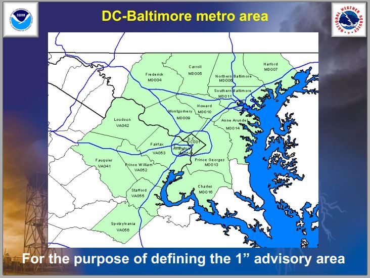
I guess no where else commutes to work. -
Yesterday was the Carmageddon 2011 anniversary. Any dynamic similarities? I remember that was rain that morning.
https://wjla.com/traffic/metro/2011-snowtowrm-hits-one-year-anniversary-71935
-
2
-

2/19-20 Winter Storm Observations
in Mid Atlantic
Posted
Can someone post it? I’m on my phone in the field.