

Chase
-
Posts
486 -
Joined
Content Type
Profiles
Blogs
Forums
American Weather
Media Demo
Store
Gallery
Posts posted by Chase
-
-
Cars topped in Fairfax.
-
 2
2
-
-
5 hours ago, Amorphous Iodine said:
Where is FEMA? Where’s the National Guard?
Governor Northam has to declare a "State of Emergency" first.
And that needs to be requested from VDOT or one of the localities. VDOT probably too proud to ask.
-
-
Still all rain here in Fair Oaks.
Dulles 39/32
Manassas 39/34
Fort Belvior 41/35
National 43/35
-
Snow mixing in in Front Royal per social.
-
All rain in Fair Oaks right now.
-
3 minutes ago, CntrTim85 said:
That's Tennessee you dipstick!
Loudon County is in Tennessee (and not a part of our forum). Suggest posting there.
-
4 minutes ago, CntrTim85 said:
My sister teaches in Loudon County. They are currently in a 2 hour delay. She has asked me to keep her apprised of the situation. She is anticipating a day off but would like as much notice as possible. This leaves me invested. Why can't you people just engage in conversation about the current weather and not attack people based on their locale? AGAIN, is anyone concerned about dry air eroding the precipitation field?
No one is concerned about it and Loudoun County Schools will be closed Monday. Keeping your sister apprised does not require you to post this much.
-
27 minutes ago, BTRWx's Thanks Giving said:
Would the current radar depiction be a good indication of the northern edge tomorrow?
Noted the same thing. I think it would be. Certainly where the snow maps have been honing that line from Shenandoah County through Loudoun.
-
17 minutes ago, CntrTim85 said:
How am I a troll? Because I ask the questions that upset people? I was just worried for you guys because I know how dry air erodes the back edge. Hence the reason for the sharp cutoff. Geeze.
Dawg, shh.
You’re right that Hampton Roads got more snow than the DMV last year. But as a fellow fan of Chesapeake, please do yourself and the city a favor and stop posting provocative stuff. If you don’t know what’s provocative enough yet, just read until you do.-
2
-
 1
1
-
-
27 minutes ago, nw baltimore wx said:
Loudon county schools are closed.

Loudoun is 2 hours late so far.
-
22 minutes ago, Ephesians2 said:
if this even comes close to verifying, DC radio will probably get a lot of public criticism ... just heard WTOP say "a few flurries north and west" Monday morning
Clay Anderson wanted to say it and showed models showing lots of snow, but he ended up saying “might get sprinkles.”
I expect Lauryn Ricketts tomorrow morning will do a much better job for NBC4.
-
 1
1
-
-
This used to mean something...
-
3
-
4
-
-
Just now, Deck Pic said:
Does anyone actually think we're getting an 8-12" 1-2"/hr event Thursday morning
Trend friend nope.
-
2 minutes ago, csnavywx said:
This 100%. Snowcover helped, but transpose this forward 6-9 hours and throw in some slightly lower ground temps and it would be way worse. It's very close as it is, but accretion efficiency wasn't quite there for a big dog ice storm.
I guess what do the next 12 hours look like? Light drizzle and more precipitation to the south should add more accretion, right?
I’m worried we’re calling it over before it’s over.
-
1
-
-
Anybody got a good regional radar link? I hate the NWS’s site.
-
Arguably small snowflakes or drizzle here in Fair Oaks. Barely anything in trees. Maybe half inch of sleet accumulation packed down though.
-
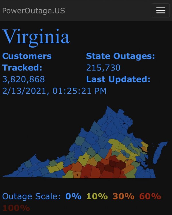
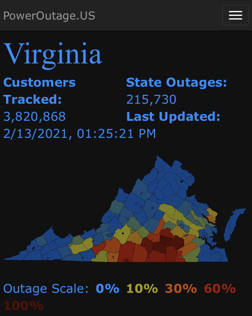
215K in Virginia without power as of 1:30pm, including nearly all of Nottoway and Dinwiddie Counties at this point.
-
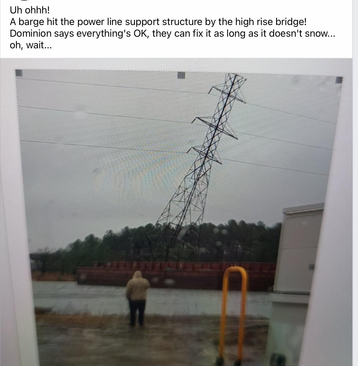
Bumpy rides in this evening.
-
1
-
-
2 minutes ago, WinterWxLuvr said:
Is it really necessary to post a county by county warning?
Posterity. Interesting how they did Warren, Shenandoah, Frederick in their individualized advisories.
-
2
-
-
The Winter Storm Watch is still showing in my point forecast. Is it still up too?
-
Just now, stormtracker said:
Well, I was wrong. Pleasantly surprised.
It’s early yet. Still 72 hours out?
-
A Winter Storm Watch will not be issued yet.
A Winter Storm Watch will likely be required by this
evening.
-
1
-
-
Watch issued for eastern West Virginia and western Maryland for 5-8" for part one.
Garrett-Extreme Western Allegany-Central and Eastern Allegany-
Western Highland-Eastern Highland-Hampshire-Hardy-Western Grant-
Eastern Grant-Western Mineral-Eastern Mineral-Western Pendleton-
Eastern Pendleton-
223 PM EST Tue Feb 9 2021...WINTER STORM WATCH IN EFFECT FROM WEDNESDAY EVENING THROUGH
THURSDAY MORNING...* WHAT...Heavy snow possible. Total snow accumulations of 5 to 8
inches possible.* WHERE...Portions of western Maryland, western Virginia and
eastern West Virginia.* WHEN...From Wednesday evening through Thursday morning.
* IMPACTS...Plan on slippery road conditions. The hazardous
conditions could impact the morning commute.* ADDITIONAL DETAILS... Additional snow is expected Thursday
afternoon through Friday.PRECAUTIONARY/PREPAREDNESS ACTIONS...
Monitor the latest forecasts for updates on this situation.


Jan 6/7 "Event" and obs
in Mid Atlantic
Posted
So Bill is gonna bust?