

Chase
-
Posts
486 -
Joined
Content Type
Profiles
Blogs
Forums
American Weather
Media Demo
Store
Gallery
Posts posted by Chase
-
-
Heavy freezing rain has a harder time accreting than light rain, just throwing that into the discussion.
-
37 minutes ago, Yeoman said:
I'm confused as to why you would give a s*** about what channel 5 says?
Be fair: Mike Thomas does a good job of explaining the models on social and helping the public gain knowledge.
And then there's Sue Palka . Put some respek on her name.
-
 2
2
-
-
Winter Weather Advisory extended for the metro area until 9am Tuesday.

-
Nice light snow in Fair Oaks, Fairfax.
-
Snowing in Luray as well.
-
2
-
-
10 minutes ago, clskinsfan said:
Anyone here down around Woodstock, VA? Is that snow or sleet?
Mixing in Luray.
-
 1
1
-
-
That band of gigantic snowflakes was beautiful! Now we are 100% sleet in Fair Oaks.
-
16 minutes ago, Flying Bouncy House said:
Things are starting to fall apart along I-81. A couple accidents already just by looking at the traffic cams.
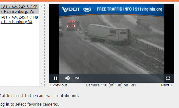
Actually mostly sleet in Harrisonburg so far.
-
Sleet in Harrisonburg according to video.
-
26 minutes ago, EastCoast NPZ said:
Not to jinx this, but I don't recall an instance where we truly got a major storm (12"+) out here and DC got next to zilch. As depicted, such a sharp cutoff seems not likely.
-
5 minutes ago, WxUSAF said:
Mt. Holly hoisted watches
Maybe LWX will hoist the Piedmont/Shen region into the Code Purple.
-
16 minutes ago, leesburg 04 said:
So if he were here he would tell you what?
On his Facebook, he said "Snow lovers haven't been this excited in 2 years
 . I'd follow what Capital Weather Gang has to say in coming days"
-
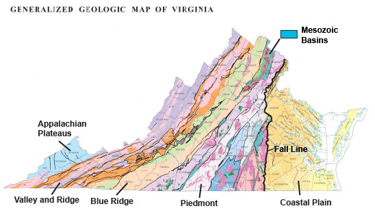
Regions of Virginia:
-
1
-
-
Those three hour totals.

-
 7
7
-
-
RNK has started to populate its snow map for Wednesday, giving us this up to the CWA line:

-
1
-
-
1 minute ago, Deck Pic said:
Recommendation to kill time after the 18z models. Get in your car and drive west.
Hooray for Luray!
-
1
-
-
Just now, Snowchaser said:
I'm shocked Cville is in the Red. Clearly they know more than me lol.
There are three regions on the map. Charlottesville is lumped in with Hagerstown, just like Fairfax is lumped in with St. Mary's.
Could be area for improvement in the future if it ultimately presents a problem, but I love the product!
-
4 minutes ago, Wonderdog said:
Why isn't there an enhanced area on that map?
Confidence isn't high enough/impact isn't high enough to be at Enhanced for the 95 corridor.
-
Stabilized modeling? or could this still tick north or be stronger?
-
Excessive Rainfall Discussion
NWS Weather Prediction Center College Park MD
416 PM EDT Sat Aug 01 2020

Day 1
Valid 2016Z Sat Aug 01 2020 - 12Z Sun Aug 02 2020

..THERE IS A SLIGHT RISK OF EXCESSIVE RAINFALL OVER THE OHIO
VALLEY AND ADJACENT PARTS OF THE EASTERN U.S...

...Ohio Valley into the Mid Atlantic...
We continue with a broad Slight Risk area that encompasses various
threat areas associated with an anomalously deep upper trough. A
well defined surface wave will lift through the Ohio Valley this
evening. Cells in the warm sector will be moving fairly quickly,
but the combination of moderate instability and precipitable water
values well over 1.50 inches will yield heavy short term rain
rates capable of producing flash flooding in sensitive basins. Out
along the warm front, storms initiating off the Blue Ridge or more
generally in the very moist and unstable air mass pooled along the
Virginia portion of the warm front will have potential to produce
very heavy downpours. Increasing inflow speeds could yield pockets
of training or propagation back into the inflow if organized
clusters can persist into the evening hours. Overnight the
emphasis will shift to the deformation zone of the deep layer
cyclone approaching northwest Ohio and southeast Michigan. Strong
lift will work with instability rooted at mid levels to produce
some slow moving convection, with local inch per hour rates likely.

Finally, a threat exists over eastern North Carolina and southeast
Virginia for the next few hours, as the sea breeze and presence of
a lingering frontal zone will yield a local maximum of storm
initiation, allowing for cell mergers within a very moist and
unstable environment. The latest 12Z HREF exceedance probabilities
are quite impressive -- with probs of >1"/hr rates peaking over
80% across this area between 20-00Z, with probs of >2"/hr rates
equally as impressive during the same time (40-60%).
-
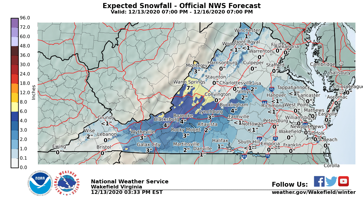
WWA for the Blue Ridge.
-
1 hour ago, WinterWxLuvr said:
What’s 17 degrees between friends? LOL
17... 22... what's it matter?
Of note, I thought all the local news was calling for the 60s so maybe it's a data problem on LWX's website. -
Showing 62 at IAD... Forecast high is 45 on the LWX Point Forecast.
-
When can I plant grass seed?
February 10-12, 2021 Winter Event
in Mid Atlantic
Posted
Like the roads on Wednesday night!