

Chase
-
Posts
486 -
Joined
Content Type
Profiles
Blogs
Forums
American Weather
Media Demo
Store
Gallery
Posts posted by Chase
-
-
Snow chasing at my parents' in the Shenandoah Valley. KLUA (Luray Caverns) bottomed out at 23 last hour, but is up to 25 now. Local PWS stations also rising.
It's over.

-
Now to watch Doug Kammerer latch onto it and whip up a frenzy.
-
15 minutes ago, Terpeast said:
Even southern MD is under code yellow? Bullish much?
They only have three zones (the heavier black outlines), not county-by-county. Don't read too much into that.
Western ridges, Shenandoah Valley/north and west suburbs, and I-95/Southern Maryland.
-
 1
1
-
-
Any local TV stations streaming?
-
Anybody know where this radar indicated rainfall basemap comes from? Did LWX do the smoothing themselves? The only spot I know is https://water.weather.gov/precip/ and the detail is pretty low.
Does anyone have an online resource they can recommend? -
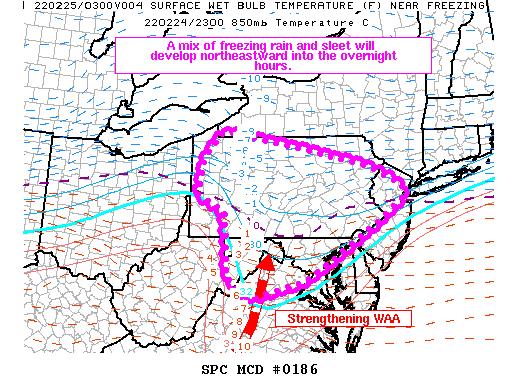
Mesoscale Discussion 0186
   NWS Storm Prediction Center Norman OK
   0813 PM CST Thu Feb 24 2022

   Areas affected...Parts of PA...far northeastern WV...far northern
   VA...MD...and northern/western NJ

   Concerning...Winter mixed precipitation

   Valid 250213Z - 250715Z

   SUMMARY...A mix of freezing rain and sleet will develop
   northeastward into the overnight hours.

   DISCUSSION...Latest water vapor imagery depicts a strong shortwave
   trough and accompanying midlevel speed maximum advancing eastward
   across parts of the Middle MS Valley. Ahead of the shortwave trough,
   surface observations show pressure falls being maximized in the OH
   vicinity, where a low pressure system will continue to develop over
   the next several hours. As the cyclone deepens, increasing southerly
   flow and related warm air advection will overspread the Central
   Appalachians and Mid-Atlantic states, resulting in a gradual
   increase in winter precipitation in the 03Z-08Z time frame.

   Across the southern and central portion of the discussion area, RAP
   forecast soundings show 850-mb temperatures increasing to 3-5 C atop
   a shallow subfreezing layer, which will favor complete melting of
   descending hydrometeors prior to refreezing near the surface. This
   will result in primarily freezing rain, with rates as high as 0.05
   in/hour owing to the strengthening forcing for ascent and deep-layer
   moistening. With northward extent, observations and forecast
   soundings show a deeper low-level subfreezing layer, with 850-mb
   temperatures near 1-3 C, indicative of partial melting of
   hydrometeors and the potential for sleet and freezing rain.

   Farther north across northern PA, moderate snow is likely to develop
   where deeper cold air is in place, with an eventual increase in
   snowfall rates expanding northward into NY during the early morning
   hours.

   ..Weinman.. 02/25/2022
-
Just now, Maestrobjwa said:
Dang man GFS tripling down again? Huh...
It was successful with the Friday/Saturday storm at this range, right?
-
Just now, stormtracker said:


I just searched too. $192 if you come back Monday morning.

-
Light snow has begun in Fair Oaks.
-
1
-
-
1 hour ago, Solution Man said:
Are there any stations in VA reporting snow?
Luray is.
-
5 minutes ago, stormtracker said:
Did ya hear? We lost Meatloaf
That Amtrak wifi must've delayed the news aleet.
-
1
-
-
25 minutes ago, stormtracker said:
In an hour, I'll be on Amtrak during the 12z runs, heading to NYC for a day appointment. If the Amtrak wifi is per usual, I will have the internet speed of AOL 4.0 with a 56k modem. But I'll try my best to do some pbp.
Your vaccine should help with your 5G service, though!
-
1
-
 4
4
-
-
17 minutes ago, Solution Man said:
Brine watch
Can’t brine. It’s starting as rain.
And yes, Rush Hour Criteria WWA.
-
1
-
-
5 minutes ago, weathercoins said:
Are local tv weather people even mets anymore?
They are. Some better than others.
I think Doug Kammerer hypes too much (and re-writes history). The rest of 4’s weather team is good.-
1
-
 1
1
-
-
2 minutes ago, Ji said:
Lol the weather girl at channel 4 said awesome snowstorm is coming friday night and Saturday
Topper showed the raw output of the Euro. Compared to GFS. Under the pretense of showing how different the models are so far.
-
4 minutes ago, stormtracker said:
Really needed some today at my parents’. That sleet-snow-concrete was disrespectful.
-
1
-
-
1 hour ago, pazzo83 said:
anyone in the central shenandoah valley (staunton/h-burg)? I'm headed back to my parents on tues, wondering how they are doing. I chatted with my mom around 6pm and it looked like they had about 6".
We only got 6-8” here in Luray. Pretty hard to measure with all the blowing then sleet.
Starting to get freezing drizzle really do some work. It’s 28°.-
3
-
-
19/3 here in Luray
Riding out the storm with my folks.
-
8 minutes ago, Ji said:
ive been to winchester multiple times...i dont remember going to through the blue ridge mountains to get there lol
4 minutes ago, pazzo83 said:lol - if you take Route 50 or I-66 you clearly go over mountains.
And Route 7 between Bluemont and the Shenandoah... You literally go from Snickers Gap at 1079 feet down to the Shenandoah River.
Mount Weather is along Blue Ridge Road.-
2
-
-
6 minutes ago, Ji said:
that dosent really sound beautiful...isnt winchester east of the BR?
Shenandoah National Park/Skyline Drive runs atop the Blue Ridge. It is the boundary between Clarke and Loudoun counties.

-
1
-
-
2 minutes ago, Deck Pic said:
This is a great run for those just west of the mix line...maybe panhandle of WV? Haven't looked close
I-81 special…. 14” for Front Royal
-
Do you think…
-
5 minutes ago, Bob Chill said:
The thing that's bothering me the most about this storm is we just went 2 for 2. I mean sure, there's a strong case that the universe owes us some storms after some of the recent debacles. But still... 3 for 3? Idk man. We are who we think we were and stuff
We’re due… if you will.
-
3 minutes ago, Maestrobjwa said:
Wooo boy...this has a psychiatric day for the books. We go from the discussion this morning to memories of disappointment tonight. All colors of the forum on full display, lol
‘Twas the night before our snowpack melts and all through the house…
-
1
-


January 6-7 Storm Discussion: we’re due?
in Mid Atlantic
Posted
It's gonna be great!
A couple inches will be great to see. Anything else will be icing on the cake or driveway.