

HoarfrostHubb
-
Posts
58,477 -
Joined
-
Last visited
Content Type
Profiles
Blogs
Forums
American Weather
Media Demo
Store
Gallery
Everything posted by HoarfrostHubb
-

December 2025 regional war/obs/disco thread
HoarfrostHubb replied to Torch Tiger's topic in New England
Meh. A possible solution. -
December 2025 regional war/obs/disco thread
HoarfrostHubb replied to Torch Tiger's topic in New England
Somewhere in Ayer, MA, fingers are getting ready to type -
KFIT reached 63. I got into the upper 50s
-
December 2025 regional war/obs/disco thread
HoarfrostHubb replied to Torch Tiger's topic in New England
Might start a bit later than that. I’m thinking noon/ish for a lot of folks (as currently modeled). But nobody knows… -
December 2025 regional war/obs/disco thread
HoarfrostHubb replied to Torch Tiger's topic in New England
Wunderground’s Franken-model likes it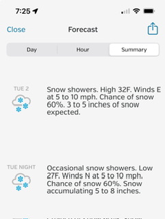
-
December 2025 regional war/obs/disco thread
HoarfrostHubb replied to Torch Tiger's topic in New England
Some pingers seem likely. -
December 2025 regional war/obs/disco thread
HoarfrostHubb replied to Torch Tiger's topic in New England
Wagons north -
December 2025 regional war/obs/disco thread
HoarfrostHubb replied to Torch Tiger's topic in New England
A good December would be appreciated -
December 2025 regional war/obs/disco thread
HoarfrostHubb replied to Torch Tiger's topic in New England
Yeah. I was watching a video of it earlier and that’s what prompted me to ask -
December 2025 regional war/obs/disco thread
HoarfrostHubb replied to Torch Tiger's topic in New England
32 years ago today. -
December 2025 regional war/obs/disco thread
HoarfrostHubb replied to Torch Tiger's topic in New England
Dumb AmWx vocabulary question: When people are referring to Leon (Lett) are they talking about the Super Bowl fumble in Jan 1993 or the game against the Dolphins in Nov of 1993 when he pushed the ball close to the goal line and the Dolphins recovered? -
December 2025 regional war/obs/disco thread
HoarfrostHubb replied to Torch Tiger's topic in New England
I like the cold look. Whether that produces anything precip-wise tbd -
December 2025 regional war/obs/disco thread
HoarfrostHubb replied to Torch Tiger's topic in New England
It’s got a heartbeat at least
-
To go back and forth to our daughter’s school we go on Rte 9 through there
-
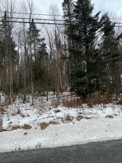
Some snow OTG in the woods of Woodford VT around 2000’ asl
-
Yep. 1st skim ice on the pond i drive by in my town each day. 20F for my low
-
They are actually making snow right now. And yeah…they will only be opening trails off of two lower lifts for now. I would still think they would start blasting on Conifer in a week or so if temps allow
-
Little ol' Wachusett in MA is opening Saturday Nov 22. 6 days earlier than usual (they shoot for Black Friday) If anyone wants to save $10 per season pass (a drop in the bucket) message me
-
Same here (22.5 for MPM). Coldest of the season.
-
Boredom for the next week
-
Squall coming through here. Nice.
-
Mattapoisett is pretty sweet
-
Six of the last 7 days here with at least some flakes in the air
-
Wishing you and your family the best Brett.
-
I was hoping to do a final cleanup this weekend.


